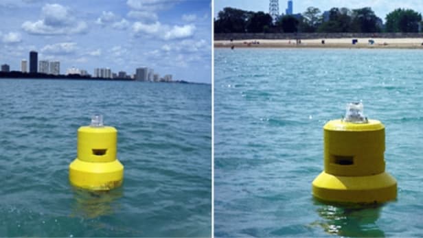
Is the water in your local lake clean enough to swim in today? Currently, the only way to find out is for someone to take a water sample, bring it back to a lab, then report the analysis 24 to 48 hours later. Soon, however, water-sampling buoys anchored off of beaches could provide readings in real time.
Tag Archive for Water
Buoys warn swimmers of dirty water
Minimizing water use, maintaining productivity
As the climate warms up, more and more farmers in Switzerland need to irrigate their crops. This is problematic because many rivers carry less water. If the increase in water use is limited, agricultural production will not be significantly lowered. This conclusion was reached on the basis of models created in a project of the National Research Programme “Sustainable Water Management” (NRP 61).
Lost City Shicheng found Underwater in China
Qiandao Lake, a man-made lake located in Chun’an County, Zhejiang, China, formed after the completion of the Xin’an River hydroelectric station in 1959. 1,078 large islands dot the lake and a few thousand smaller ones are scattered across it. The lake covers an area of 573 km² and has a storage capacity of 17.8 km³. The islands in the lake cover about 86 km²
Will the Aral Sea come back?
This video was prepared by Toprak – Su – Enerji (Soil – Water – Energy) Study Group in Turkey. The video consists of sections of interviews with the local community and representatives during a journey to the Aral Sea Basin in May 2011. Existing situation of the water problem of the Aral Sea is described and key suggestions for the solution are given in the video.
As a result of the studies carried on for saving the Aral Sea, the North Aral Sea partially came back and water level reached to 42 meters. After the completion of the second phase of the project, water level will increase to the level of 46 meters. But, the Aral Sea will not reach to the level of 53 meters in 1960s. Solution for the South Aral Sea seems to be difficult. The South Aral Sea is almost completely dried up and and remaining water level is at 29 meters. Read more
Did you know…? Facts and figures about Estonia
- Estonia’s annual average surface water availability is 12 billion m3 and the groundwater potential is 3.2 billion m3.
- The rivers are characterized by short flow distances and low flow rates. Only 10 rivers are longer than 100 km. The longest is the Võhandu (162 km) and the largest is the Narva, with a catchment area of 56,200 km2, only about one-third of which is within Estonia.
- Of Estonia’s approximately 1,200 lakes, half have a surface area of less than 0.03 km2. The largest, Lake Peipsi, covering some 3,500 km2, is the fourth largest lake in Europe. It was the subject of in-depth case studies in the first and second editions of the World Water Development Report. Read more