
Section 2. Water management situation in the Aral Sea basin
2.1. Water-Management Situation in the Amu Darya and Syr Darya River Basins
2.1.1 Water Resources
In 2025, the total annual natural (unregulated) runoff in the Amu Darya (large basin) and Syr Darya river basins amounted to 108,31 km3.
Amu Darya River Basin
The total annual unregulated runoff of rivers within the larger Amu Darya basin (Vakhsh, Panj, Kafirnigan, Surkhandarya, Кunduz, Kashkadarya, Zarafshan, as well as the rivers of Turkmenistan and northern Afghanistan) reached 75,06 km3. At the “Nominal Kerki” gauging section (located upstream of the intake to the Garagumdarya Canal), the natural (unregulated) flow of the Amu Darya amounted to 64,42 km3, including 7,52 km3 in the first quarter, 50,30 km3 during the growing season, and 6,60 km3 in October – December.
As of January 1, 2025, the combined water storage in the Nurek and Tuyamuyun reservoirs amounted to 14,38 km3.
Syr Darya River Basin
For the Syr Darya River basin, the total annual unregulated runoff, including the Naryn, Karadarya, and Chirchik rivers, as well as smaller rivers, amounted to 33,25 km3, of which 19,72 km3 was the total inflow to three reservoirs, such as Toktogul, Andijan, and Charvak.
By January 1, 2025, the total storage of reservoirs within the Syr Darya basin was 21,35 km3 (Toktogul, Andijan, Bahri Tojik, Charvak and Shardara reservoirs), including 13,64 km³ in the major reservoirs of the flow formation zone — Toktogul, Andijan, and Charvak reservoirs.
2.1.2 Operation of Reservoir Hydrosystems
The annual inflow to the Nurek reservoir from the Vakhsh River amounted to 21,15 km3, including 17,22 km3 (81%) during the growing season. Annual water releases from the reservoir totalled 21,14 km3, including 13,57 km3 during the growing season.
The annual inflow to the Tuyamuyun Hydrosystem amounted to 20,39 km3, falling short of the forecast by 0,23 km3; inflow during the growing season totalled 15,15 km3. Annual water releases from the reservoir reached 21,61 km3, or 98% of the BWO Amu Darya’s schedule, including 15,35 km3 (96%) during the growing season.
The annual inflow to the Toktogul Reservoir from the Naryn River amounted to 12,33 km3, including 9,12 km3 during the growing season (or 74% of the annual inflow). Annual water releases from the reservoir totalled 13,97 km3, including 6,15 km3 (44 %) during the growing season. The Toktogul Reservoir was emptied by 1,71 km3, and its storage reached 9,48 km3 by the end of the year.
2.1.3 Water Allocation and Water Shortage
The allocation of water resources within the smaller Amu Darya basin (Vakhsh, Panj, Kafirnigan, and Amu Darya rivers) and in part of the Syr Darya river basin (Naryn ad Syr Darya rivers up to the Shardara reservoir) among the Central Asian countries is carried out by the ICWC on the basis of limits/quotas established. Below we show an analysis of actual water allocation.
Amu Darya River Basin
In 2025, water withdrawal in the smaller Amu Darya river basin against an established limit of 55,74 km3 amounted to 48,62 km3, including 34,20 km3 during the growing season. The annual limit was utilized by 87%, including - 86% during the growing season. By country, the actual water withdrawal was distributed as follows:
• Tajikistan — with a limit of 9,98 km3, actual withdrawal amounted to 8,27 km3;
• Turkmenistan — with a limit of 22,07 km3, actual withdrawal amounted to 20,57 km3;
• Uzbekistan — with a limit of 23,69 km3, actual withdrawal amounted to19,78 km3.
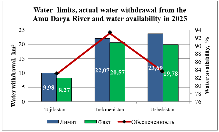
During the growing season, in the reach from the Nurek HPP to the Tuyamuyun Reservoir (Darganata gauging station), the water shortage amounted to 17% for Tajikistan, 1% for Turkmenistan, and 10% for Uzbekistan. In the reach from the Darganata gauging station to the Samanbay gauging station, Turkmenistan and Uzbekistan received 25% and 23% less water, respectively, than the required amount (limit).
Syr Darya River Basin
The total water withdrawal in the Syr Darya River basin (Naryn and Syr Darya rivers up to the inflow to the Shardara Reservoir) amounted to 13,33 km3, including 9,3 km3 during the growing season, which corresponds to 78% of the water withdrawal limit to canals. Discharge from the Syr Darya River to the Arnasay Lake System increased and totalled to 1,8 km3 (compared with 0,7 km3 in 2024).
The BWO Syr Darya’s plan for water withdrawal was fulfilled by 83%. In the reach from the Toktogul to the Shardara reservoirs, the water shortage amounted to 24% for Tajikistan, 29% for Kyrgyzstan, and 29% и 20% for Kazakhstan and Uzbekistan, respectively, during the growing season.
2.1.4 Inflow to the Aral Sea Region
In 2025, according to the Committee for Regulation, Protection and Use of Water Resources of the Kazakhstan’s Ministry of Water Resources and Irrigation, the inflow into the Northern Aral Sea from the Syr Darya River amounted to 1,77 km3.
0,977 km3 of water was delivered to the South Aral region from the Amu Darya River (Samanbay gauging station), while the total inflow, including river water, collector–drainage water (СDW), and discharges from canals, amounted to 2,29 km3.
Based on research , the South Aral region shall receive at least 8 km³ of water from the Amu Darya River in wet years and at least 3.5 km³ in dry years. However, actually, in 2025, 2,29 km3 was delivered to the South Aral region.
2.1.5 Meeting Water Demands
The Table below illustrates how water demands were met for the Central Asian states during the growing season.
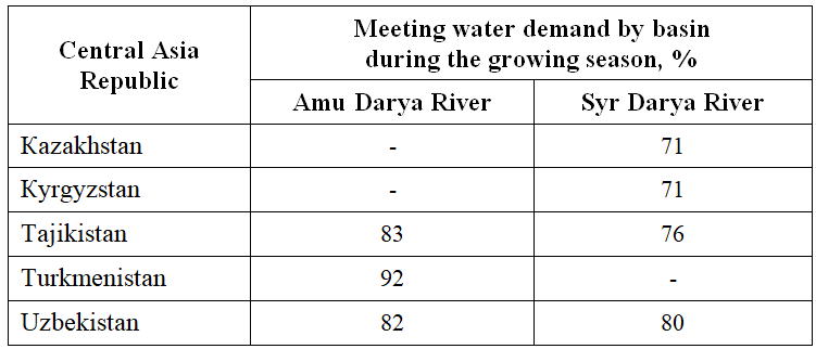
Source: SIC ICWC, according to data from BWO Amu Darya and BWO Syr Darya
2.2 Large Aral Sea and the Amu Darya delta
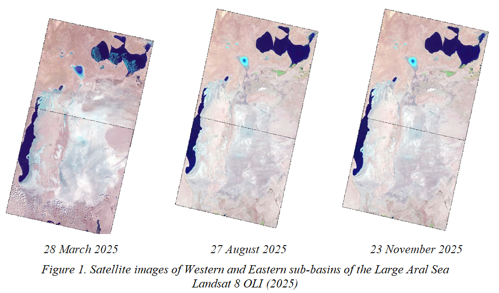
This Section was prepared using the data of BWO Amu Darya, the Aral Sea Region Delta Authority, the Uzbek Hydrometeorological Service (UzHydromet), and based on the RS-monitoring of Eastern and Western sub-basins of the Large Aral Sea (LAS) and the lake systems of the Amu Darya River delta using the Landsat 8, 9 OLI images (http://cawater-info.net/aral/data/monitoring_amu.htm). For the satellite imagery analysis, the NDVI with the refined threshold values was used, allowing the identification of three surface categories: (1) open water surface, (2) wetland, and (3) dryland.
Satellite images of the Aral Sea for 2025 are shown in Figure 1.
2.2.1. Water supply to the Amu Darya Delta and the Large Aral Sea
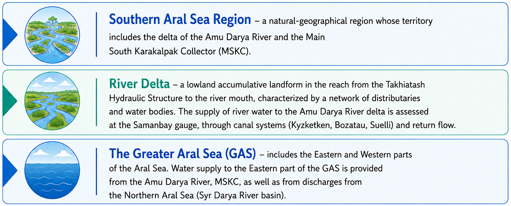
The South Aral Sea region is a natural geographical region encompassing the Amu Darya River delta and the Main South Karakalpak collecting drain (SKCD).
A River delta is a low-lying, accumulative landform extending from the Takhiatash hydroscheme to the river mouth, characterized by a network of distributaries and bodies of water. River water inflow into the Amu Darya delta is assessed at the Samanbay gauging station, the canal systems (Kyzketken, Bazatau, Suelli), and through CDW.
The Large Aral Sea includes the Eastern and Western sub-basins. Water supply to the Eastern sub-basin is provided by the Amu Darya River, SKCD, as well as the discharges from the North Aral Sea (the Syr Darya River basin).
Water Supply to the Amu Darya Delta
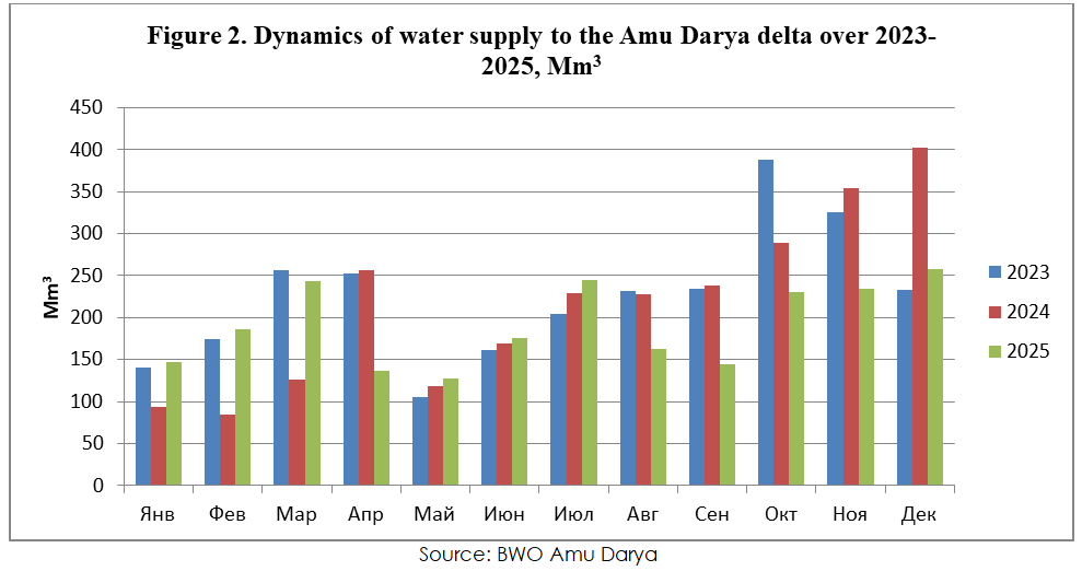
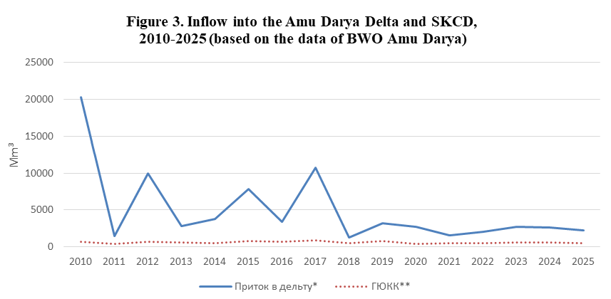
According to BWO Amu Darya, in 2025, 2291 Mm3 of water (including river water and water discharges from canals and collecting drains) reached the Amu Darya River delta. This is 297 Mm3 less than in 2024, and 419 Mm3 less than in 2023. The monthly water supply to the Amu Darya River delta over 2023-2025 is shown in Figure 2.
Dynamics of water supply to the Amu Darya delta over 2023-2025, Mm3
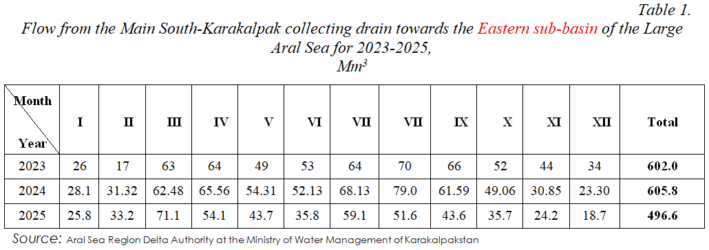
Water flows towards the exposed bed of the Large Aral Sea from the Main South-Karakalpak collecting drain
Bypassing the Amu Darya River delta, 496,6 Mm3 of collector-drainage water flowed from the SKCD towards the exposed bed of the LAS in 2025 (Table 1). This is 109,3 Mm3 and 105,4 Mm3 less than in 2024 and 2023, respectively.
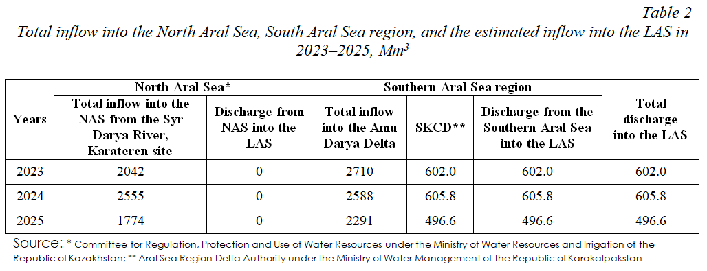
Total inflow into the Large Aral Sea (LAS)
In 2025, 496,6 Mm3 water flowed into the LAS only from the SKCD. No water was discharged from the Amu Darya River delta and the Northern Aral Sea (NAS) to the LAS (Table 2).
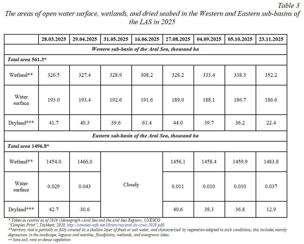
2.2.2. Open Water Surface and Wetland Areas in Eastern and Western Sub-basins of the Large Aral Sea
As RS data show, from March to November 2025, the water surface area in the Western sub-basin of the LAS decreased from 193,0 to 186,6 thousand ha, while in the Eastern sub-basin of the LAS it increased from 0,029 to 0,037 thousand ha (Table 3).
2.2.3. Lake systems of the Amu Darya Delta
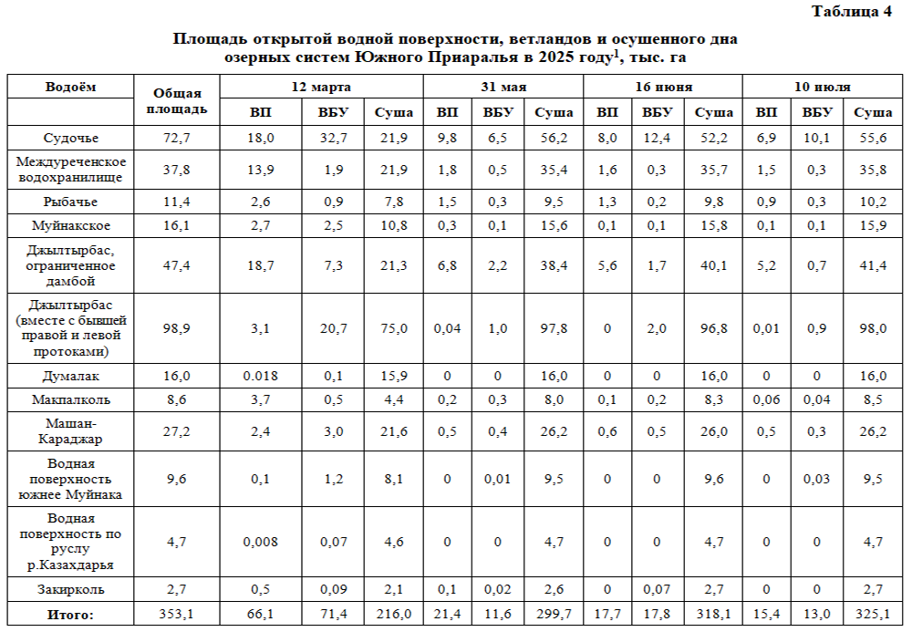
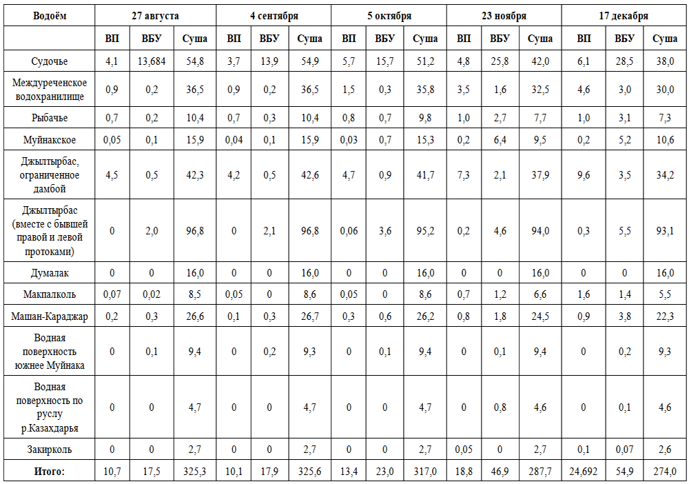
Throughout the year, there is an overall reduction in the water surface area. From March to December, the open water surface area shrank by more than 2,5 times: from 66,1 to 24,6 thousand ha. The most intense decline was observed in the spring–summer period: by September, the area had decreased to 10.1 thousand ha. In the following months, a partial recovery was recorded: from October to December, the area increased from 13.4 to 24.6 thousand ha. This is caused by limited inflow into the Amu Darya River delta, leading to a significant reduction in the water surface area during summer period and its partial recovery in autumn–winter period (Table 4).
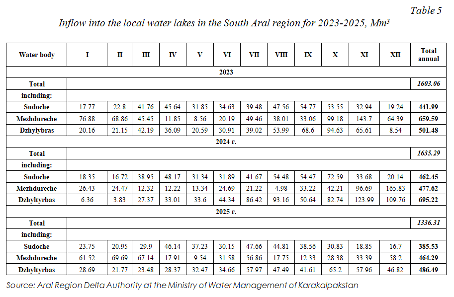
In 2025, the inflow of collector–drainage waters into local reservoirs of the Southern Aral Sea Region (Table 5) decreased compared to 2024: from 1,635.29 to 1,336.31 Mm³, also caused by a reduction in water supply to the Amu Darya River delta.
Conclusion
In 2025, the water management situation in the Amu Darya River delta and the LAS water area was characterized by a decrease in water availability and a continued reduction of water surface. The water supply to the Amu Darya River Delta reached 2291 Mm³, which is lower than in previous years; at the same time, the volume of drainage waters from the SKCD towards the LAS also decreased.
RS monitoring recorded a reduction of water surface area of the Western sub-basin of the LAS and minor changes in the Eastern sub-basin. Simultaneously, a reduction in the water surface area of the lake systems in the South Aral Sea region was recorded, especially during summer period, caused by reduced water supply and high evaporation rate. The total volume of inflow into these water bodies also decreased compared to the previous year.
Overall, the situation confirms the high dependence of the South Aral Sea region and the LAS on interannual water availability and river flow regulation. The water supply of 2291 Mm³ to the Amu Darya River delta remains insufficient to sustain the functioning of Sudoche, Rybache, Dzyltyrbas, and Muynak lakes, as well as their fishery and ecosystems.
In this context, there is an increasing need to improve water management mechanisms, taking into account environmental requirements and ensuring the minimum necessary water releases to the water bodies of the Southern Aral Sea region and the Eastern sub-basin of the Large Aral Sea.

Development and support
Scientific-Information Center ICWC