

Degradation of the Aral Sea and South Prearalie
Though the Aral Sea desiccation is attributed to the Soviet State as the main initiator of this natural-anthropogenic disaster, the concept of sacrificing the Aral Sea for the sake of irrigation and agriculture development actually belonged to scientists of the pre-Soviet period. In particular, A.I. Voyejkov (1908) insisted that under effective agricultural practice in the region the Aral Sea existence is absolutely not justified, since economic effect of its existence (fishery and navigation), in his opinion, is much less than the effect of economic development, especially, irrigated agriculture.
The same idea emerged in 1913 in the mind of another person, not a scientist, but the head of the water sector in the former tsarist Russia, the Director of the Land Improvement Department, Prince V.I. Masalsky. He considered that a final goal was “use of all water resources of the region and creation of new Turkestan…, developing million hectares of new lands and providing cotton demanded for Russian industry… ”.
In Soviet times, irrigation development initiated by the Russian Government progressed greatly. However, till 1960 water diversion for irrigation was accompanied by development of drainage networks and, naturally, by increase of return water released into rivers that exerted little impact on river deltas and the sea.
Quasi-equilibrium of water and salt balances of the sea is typical for the period of 1911 to 1960. About 25.5 million metric tons of salts annually entered the sea; the basic part of this salt discharge underwent sedimentation with mixing of marine and river waters due to over-saturation of the Aral Sea water by calcium carbonate and was precipitated at shallow waters in bays, bights, and infiltration lakes situated along northern, eastern, and southern coastlines. Due to freezing and melting of the sea, a mean salinity in that period varied over the range of 9.6 to 10.3 percent. Relatively high annual river discharge (approximately 1/19 of the sea water volume) gave a peculiar salt composition of the Aral Sea water with a high concentration of carbonate and sulfuric salts, which differed from salt composition of other inland seas.
The modern period of the Aral Sea, since 1961, may be described as the period of active anthropogenic impacts on its regime. Drastic increase of irretrievable river water withdrawal (which amounts to 70-75 km3/year in recent years), exhaustion of compensating abilities of the rivers, and natural aridity in 1960 to 1980 (92 percent) resulted in disequilibrium of water and salt balances. The considerable exceeding of evaporation over the sum of all inflow constituents was typical for the period of 1961 to 2002. The river water inflow into the sea has decreased in 1965 up to 30.0 km3/year; in 1971-1980, it amounted to 16.7 km3/year, on average, or 30 percent of mean annual runoff, and over the period since 1980 till 1999 it made up 3.5 to 7.6 km3/year or 6 to 13 percent of the mean annual runoff. During some dry years, runoff of the Amu Darya and Syr Darya rivers has not actually reached the sea.
River water quality has also changed owing to increase of share of highly saline waste and drainage water that resulted in a significant increase of salinity and deterioration of river sanitary conditions. During dry years, the mean annual salinity of the Amu Darya water entering into the sea reaches 0.8-1.6 g/l, and salinity in the Syr Darya amounts to 1.5-2.0 g/l. In some seasons, higher salinity levels are observed. As a result, in spite of decrease of annual river runoff by 46 percent over the period of 1961 to 1980, the annual salts entry has decreased only by 4 million metric tons or by 18 percent for the same period. Other constituents of the salt balance have also substantially changed. Due to decrease of carbonates content in the river inflow, sedimentation of salts under mixing of river and marine waters was reduced by two times.
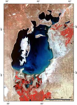
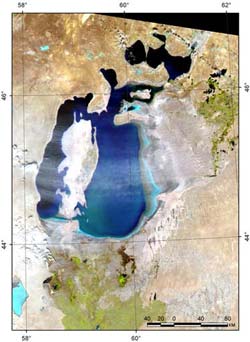
As a result, since 1961 the sea water level has steadily dropped. The total sea level drop, in comparison with the average annual value (prior to 1961) has reached 12.5 m by the beginning of 1985. The average annual rate of the sea level dropping was about 0.5 m, reaching 0.6-0.8 m/year in dry years. The annual sea level fluctuations were also changed. At present, the annual sea level rise is practically not observed, at best, it does not change in winter, and in summer an abrupt drop takes place.
The gradual drop in the sea water level has considerably exceeded predicted rates. Modeling carried out by the State Institute of Oceanology (Dr. V.N. Bortnik) in 1983 has predicted that by 1990 the sea water level would reach 41 to 42.5 m + BSL at probability of 90 percent, and by 2000 - 35.5 to 38.5 m + BSL. In fact, as Table 1-2 shows, by 1990 the sea water surface elevation was 38.24 m +BSL, and by 2000 – about 34 m +BSL. Similarly, seawater salinity has increased at higher rates - by 1990 it was 32 percent instead of predicted 26 percent, and by 2000 it was 40 percent instead of predicted 38 percent.
It was established that saturation of the Aral Sea water with calcium sulfate and precipitation of gypsum occur at the salinity level exceeding 25 to 26 percent. However, the most intensive precipitation of gypsum takes place at the salinity level higher than 34 to 36 percent. Under these conditions, in the winter period in parallel with precipitation of gypsum, precipitation of mirabilite occurs, the latter being of the greatest risk for the Prearalie environment. Dehydrated ammonium sulfate is exposed to wind erosion and can be easily transferred far apart.
The sea level drop and water salinization have resulted in an increase in the amplitude of annual temperature over an all water column and in some shift in phases of the temperature regime. Modification of winter thermal conditions is the most important factor for the biological regime of the sea. Further lowering of a freezing point and modification of the autumn-winter convection mixing process under transition from brackish to high saline waters cause intensive cooling of all sea water mass to very low temperatures (-1.5 to - 2.0о С). This is one of the main factors restricting implementation of acclimatization measures and hindering rehabilitation of fishery in the sea in the nearest future. Lowering the sea level may result in rather noticeable modification of ice conditions, and even in moderate cold winters, ice cover of the entire sea water area with a maximum thickness of 0.8 to 0.9 m may be expected. Cooling and freezing of the sea will occur approximately during the same periods of time; however, reduction of its total heat storage will cause more rapid ice spreading. Increase in a mass of ice per unit area will lead to a more prolonged period of ice melting.
Extremely low specific values of biogenic substances inflow into the sea predetermine their low concentrations in seawater, further constraint for development of photosynthetic processes in the sea, and its low biological productivity. Deteriorating of the oxygen regime of the sea in summer owing to decrease in photosynthetic production and intensive oxygen consumption for oxidation of an organic substance causes formation of oxygen deficit zones and kill phenomena.
Further salinity increase causes both reduction of species of phyto- and zooplankton, phyto- and zoo benthos, and appropriate reduction of their biomass resulting in further degradation of food resources for aquatic life. The existence of endemic fauna is impossible owing to increase in the Aral Sea water salinity.
Quantitative assessment of anthropogenic factors affecting the current water regime of the Aral Sea was carried out by means of calculation of reconstructed values of sea levels and salinity for the period of 1961 to 1980 using the values of reconstructed conditional-natural inflow into the sea. According to these calculations, more than 70 percent of current sea level lowering and of salinity increase are caused by the anthropogenic impact, the rest of these changes are implication of climatic factors (natural aridity).
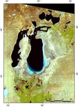
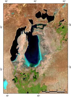
Major consequences of the Aral Sea shrinkage, apart from the decrease of its water volume and area, increase in water salinity and modification of salinity pattern is the formation of a vast saline desert with the area of almost 3.6 million ha on the exposed seabed. As a result, a huge bitter-saline lake and a vast saline desert located at the interfaces between three sand deserts have replaced the unique freshwater water body.
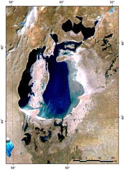
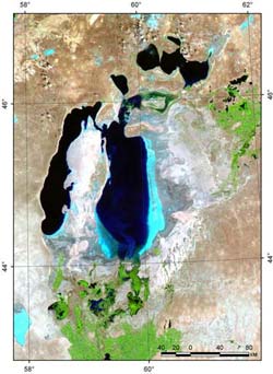
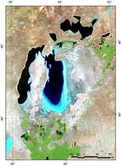
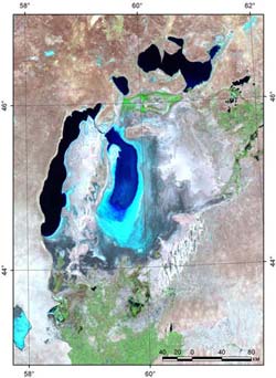
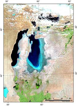
In 1985-1986, the Small Aral Sea completely separated from the Large Aral Sea at the sea water level of 41 m + BSL. This resulted in formation of a new desert area of 6,000 sq km with a salt storage in the top layer up to 1 billion metric tons. Currently, precipitation of gypsum from the saturated marine water is under way. At the sea level of 30 m + BSL (total drop is 23 m) the western part of the deep-water Large Aral Sea will be separated from the eastern shallow part by islands.
After separation of the Small Aral Sea from the Large Aral Sea, their regimes started developing according to different scenarios. Since the Syr Darya River inflow has been higher than the Amu Darya river inflow, the Small Aral Sea level started rising and water salinity decreasing. A break in the Small Aral Sea temporary dam caused the water level to lower; however, previous filling has proved the correctness of the decision to create the separate Small Aral Sea at the elevations of 41 to 42.5 m + BSL. The developed project of an engineered dam, with a regulated spillway in the Berg’s Strait, will provide the possibility of establishing a sustainable ecological profile of this water body and its environment.
Thus, the Aral Sea has transformed from being an integral water body in the past into a series of separated water bodies each with its own water-salt balance and own future depending on what policy will be selected by five countries that are economic entities of these river basins.
Characteristics of Prearalie habitat degradation under impacts of the sea desiccation are presented in the paper “Assessment of Socio-Economic Effects in Result of Ecological Disaster – Aral Sea Desiccation” prepared within the framework the INTAS/RFBR-1733 Project (August 2001), and published by the SIC ICWC (Tashkent). Summary of the basic degradation effects are given below:
- decrease of lakes’ area in the Amu Darya delta from 400,000 ha in 1960 to 26,000 ha;
- groundwater table lowering up to 8 m depending on the distance from the sea coast,;
- erosion of river channels and their beds incision up to 10 m;
- development of salt and dust transfer within the belt of 500 km wide with load capacity of 0.1-2.0 t/ha;
- top-soil changes: an hydromorphous soil area reduced from 630,000 to 80,000 ha;
- the area covered by solonchak increased from 85,000 to 273,000 ha;
- the reed growth area reduced from 600,000 to 30,000 ha;
- the tugai forest area reduced from 1,300,000 to 50,000 ha;
- climatic changes in the zone of 150 to 200 km from the sea;
- fish catch decreased from 40,000 to 2,000 metric tons per year.
All these affects have resulted in economic losses amounting to US$115 million and social losses estimated in the amount of US$28.8 million annually.
It should be noted that ecological changes related to the sea desiccation have been accompanied by water inflow reduction and, consequently, deterioration of potable water supply (increase in salinity and decrease in groundwater inflow). This fact, in turn, has caused a growth of sickness rate of the population. It was clearly demonstrated by Dr. O. Ataniyazova and others (Nukus, 2001) in their paper “The Aral Crisis and Medical-Social Problems of Karakalpakstan”.
In the early 1970s, when the Aral Sea started rapidly shrinking, the Public of the former USSR arrived at an understanding of the need to undertake some reclamation measures. At that time several governmental commissions were established. They have concluded that it is necessary to undertake urgent measures if not on cessation of the sea level lowering, then at least, on mitigation of negative socio-economic and ecological impacts related to this disaster. Transfer of Siberian rivers’ water in the amount of 18-20 km3 annually was proposed to improve water supply and concurrently environmental conditions in the Prearalie. The government of the USSR rejected this proposal in 1986 and submitted a range of alternative measures approved by the Resolution No 1110 of 1986. Eventually, two BWOs “Amu Darya” and “Syr Darya”, a special organization “Aralvodstroy”, and the coordinator of the program - the Consortium “Aral” were established. During the period of 1987 to 1990, a certain scope of works related to water conservation improving in the South Prearalie, the Right Bank Drain, and completion of the Tuyamuyun Reservoir Project was implemented.
After the collapse of the USSR in late 1991 all these efforts were stopped until the Heads of five Central Asian States have established an International Fund for the Aral Sea in 1993 and on January 11, 1994 they approved the Aral Sea Programme, which includes measures on improving the situation in the South Prearalie. In particular, it was decided “to develop the feasibility study for establishing artificially-inundated landscape ecosystems in the Amu Darya and Syr Darya deltas and areas adjacent to the dried-up Aral Sea bed as well as implementing proper reclamation measures to rehabilitate the natural conditions in this area”. At the same time, the basic provisions of the Concept of Improving Socio-Economic and Ecological Situation in the Prearalie” were approved. These provisions distinctly stated that rehabilitation of the Aral Sea to its original state is impossible, and the main efforts should be placed on construction of necessary water infrastructure and measures related to creation of a new sustainable ecological profile of the South Prearalie by means of proper water supply, afforestation, and other reclamation activities.
This document was actually based on our proposals, which had been published in the “Vestnik Pustyni” magazine No. 3 (1984), to preserve the South Prearalie by creating on its territory the ecologically sustainable zones that will perform those functions, which the two former ecosystems were jointly performing. For this purpose, the South Prearalie, including the delta and the sea itself, is subdivided into ecological zones different according to the forming principles (e.g. fresh, brackish and mixed water supply, etc.).