

Water Resources of the Aral Sea Basin
The water resources in the Aral Sea region consist of renewable surface and groundwater, as well as return water from anthropogenic use (wastewater and drainage water). There are two major river basins located in the Aral Sea Basin: the Syrdarya in the north, and the Amudarya in the south. The Zeravshan river, a former tributary of the Amudarya, has a position between these two major rivers.
Groundwater: reserves and use
The groundwater resources of the Aral Sea basin can be divided into two parts: the natural flow from mountainous and water catchment area and groundwater originated by filtration from hydrotechnical structures and irrigated land. On the whole 339 aquifers were prospected and approved as sources permitted for exstraction within the region. Estimated regional reserves are about 31.17 km3, of which 14.7 km3 are located in the Amudarya basin and 16.4 km3 in Syrdarya basin. Because exploitation of groundwater can have an impact on surface water flows, the quantification of groundwater resources must be careful carried out to identify the portion of the reserves that can be used without significantly diminishing surface runoff. The reserves confirmed for extraction are estimated at 13.1 km3 per year.
Total actual groundwater extraction in the Aral Sea Basin was about 10.0 km3. The quality of groundwater in the region varies by salt content from 1 to 3 g/l. Almost half of the common volume of groundwater is sufficient for domestic needs, and approximately 70% for agriculture. A considerable part (about 30%) of regional groundwater has a transboundary nature, and its usage requires interstate consideration and mutual regulation.
Groundwater reserves and use in the countries within the Aral Sea basin (million m3 per year)
|
Country |
Estimated regional groundwater reserves |
Reserves confirmed for extraction |
Total actual extraction |
Including different users and purposes |
|||||
Domestic water supply |
Industry |
Irrigation |
Vertical drainage wells |
Pumping tests |
Other |
||||
|
Kazakhstan |
1846 |
1224 |
420 |
288 |
120 |
0 |
0 |
0 |
12 |
|
Kyrgyzstan |
862 |
670 |
407 |
43 |
56 |
308 |
0 |
0 |
0 |
|
Tajikistan |
6650 |
2200 |
990 |
335 |
91 |
550 |
0 |
0 |
14 |
|
Turkmenistan |
3360 |
1220 |
457 |
210 |
36 |
150 |
60 |
1 |
0.15 |
|
Uzbekistan |
18455 |
7796 |
7749 |
3369 |
715 |
2156 |
1349 |
120 |
40 |
|
Total Aral Sea basin |
31173 |
13110 |
10023 |
4245 |
1018 |
3164 |
1409 |
121 |
66 |
Waste and drainage water
Return water constitutes a high proportion of water resources in the basin and are also a major source of pollution. In recent years, the annual mean values of return flows, consisting of drainage and wastewater from irrigation, industry, and municipal users have varied between 28.0 km3 and 33.5 km3. About 13.5 to 15.5 km3 annually form in the Syrdarya basin, and about 16 to 19 km3 in the Amudarya basin. The total amount is comprised of about 95% of drainage water and about five percent of untreated domestic and industrial wastewater. The large percentage of drainage water demonstrates that irrigation actually consumes only about 45-50% of total withdrawals.
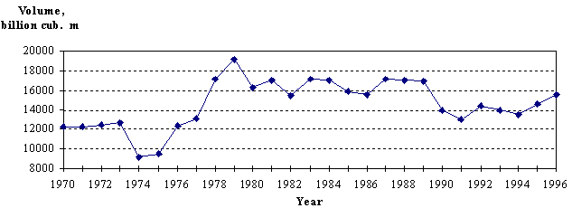
Drainage and wastewater variations in the Syrdarya river basin
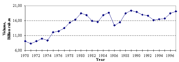
Drainage and wastewater variations in the Amudarya river basin
Drainage water involves two components: The surface component consists of the outflow from irrigated fields, losses from the irrigation network, and water pumping from the vertical drainage system. The subsurface component of these waters consist of infiltration from irrigated fields and the infiltrated water from irrigation networks that reach the collector-drainage system. Minimization of losses is one of the principal goals for water managers. Drainage water is highly saline, from 2 to 3 g/l from April to September, and 5-12 g/l during autumn and winter periods. The quality of the drainage effluent depends on the location of the irrigation scheme within the river basin (upper, middle, or lower reaches) and the leaching requirements of the irrigated area. It also depends on the use of agro-chemicals. The local salt mobilization is determined in part by the type of the drainage system (open, subsurface or vertical), seepage, drain spacing, and drain depth. The poor quality creates limitations for the re-use of drainage water, especially for irrigation. Only about 15% of total return flows are re-used and more than 55% returns to rivers. About 30% end up in natural depressions, from which the water evaporates.
Dams and hydropower
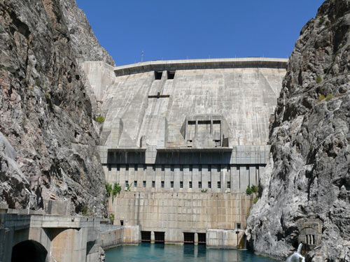
More than 80 water reservoirs were constructed in the Aral Sea basin, each with a capacity of over 10 million m3. In order to modify natural river flow patterns to those needed for water supply, water storage reservoirs were constructed either on rivers (off-stream and river-channel reservoirs) or on main canals (compensation reservoirs). The aggregate capacity of these water reservoirs exceeds 60 km3, of which about 44 km3 is useable, including 17 km3 in the Amudarya river basin and 27 km3 in the Syrdarya river basin.
There are 45 hydropower plants in the Aral Sea Basin with a total capacity of about 34.5 GW, ranging from 50 to 2,700 MW. The biggest hydropower plants are the Nurek (in Tajikistan on the Vakhsh river), with a capacity 2,700 MW, and Toktogul (in Kyrgyzstan on the Naryn river), with a capacity 1,200 MW. Hydropower constitutes 27.3% of average energy consumption in the Aral Sea Basin. The contribution of hydropower to the general energy consumption is the largest in Tajikistan (about 98%) and in Kyrgyzstan (about 75%), and the lowest in Turkmenistan (about 1%). Potentially, the region can meet more than 71% of its energy requirements from hydropower which would equal an output of about 150 GW h.