

Introduction
The main task of this Information System is to develop a common system for accounting land and water resources in the Aral Sea basin, with capability to assess different aspects of their use and prediction efficiency that will facilitate sustainable management and control of water resources use. The Information System is a multi-level, inter-state, inter-sectoral system built on levels of management of water and land resources and related water use objects, as well as on water resources formation and use levels. The emphasis is put on usefulness, reliability and openness of presented information that implies a number of requirements to developed means and tools.
The main component of the Information System is a database designed for centralized storage and control of interrelated pooled data that adequately represent the status of objects in given data domain(s) and relations between them.
The Information System on water and land resources in the Aral Sea basin is designed first to support decision-making process in water sector in Central Asia. The Information System is a practical tool for comprehensive assessment of water situation (available water resources for use and allocation of them among river reaches, provinces and water management systems; operation modes of reservoirs and hydropower stations; water losses, deficits, imbalance, environmental flows, water quality indices and so on), with elements of analysis and suggestion, and a means for dissemination of required data checked and adjusted by the states. It will enable regional and national organizations to transfer to a common “informational language” that will help raise the validity of data being used, and therefore raise the effectiveness of water resources management.
Data validity supposes checking and adjusting them, including by using models, and consistency among the states, when data discrepancy and inaccuracy are reduced to minimum, when data evaluation and prediction is transferred to common methodical basis (calculation of losses and so on).
The Information System provides different levels of access to presented information: every user has his key and can view and correct his information, and also view data characterizing the situation with neighbors, including consequences of his actions.
The Information System enables
To process data from gauging stations:
- Preparing trends for a series of years;
- Comparing water flows over major gauging stations: in low, average and high water years (fact/plan).
To analyze:
- Volumes of water intakes at the Syrdarya and Amudarya river reaches for Central Asian states as a whole as well as for components (large canals, pumping stations) (fact/limit);
- Balances of the Syrdarya and Amudarya river reaches for a series of years – discrepancy and components (fact/limit);
- Balances of reservoirs for a series of years - discrepancy and components;
- Operation modes of waterworks – trends of reservoir water inflows, releases and volumes;
- Water consumption and disposal – Central Asian states as a whole, provinces and planning zones;
- Distribution among agricultural, industrial and municipal water uses;
- Specific water consumption – Central Asian states as a whole, provinces and planning zones;
- Calculating absolute and specific indicators of water consumption and disposal with respect to any year;
- Indicators (water consumption, economics and agricultural production) for Central Asian states and the basin as a whole:
- Population growth;
- GDP;
- Agricultural production;
- Investments in water sector.
To make a comparative analysis of agricultural indicators for Central Asian states and the basin as a whole:
- Percentage of areas under major crops;
- Growth in areas under major crops;
- Growth in total yields of major crops;
- Specific water intake per 1 ton of gross product a year;
- Change in irrigated areas;
- Specific drainage length per irrigated and drained area;
- Percentage distribution of irrigated lands by salinity degree;
- Change in saline lands.
To evaluate losses and specify water balance components (run-of-river and reservoirs) by a program:
- Evaluate seepage losses from major Amudarya and Syrdarya river reaches;
- Evaluate evaporation losses from major Amudarya and Syrdarya river reaches;
- Calculate evaporation and seepage losses from major reservoirs in the region.
- To compare actual water intake in a planning zone with design water consumption, evaluating losses in irrigation system.
The application of model instrument (ASB-mm, etc.) in the structure of the Information System will enable:
- To make a multi-version assessment of water situation;
- To wittingly exclude ineffective decisions;
- To solve problems of information uncertainty.
Finally, to provide a common coherent tool for regional assessment to decision makers.
Priorities of models:
- Represent environmental requirements from the positions of sustainability and future generations;
- Represent regimes based on compromises oriented to equitable flow distribution and minimum losses.
Based on information from the DB and socio-economic block of the ASB-mm connected to the IS, decision makers can find answers to the following questions:
- What are the perspective requirements of diverse economic sectors for water resources?
- Which of the scenarios for future development are the most acceptable to each state and the whole basin?
The heads of irrigation authorities and specialists in water resources planning and management can use the results of model calculations with a view to:
- Looking for sites and links characterized by ineffective water flow use, excessive water intake, disproportionate water allocation;
- Developing effective plans for water allocation among diverse users and reaches;
- Looking for ways to save water and improve water efficiency.
The Water-Energy block of the Information System together with models will make it possible to carry out assessment of actual and planned operation modes of hydropower stations, along with cost analysis.
Such analysis shows benefits and damages from flow regulation by large multipurpose waterworks and their cascades (Toktogul, prospective hydropower stations and so on) in the sectors (energy, irrigation) in the states.
Diverse initiatives and alternatives of the riparian states and diverse schemes for introducing price for flow regulation may be lost, and joint actions of the states in reaching a water-energy consensus may be developed.
At that, consequences of irrigation-energy regimes of hydropower stations in lower river reaches are evaluated (forced releases to Arnasay, restrictions on releases at the downstream Chardara reservoir, adjustment of water intake volumes).
When the Information System is used properly and purposefully, it can be one of important elements of interstate cooperation in water resources management. The introduction of the Information System will enable to strengthen the existing information relations of the ICWC and its executive bodies, as well as inform Central Asian states in regard to water sector and environment in the Aral Sea basin.
About Information System
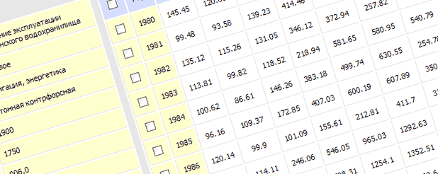
Information System is divided into some blocks: "Land", "Water", "Economy", "Hydropower". It contains reliable information related to water management (e.g. land resources, water & power parameters, economic indexes etc.). Existing database is effective support system of users interested in appropriate information. This database contains data on 150 parameters, including 90 parameters from 1980 up to present time.
Registration and access to data
Registration is very simple and takes a little time.
Every newly registered user may evaluate the Information System (IS). In this case access (on default) to information on some parameters (1980-2000) is limited, but information on other parameters (from 1980 to present time) is fully accessible. This rule is applicable to all countries and areas belonging to the Aral Sea Basin.
To be eligible for using information for period from 2000 up to present time (as well concerning countries) the registered user has to send the request about information he/she needs and for what aim. After receiving permission from administrator the needed access to Information System will be open.
Metadata
Coverage Area
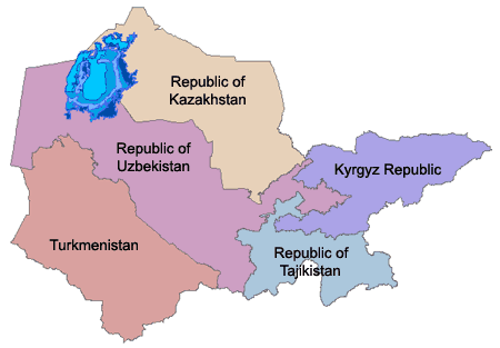
Information System covers areas within countries in the Aral Sea Basin:
Republic of Kazakhstan
- Kzylorda
- South-Kazakhstan
Kyrgyz Republic
- Jalalabad
- Naryn
- Osh
Republic of Tajikistan
- Khatlon
- Sughd
- Region of Republican Subordination
- Gorno-Badakhshan
Turkmenistan
- Dashkhovuz
- Mary
- Lebap
- Akhal
Republic of Uzbekistan
- Andijan
- Bukhara
- Djizak
- Kashkadarya
- Navoi
- Namangan
- Samarkand
- Surkhandarya
- Syrdarya
- Tashkent
- Fergana
- Khorezm
- Karakalpakstan
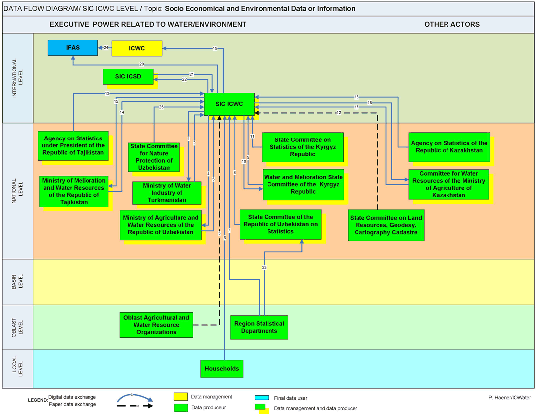
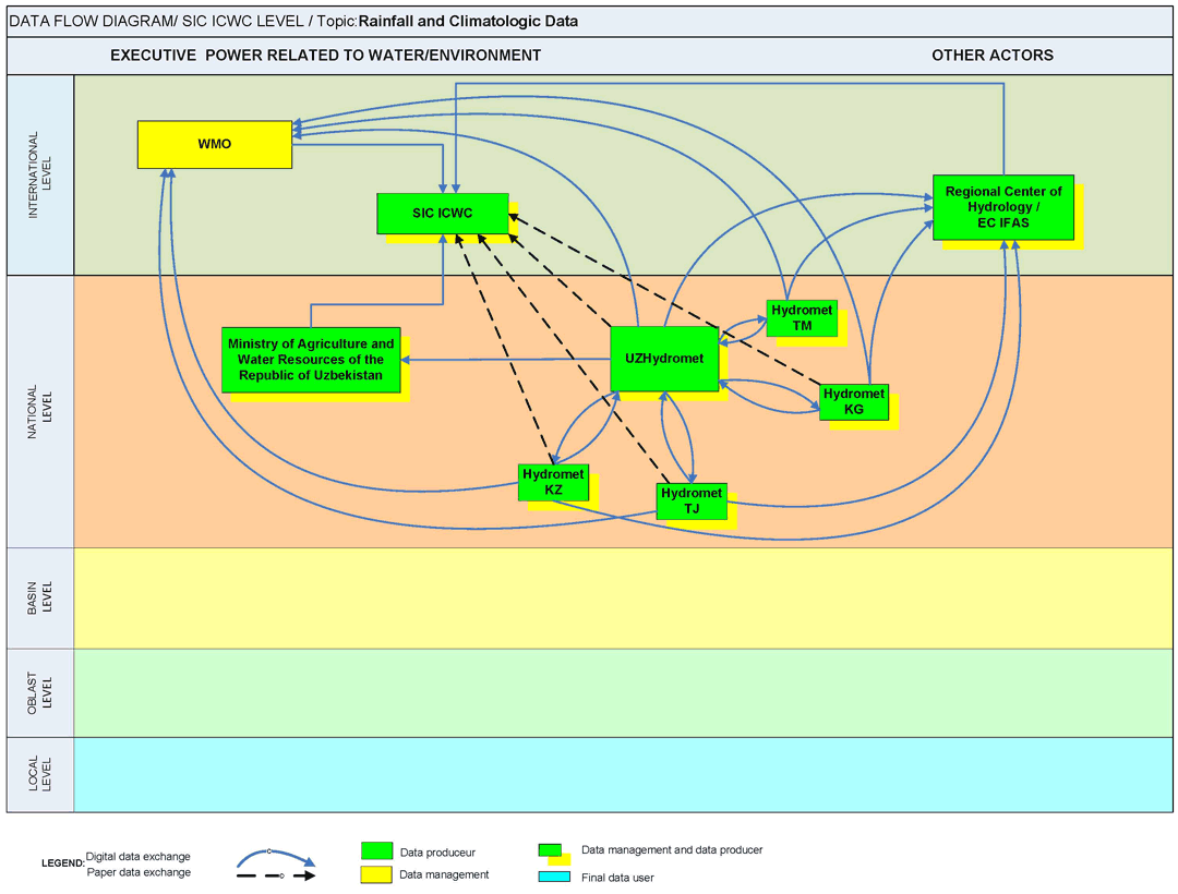
Data Flow Diagrams
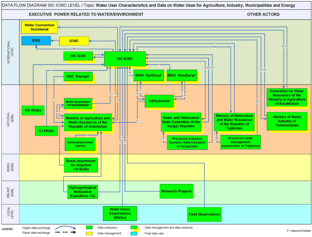
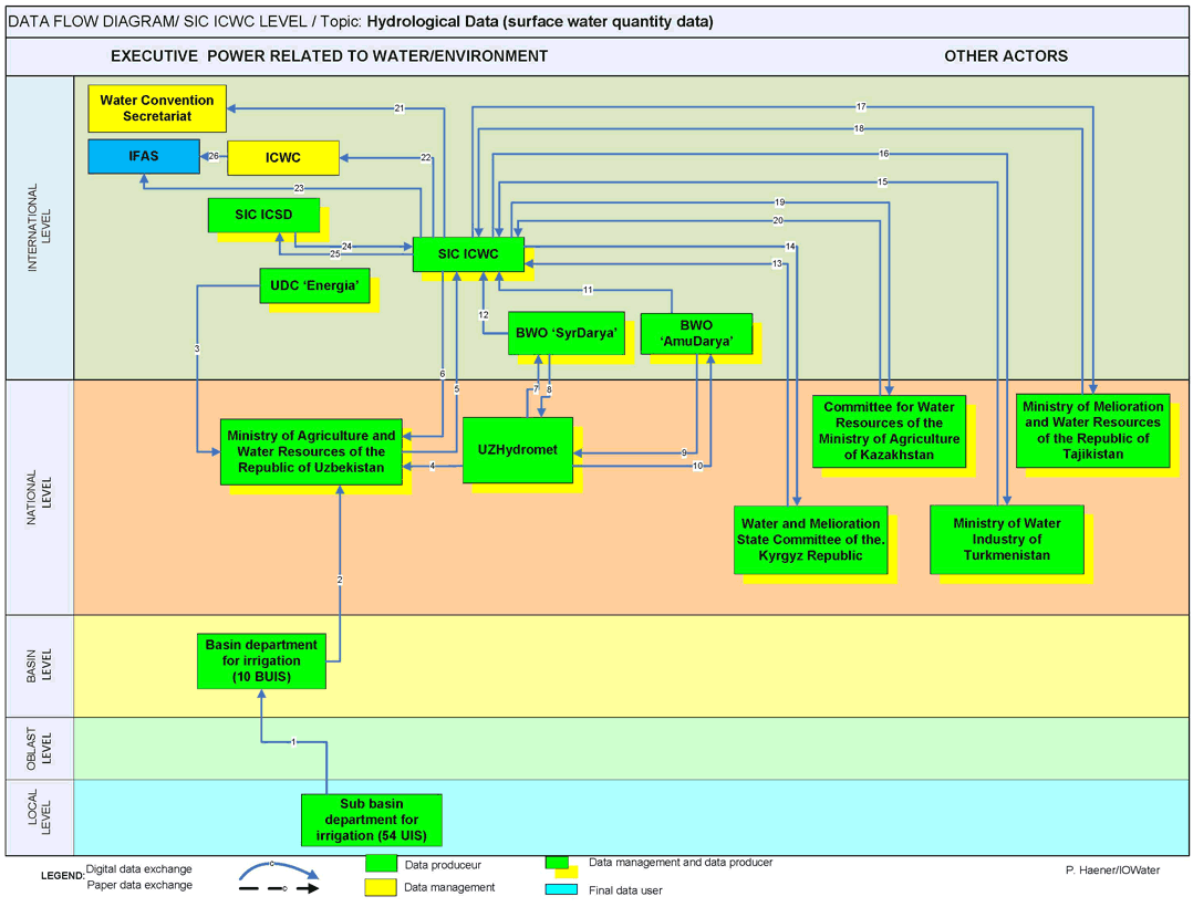
Disclaimer
Access to the Information System is provided to user on the understanding that it is a system still under current and constant improvement.
Data is provided 'as is' and 'as available' for use, without warranties of any kind, either express or implied, including but not limited to those of merchantability or fitness for a particular purpose or representations about the accuracy or completeness of the information in the Information System. User is responsible of ensuring compliance with copyrights and intellectual property rights when he/she reproduces, transmits, displays, copies, distribute or uses data of Information System.
SIC ICWC shall not for any reason whatsoever be held responsible for any damage, loss, cost, claim or expense incurred by users as a result of using data of Information System or their misinterpretation, even if SIC ICWC has been advised of such possibility.