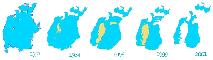
Aral Sea and PrearalieSea desiccation, volume reduction. Irrigated farming development caused water quality and productivity deterioration. Before 1960 Aral Sea area was 66-67 th. km2 and volume 1062 km3 with average salinity10-11g/l, mean depth was 15 m, maximal up to 60 m, sea horizon altitude was 53-54 m.
At that time evaporation was – 60 km3 (100-1200 мм) per year or 1900 mm3/s, precipitation – 6,6 km3 (207 m3/s), surface inflow – 53-54 km3 (1693 m3/s). Irrigated area was 5,1 mln.ha. Since 1960 with development of new irrigated lands and reclamation of old irrigated ones attracted river additional flow. By 1995 sea level has fallen down to 37 m, water volume to 285 km3 and aquatic surface reduced to 33 th. km2, water salinity exceeded 30 g/l. Surface inflow to the sea varied within the limits of 3-5 to 20-25 km3 (in humid years). Priaralie deserttification. Desertification process is reflected in climatic factors changes, salinization area increase, salt accumulation in soil, soil degradation due to both sea desiccation and poor irrigation management. By 1995 960-700 km2 were free from water. Loss of fish productivity. By 1995-2000 valuable fish species fishery has been practically stopped due to water volume reduction and water salinity growth up to 30-35 g/l against 10-11g/l in 1955-1966. While in 1960-1965 fish production was 40-45 th.t. Climate dryness strengthening. Aral Sea desiccation led to climatic changes:
Salt and dust transportation from dry sea bed. Under wind activity strengthening salt and dust are transported on irrigated lands. Their volume is 100-130 mln.t and tyrasnfer distance is 500 km (strong influence on 150-300 km). Groundwater inflow increase. Before 1960 under sea aquatic surface 1064-1085 km2 sea created backwater for ground water formed in Prearalie. Sea retreat on 250-300 km strengthened ground water inflow to the sea but due to low permeability ground water flow does not provide land drainability for soil water-salt regime management. Social-economic damage. Damage to economic branches linked with the sea is as follow:
Delta losses and degradation. Irrigation influence on delta degradation is expressed in excessive water diversion, that reduces water supply to the delta and, as a consequence, channel depth decrease, flood plains desiccation and vegetation deterioration. These processes lead to soil cover and land fertility degradation. Example of that are Amudarya and Syrdarya deltas. |