Сlimatic characteristics of the Aral Sea basinAral Sea basin located in the center of Euroasia encompasses sub-tropic and temperate zone. Climate is continental because of region location within deserts and its remoteness from seas and oceans. Main climatic features-heat, humidity deficit, long hot summer and short warm winter. Central Asia territory is divided into natural belts, zones and province. According to soil-geographic zoning two climatic belts are distinguished: sub-boreal and sub-tropic. Border between these belts is 430 of northern latitude (south coast of Aral sea). This border can be called conditional, i.e. climatic. There are sub-boreal and sub-tropic desert land-scapes, in pre-mountain plains sub-boreal desert steppe and sub-tropical semi-desert land-scapes.
Peculiarities of air temperatures in the regionAir temperature peculiarities in the region within the Central Asia deserts average temperatures and duration of frost free period increase from the North to the South. Number of months with positive temperatures is 11-12 in the South and 7-8 in the North. Duration of frost free period in Kzyl Atrek is 271 days, in Karakala - 236, in Termez and in Bairam Ali - 212 days while in northen deserts its duration is 150-190 days. Within growing period (with average temperatures more than 10 oC) sum temperatures is 4500-5600 oC in the South and only 3200-4000 o in the North. Maximum high temperatures areobserved in the South (48-49 oC, Karakum and Kzylkum and minimum ones - 36 oC in the North.
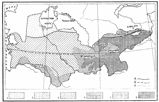
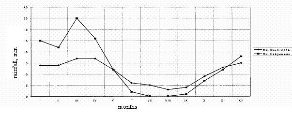
Fig. Natural-climatic zoning of the Aral sea basin Rain fallRain fall occurs mostly in winter-spring period, its value is 90-450 mm/years on plains and 1000-1500 m/years in the mountains. Relative air humidity in summer is 27-35 %, in Karakum desert sometimes it is 4-5 % and near the Kaspian sea - 50 %. Maximum air humidity is observed in December-January, minimum - in June
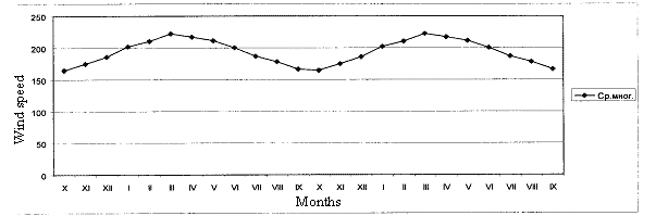
Fig. Season changes of rainfall for south and north zones of the region according to multi-year data Under hydromorphous regime evaporation value (Er) significantly exceeds total pre-cipitation (by 1,26-4,55 times) due to ground water evaporation. Water regime of hydromor-phous soil intensity varies under ground water <3,5 m from 0,35 to 3,55 of total rainfall. Low precipitation rate and high evaporability lead to small and shallow soil moisten-ing and preservation of salt stock within upper 1 m layer. Higher moistening is typical for pre-mountain plains. On hydromorphous landscapes differences between sub-boreal and sub-tropical de-serts are very evident. Ground water critical depth varies from 250 cm in the north to 300 cm in the south, evaporation rise, in sub-tropic desert evaporation from ground water table depth of 1 m is 1,7 times higher compared with sub-boreal. This facilitate perspirative regime of salt accumulation. Thus climatic peculiarities of plains in the Aral sea basin are high heat availability and low natural humidity (aridity coefficient Ka < 0,12-0,30; continentality coefficient Kk = 220-290; dryness index R = 2,5-12). Climatic indicators of the Central Asian plains are favorable for salt stock preservation in automorphous soils on depth of 0,5-1,5 m (due to low air humidity) and lead to salt accu-mulation in hydromorphous soils under ground water depth less than 3-3,5 due to high evapo-rability. Therefore, Central Asia and South Kazakhstan climatic factors predetermine devel-opment of harmful ecological-meliorative processes during land development and reclamation when violating meliorative regime parameters. Wind regimeSpecific feature of arid climate is wind regime. Wind often forms surface of arid land-scapes, especially in sand deserts, strengthens evaporation, promotes eolic salt removal. Aver-age wind speed in coastal zone of Kaspiy and Aral sea is 6 m/c. In the South it fluctuates around 2 m/s, in pre-mountain plains it can reach 34-36 m/s (Golodnaya Steppe). Figure shows that the calmest are September-October, most windy period is Yanyary-May. The region as a whole is zone of moderate winds, last years due to Aral sea desicca-tion wind significance sharply increased. According to assessment of Borovsky (1978) and Orlova (1983) salt removal from dry sea bed can reach 3-5 t/ha per year.
Fig. Seasonal changes of wind speed according to multi-year data (average from 11 weather stations) Thus climatic factors of Central Asia and South Kazakhstan predetermine develop-ment of unfavorable ecological-meliorative processes under land development and irrigation and meliorative regime violation. |