Hydrogeological conditions of main regions of irrigationHydrogeological conditions are complex of indicators characterizing conditions and regularity of ground water formation in natural conditions, expected reclamation inflence and necessary measures providing favorable hydrogeological conditions. With respect to degree of complexity irrigated regions are divided in to 4 groups:
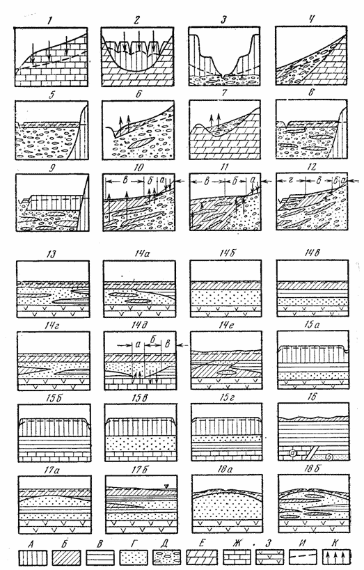
On fig. examples of orogenic and platform regions which are characterized by different complexity of hydrogeological conditions are shown.
1. mountain slopes and pre-mountain plains made of flaky bedrock; 2.
3. deeply corrugated pre-mountain plains; 4. rivers cones of removal; 5. low and middle alluvial terraces; 6. imperfeet river cones of removal; 7. depressions between adyrs; 8. upper parts of sub-aerial delts, middle allu-vial terraces weakly drained; 9. alluvial terraces very weakly drained; 10. cones of removal constituting pre-mountain plains.
Irrigated regions of platform group with respect to hydrogeological conditions com-plexity vary from simple to very complex. Depth of regional impermeable layer is low. Quaternary rocks do not contain gravel-pebble deposits. Regions with relatively simple hydrogeological conditions are characterized by fresh ground water formation with table deep ground water table (regions 1 - 4 on fig.). These regions are located mainly in water sheds and are distingnised by intensive natural drainability. Ground water outflow fully compensates inflow evaporation and transpiration are neg-ligible or absent at all. Automorphous regime of soil formation is typical under this outflow, soils are non-saline (typical and light grey soils, etc.) and sustainable good meliorative state of lands as provided. Artificial drainage is not required that reduces expenses for reclamation. These lands are very favorable for irrigation. Naturally drained lands also belong to the first groups of regions. Thanks to intensive ground water outflow it is sustainably fresh in spite of shallow water table (regions 5,8,on fig.).This is facilitated as well by intensive ground water inflow which, under substantial outflow, provides good "flushing" of deposits and absence of easily soluble salts within unsaturated zone. Thanks to shallow fresh ground water agricul-tural crops cover their water requirement at expense of ground water. Meadow -marshy soils, which are formed under these conditions, possess high potential fertility (in case water log-ging prevention). Soils have sulfate-calcium and carbonate. Magnesium salinity with forma-tion of solid salt horizons (called in Central Asia "shokh or "aryk". Regions of medium complexity include naturally drained lands where under artesian water influence it is necessary to fight water logging more intensive drainage is needed to compare with the first group regions (regions 6,7 on fig.). Weakly drained regions, where it necessary to fight slightly soil salinity, encompass also naturally weakly drained re-gions with saline ground water (regions 9,14, a, b, c, d on fig.). Regions with complex hydrogeological conditions are widely spread within irrigated zone. They are as follow:
In considered group of regions, where ground water of high salinity occures, the main task of reclamation measures is fight with soil salinization on base of ground water regime regulation by the intensive drainage. Regions with very complex hydrogeological conditions include :
Regions of last group require the most intensive drainage to fight with land saliniza-tion and leaching irrigations using chemical meliorants (in case of soil sodification). If in the regions with simple hydrogeological conditions expenses for drainage are not necessary, in considered group of regions these expenses achieve 2-3 th. rouble/ha. Annual operational costs are high as well. For many regions of this group methods of ground water regime regulation for recla-mation are not yet developed. One of the most important hydrogeological indicators of irrigated lands is a natural land drainability. Its indicator is potential value of ground water outflow (expressed in mm of water layer or m3/ha per year). Massif natural drainability is defined by its geostructural, geological, geomorphologi-cal conditions, relief, ground water inter action with surface water bodies and with artesian water as well. These factors are reflected in geofiltration schemes of irrigated or drained mas-sifs. The following geofiltration schemes are possible depending on geology:
Under geofiltration schematization for quantitative characteristic of layer parameters it is expedient to use the following quantitative indicators. Layer permeability with respect to horizontal drainage conditions: Favorable conditions - permeability coefficient more than 0,5 nm/day,intermediate - 0,1-0,5 and unfavorable - less than 0,1 m/day. On base of analysis of drain operation under permeability coefficient less than 0,1 m/day their differentiation is expedient on the following groups: from 0,1 to 0,01 m/day low permeability, from 0,01-0,001 m/day very low permeability and less than 0,001 m/day-extremely low permeability. At the same time along with soil permeability reduction losses for filtration from irrigation canals reduce as well. For assessment of vertical drainage and ground water intakes operation efficiency and common hydrogeological conditions of the massif one of main parameters is sediments water conductivity. Under two-layer of multi-layer scheme water conductivity of more permeable layer should be evaluated within the following borders: less than100 m2/day (unfavorable); 100-200; 200-500; 500-1000; more than 1000 m2/day. Along with water conductivity increase conditions of water-intake and vertical drain-age efficiency are being improved. Important factor of geofiltration schematization is availability and character of links between ground water and under artesian aquifer . It should be distinguished: 1) regions of ground water formation, 2) regions of unit aquifers of ground and artesian waters formation. Under accedance of artesian water head over ground water level and overflow from ar-tesian water to ground one it is expedient to distinguish the areas: weak artesian recharge-up to100 mm/year; middle-from 100 to 200; strong-from 200 to 300; very strong-more than 300 mm/year. Natural drainability depends on factors considered as well as geofiltration flows bor-der conditions. With respect to natural drainability degree certain hydrodynamic zones are distin-guished, characterized by different outflow of ground water compared with its irrigation re-charge. From water balance investigations is found that in arid and semi-arid zones under ex-isting land efficiency and furrow irrigation by dravity, irrigation recharge of ground water is near 300-600 mm/year. Coming from that the following 5 zones are distinguished:
Along with ground outflow under shallow decreaseground water its discharge for evaporation and transpiration grows that leads to ground water salinity growth and salt accu-mulation in soil and unsaturated zone. Geomorphological conditions of distinguished hydro-dynamic zones are presented in table. Irrigated lands can be located in all zones of natural drainability. But only near 20 % of irrigated lands are characterized by intensive natural drainability where stable deep ground water table takes place and artificial drainage is not necessary. The same area is occupied by naturally drained zone with stable fresh ground water, where drainage could be necessary for water logging prevention. Three hydrodynamic zones with low natural drainability occupy around 60 % of exist-ing and prospective irrigated lands. Drainage is necessary or would be necessary in the future to prevent land salinization, sodification and water logging. Large irrigation massifs could be characterized by presence of several hydrodynamic zones. But the oasises with homogenous drainability can happen as well. Under significant thickness of the top low permeable layer (more than 10-15 m) un-derlain by highly permeable deposits natural drainability of this layer should be assessed sepa-rately. It depends on layer permeability, highly permeable strata water conductivity and rela-tionship between levels in two strata. This relationship can be changed with time correspond-ingly to increasing or decreasing drainability of top strata that should be taken into account while preparing forecast. Regions of over-moistened soils requiring drainage are located only within the zones of low drainability. Most important indicator of natural drainability in humid zone is ground water table depth with regards for its seasonal, annual and multi-year changes. Ground water depth, salinity, regime and balance. Ground water table and salinity characteristics under different climatic conditions and land drainability arepresented in table. Depending on combination of climatic and hydrodynamic conditions ground water dif-fer in salinity from fresh to very strongly saline (200-300 g/c). Ground water level changed within wide diapason. Ground water table as well as its salinity are subjected to seasonal, an-nual and multi-year fluctuations which subordinates to certain peculiarities of regime. Ground water regime and balance on irrigated and dried lands are formed as a result of interactions of natural and economic factors. General hydrogeochemical conditions. Within each climatic and hydrodinamic zone there are one several local factors complicating natural hydrogeochemical situation. These factors are as follow:
Geochemical situation comhlexity is reflected in increases of salt stock in ground wa-ter, bearinbg thickness and unsaturated zone that makes land reclamation more difficult. Under hydrogeological conditions considered saline ground water or water with high alkalinity may be formed in any climatic zone, though highest salt accumulation has place un-der combination of complex geochemical conditions with absence of outflow and aridity. |