LakesThe lakes in Central Asia are not numerous and are distributed extremety irregularly. The most of them are in a mountain region. The great areas of deserts between the Sir Darya and the Amu Darya and also between the last one and the Caspian Sea is completely deprived of reservoirs with stagnant water. There is rare exclusion: it is the ancient river-bed of the Uzboy. In a plain part of a territory there are the great lakes being basins of flows of main rivers of Central Asia.
They are the Balhash and Aral which is called the sea because of its impressive dimension. In deserts there are half-artificial lakes: the Aidarcul (volume is 16 milliard cub.m) and the Sarikamish (volume is 20 milliard cub.m). The Aidarcul has length of 200 km. They support their dimensions at the expense of their nourishment from the Sir Darya and the Amu Darya. The most amount of the lakes places in valleys and deltas of great rivers (the Amu Darya, the Sir Darya, the Zeravshan, etc.) and also in periphery of irrigates oases: Verhnehorezm, Nijnezeravshan (Bukhara) and etc.
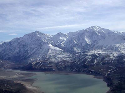
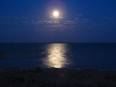
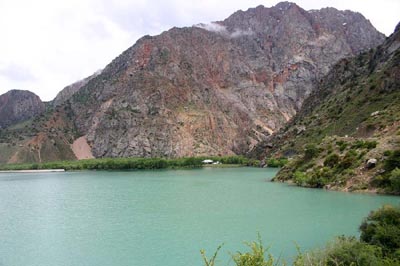
In a mountain part of a territory the lakes are also distributed irregularly. The Issik-Kul lake in the mountains of Northern Tian-Shan stands brightly against a common background The Issik-Kul is one of the greatest mountain lake all over the world. Many lakes have been formed in a result of the mountain crumbling. They have considerable dimensions. They are the Seraz and the Yashilkul placing in the mountains of the Pamirs. Ome of the most beautiful lake, the Iskanderkul, is in the mountains of the Gissaro-Alay. It was formed from obstructions and dams. The Karakul is the greatest alpine lake. It places in the Pamirs at a height of 3914m above sea level. The most amount of the lakes (about 80) is concentrated in the river valleys of the alpine zone. They are "trogi" distinguishing themselves for small slopes and a flat bottom, where favourable conditions are crested for forming of reservoirs. As a rule those lakes have insignificant dimensions. Amount of the lakes decreases when a height of a locality becomes lower. If about 50 lakes place at a height of 2000-3000 m above sea level then anly ten lakes number at a height of 1000-2000 m such insignificant amout of lakes in the low zone of the mountains is explained by strong erosion of the rivers That is obstacle of forming of lakes. Some mountain districts are rich in the lakes. They are: "sirty" of Central Tian-Shan (the Sonkel lake, the lake in the upper reaches of the Narin); the slopes of the southern ranges of the Tian-Shan (the lakes: Iskanderkul, Marguzor) and the Pamirs (the lakes Zorkul, Kara-Kul, Yashilkul and the others). The Aral Sea It is a reservoir without flowing out placing in the north-west of Central Asia. Accordingly diminisions of aquatory it is the second close reservoir in CIS and the fourth one in the world. The sea-shores of the Aral have various types. Along the western sea-shore the Ustiurt plateau stretches. It steeply lifts to the lake. Its precipice has a height of 250 m. The northern sea-shore is relatively high and is cut by big and small dismembered bays. A left sandy eastern sea-shore is strongly dismembered.
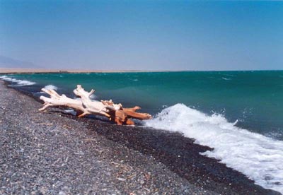
The southern sea-shore is also flat. It is occupied by the extensive delta of the Amu Darya. The basin source of a nourishment of the Aral Sea is a flow of the main rivers of Central Asia the Amu Darya and the Sir Darya. Water of the Aral is notable for big transparence especially in the central and the western parts. In the south-western and the north-eastern parts of the lake transparence of water is sharply lowered. The Amu Darya and the Sir Darya carry their turbid waters into the lake. Far from the sea-shores the colour of water seems blue there fore the Aral was named "the blue sea" in the olden times. The colour of is greenish at a littoral zone.
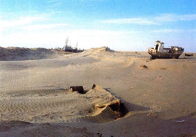
The Aral Sea is attributed to a row of the salt-lakes accordingly a degree of mineralization. Saltness of water is 10-11%, Heightened contents of sulphates in water differs water of the Aral from sea water and brings it to waters of the salt lakes. In summer the Aral Sea usually gets warm strongly. The water temperature even in open parts of the lake reaches 26-27oC in the upper layers. A twenty-four-hour's amplitude 1oC. When depth increases, the temperature of water quickly drops and the layers of water near the bottom have the temperature about 1oC in the deep parts of the lake. The numerous difference of the temperature of surface layer in different places takes place in the littoral zone. It depenends mainly on the different character of a sea-coast and winds. They move big masses of water are reasons of complex streams from the deep colder layers of water. It was noted that in summer the temperature of water in the littoral part of the lake is higher than in the open part, in autumn it takes place, other way round. Every year the Aral is frozen only in the northern, north-western and eastern littoral parts; the open part of the lake isn't usually covered by ice thanks to the winds. The water balance of the Aral is added up two parts: the receipt part and the expentse part. The first part is a tributary of surface waters (the Amu Darya and the Sir Darya) and precipitations dropping to the surface of the Sea. The second part is evaporation from the water surface of the Sea. Drain of a river water intended for the Aral Sea, its tributaries and basic oecological systems has led to the sea was dried up. At the beginning of 1960 the level of the Aral Sea is lowered, that proCess is contunueing at present. Deterioration of soil, growth of volumes of irretrievable useful ness of water and a row of dry years with little water have had a negative influence on its water and hydro-chemical regime. The Sea has lost more than 75% of its volume and a half of its aquatory. It has stepped back from the coast in some places more than 120 km, leaving the dry sea bottom on the territory over 33 ths.sq.km. The level of sea salt ness has become more than three times because of that the sea oecosystems and oranizms, which are able to live there, have been changed completely. The process of transformation the bottom of the sea into a desert takes place before one generation's eyes. On scales and intensity it has no analogy in the world practice. Its consequences have not been studied yet. The drying up of the Atal Sea has a negative influence on the change of the surroundings all over the "Priarale". The Balhash lake It is the lake without flow in the eastern part of Kazakhstan. It places in the extensive Balhash-Alakal hollow at a height of 340 m above level sea. The area is 17-22 ths.sq.km, the length is 605 km, the wide from 9 to 19 km in the eastern part to 74 km in the western one. A volume of water mass is 112 cub.km. The area of the basin is about 501 ths.sq.km. The most depth is 26 m. The great river Ily flows down into the western part of the Balhash. The small rivers-Caratau, Aksu, Lepsy and the others flow down into the eastern part. The northern shores of the lake, where the spurs of Kazakhstan "melkosopochnik" come up nearly to, are hight, rocky with tracks of ancient terraces. The southern shores are lowlying, sandy; they are covered by thick overgrowhes of reed. The sea-coast is rather winding. The shores are dismembered by the numerous coves and bays. Islands are not enough; the greatest ones are the Basaral and Tasaral. The climate in the district of the lake is like in a desert.
The average temperature of July is about 24oC, of January is about - 8oC. Average annual precipitation is 120 mm. Average moisture of air is 55-60%. Average annual aped of wind is about 4,5-4,8 m/sec. In the western part winds of the north directions predominate, in the eastern part winds of the north-eastern directions predominate. The winds call out strong choppiness on the lake. High summer temperature of air, low moisture, strong winds promote evaporation. In the cool years evaporations 950 mm, in the drought years it is 1200 mm. The Balhash is fruzed usually in the end of November, the ice in the lake is broken up in the middle of April. The highest levels are observed in a period of thawing of the mountain glaciers (June-July). An average annual amplitude of variation of the level is 3,2 m for last 20 years. The Balhash is half-fresh. Chemical properties of water depend on a peculiarity of a hydrography of a basin. The Sariesik peninsula goes out far into the lake and is divided the Balhash into two halves-the western one and the eastern one-united by the thin channel Uzinaral. Those halves differ from each other in hydrological attitude. Mineralization of water and maintenance of salts in the western and eastern parts and very different. It is explained that the great river Ily flows down into the western part of the lake. It brings about 73-80% of an annual amount of water (to 23,0 cub.m). In the western part of the Balhash the water is almost fresh (0,74 g/l), more turbid (transparence is to 1m), yellowish-grey; in the eastern part the water is saltish (5,21g/l), limpid (5,5m), a colour is from bluish to emerald-blue. The temperature of water on the surface is from 0oC in December to 28oC in July. In the depth the temperature is changed a little (difference of the temperature is no more than 3,3oC). The currents are wind, in the western part they are constant round. Fauna of the Balhash is rather rich. Bentos is presented by mollusks, larvas of water insects and lobsterous; plankton is also rather plentiful, especially in the western part. Twenty sorts of fish live in the lake. Six them are peculiar to the lake (Ily and Balhash marinka, Balhash pech, spotty and one colour gubach and golian), the rest sorts of fish are acclimatzed by man (carp,ship, eastern bream, aral barbell, Siberian elets, carp, tench, pike and the others). The main productive sorts of fish are carp, pike, balhash, perch, marinka, bream. Navigation is regular. The main landing-Stages are Burilbaital and Burlitabe. The Sarikamish Lake The Sarikamish region places to the south-west of the present delta of the Amu Darya. The whole territory of the region is occupied by the hollow of the ancient Sarikamish lake and adjoining from the east and the north-east the ancient delta of the Amu Darya. From the north and the west Sarikamish hollow is limited by the precipices of the Ustiurt. In the south it stretches to the draw-wells of Charishly where the row of reaches and lakes has adjoined the ancient Sarikamish lake. The Uzboy has taken its beginning from them. The relief of the region is tied to a considerable extent to its recent wide irrigation. Forming of the northern deltas of the Amu Darya was begun when the river has broken through to the north. It was evidently at the end of Hazarian or at the beginning of Hvalinian periods. River waters flowing down into Aral and Sarikamish hollows have created the great Aral-Sarikamish lake. Its level has reached about 58-60 m of an absolute height that is more than 10 m higher than present level of the Aral Sea. That maximum height of standing of water horizon in the lake confirm the most ancient Sarikamish lake deposits, banks of pebbles at a height of 2-3 m. In such level flow of lake waters into the Uzboy has cropped up. The river was formed. Gradual cutting of the sources into the absolute marks 50-52 m became condition to low the level of the lake. That lowering of the lake level has been accompanied by a division early indivisible lake into two lakes: the Aral and the Sarikamish. The level of the lake was being served by the indicated marks for a long time. Presence of an extensive terrace surface talks about it. That presence is expressed all over Sarikamish hollow and surrounds it by ring. In an interval of an absolute heights of 35-50 m some shore lines place. They are also shown by the plots of abradant terraces and banks of pebbles. The lowest plots of the bottom of the hollow are occupied by deposits of Cardium edule. Appearance of such deposits became possible here only depending on the numerous rise of salt ness of water in the lake. Well-formed shore banks of pebbles are also served from that farther stage. New rise of a lake level according to archaeological researches is attributed approximately to XIX-XX c. To that period a level of the lake reached 50-52 m again. Presence of well-preserved rests of irrigation systems and vodozabory placing on those marks in Sarikamish talks about it. Indicated level was preserved to the end of XVI th c. Last time waters of the Amu Darya penetrated independently into Sarikamish hollow in summer of 1878. It was a period of especially high rise of water in the river. In the north part of the hollow, on the lowest place, there were two lakes. In 1881 their depth reached 6 m and a level of water was lower than 38,7 m above sea level. Water in those lakes was still preserved in the beginning of XX th c. After 1913-1914 when a drought was, water from the lakes evaporated, on the bottoms of lake hollows salt marshes have stayed. The surface of the ancient Sarikamish delta of the Amu Darya is a monotonous plain. In the western and the south-western parts pf the plain there are "ostantzy". They rise at a height of 20-60 m above the surrounding locality. The ancient delta plain is cut through by not numerous hollows of the disappearing river-beds of the ancient Amu Darya. The most considerable river-beds from them are Dariarlik (Cunia Darya) in the north and Daudan in the south. At present a main Dariarlik circular canal is paved along an ancient river-bed of the Cunia Darya. That canal is a basin source of replenishment of waters in the Sarikamish lake. Its area is 2000 sq.km and the most depth is about 40 m. Issik-Kul The Issik-kul is a lake without flow. It is of the greatest mountain lakes of the world. It places at the northern Tian-Shan in the north-eastern part of Kirghizstan. It places at a height of 1608 m above sea level in the intermountain Issik-kul hollow between the Kungey-Alatau Range in the north and the Terskey-Alatau Range in the south. Its area is 6236 sq.km, a length is 178 km, the most width is 60 km, a depth is about 668 m, an average depth is 278 m, a volume of water is 1738 cub.km. Higher than 50 rivers fall into the Issik-kul. A total annual flow of those rivers exceeds 3 cub.km. The greatest rivers the Djergalan and the Tiup fall into the Issik-kul from the east. The Chu river falling along the western out-lying districts of the hollow some km from the Issik-kul has no connection with the lake now. Flow from the Issik-kul to the Chu was carried out when there was much water in the lake and the level of the lake was higher than present over 10-13 m. Such abundance of water last time was in 17-18 th.cc A nourishment of the river is complex, more snow; the rivers are abounding in water in the end of spring and in summer. The area of a basin of the Issik-kul is about 21,9 ths. Sq.km. Climate fluctuations have become a cause of the changes of the water level. The lake terraces of a height 8-10m and underwater ruins of settlements on the depth to 8m. During two last centuries the level of the Issik-Kul was lowering. From 1886 it dropped on 4 m (according to other facts on 7 m); during the centures against a background there are small fluctuations. Forming of high terraces (height is 35-40m) is connected with neotectonic motions. The shores of the Issik-Kul are dismembered weakly, only in the east and in the south-east there are deep bays (Tiupskiy, Djergalanskiy Pokrovskia Buhta). The length of the shore line is 597 km, more than a half of them is sandy shores; there are also the shores covered with silt and pebbles. The climate of the lake hollow is warm, dry and moderate. The temperature at a sea-coast in July is 16-17oC; in January is minus 2-3oC in the west; from minus 4 to minus 7oC in the east. An average precipitation above the Issik-Kul is about 250 mm, in the west-about 110 mm, in the east-470 mm. Evaporation from the Issik-Kul surface is about 700 mm. In the west and in the east there are strong winds (to 30-40m/sec) calling sudden storms. A height of windy waves is to 3-4 m. An annual amplitude of fluctuations of a level is 10-50 cm. The highest levels are in August and September, the lowest ones are in February and March. The temperature of water on a surface in January is 2-3oC, in July and August it is 19-20oC; in a depth higher than 100 m it is 3,5-4oC the whole year round. An ice is formed only in bays for cold winters. Water is blue (transparence is higher than 12 m), saltish (5,8%), useless to drink and to irrigate. In bays to a depth of 30 m there is almost solid cover of "harovie" water-plants and "rdest". A bottom is formed mainly with clay and silt. In the Issik-Kul there are about 20 sorts of fish. Fishery is a chebak, a goliy osman, a carp, amarinka. Every year water-fowls (pochards, wild ducks, lisuhy, swans) spend the winter on the bays and in the west of the Issik-Kul. In 1958 Issik-Kul reservation was organized. In the Issik-Kul a cargo and passanger's navigation is regular. The basin harbours (ports) are Balikchy (Ribache) and Pristan Prjevalsck. The grave of the Russian traveler N.M.Prjevalsky is near by the Pristan. The most of the settlements (populated points) places at the north seaside and at the eastern part of the hollow. The basin employment of the population is a husbandry (an agriculture, a cattle0breeding, a gardening) and also a fishery. At a distance of 7 km from the Issik-Kul there is the town Prjevalsck. On the northern shore of the Issik-Kul there is a climatic health resort Cholpon-Ata, on the southern shore there is Tamga. All over the sea-coast there are numerous rest homes, childrens' camps, tourists' bases. The Carakul Farther to the south of Markansu valley the Carakul lake lies. It is the greatest lake in the Pamirs and the third one in Central Asia according to its dimension. Its area of water surface is 380 sq.km, length is 33 km, the most width is 23 km, a maximum depth in the west part is to 236 m; in the eastern part-to 22,5 m. By its dimension and a height above sea level of 3914 m the Carakul lake is smaller than the lake-giants of Southern Tibet (Thibet). It places on the bottom of the great hollow. There is no flow from it there fore water in the lake is bitterly-salt. The lake is nourished with the rivulets and numerous temporary water streams flowing down from the surrounding mountains. The most considerable river the Muskol falls into it from the south; from the north-the Carajilga river. Transparence of water is comparatively not high (to 9 m)because the rivers, nourishing it, carry much weighed material. Water is dark-blue. From November to May the lake is covered with the ice. The lake was not always without a flow. About 100 ths. years ago it occupied almost the whole hollow and had a flow to the valley of the Cokuibel river. White stripes of the ancient lines of the breakers tell eloquently about former level of the lake. They are clearly marked on the slopes of the ranges surrounding a reservoir. Those ranges are higher than 100 m of a present level of the lake. Not numerous fishes-loaches tell about a former connection with the basin of the Cokuibel. They are cooped up in the mouths of small rivers falling into the lake where water is more or less fresh. They belong to the same sort which is found in the Cokuibel. But they have changed a little after they have lost a connection with the river. Carakul hollow has a tectonic origin. It appeared at the time of mighty tectonic movements enveloped the Pamirs in the beginning of the quaternary period. The hollow was filled up with a water step by step. Then great lake is formed. Now it is divided into two unequal parts by the island-range. It is stretched from the north shore to the south one and is separated from the shores by two thin sounds. Comparatively not long ago, still in the end of the past century the north part of an island was connected with the shore by then isthmus. Now the isthmus disappeared. It is connected with another interesting peculiarity of the Carakul-with its growing. The fact is that the shores of the lake lie on the ice at a considerable distance. The ice lies also on the bottom of the lake. Debates of its origin are taking place till now. Some scientists suppose that it is rests of ancient glaciers which have lowered directly to the lake. The other scientists consider that it is the rest of a glacial shield occupied the hollow also in a glacial period. The third scientists consider that an ice in the shores and an ice on the bottom are present formations. The shores of the lake lie on the ice. It melts step by step; as a result down falls, sounds and lakelets are formed. Small islands are separated from the sea-shores and the lake step by step is increased in its dimensions. Besides this there is another cause. It has a tectonic present motions of the bottom of the lake. The Jashilkul The lake is one of the most beautiful lakes of the Pamirs. It is formed as a result of falling dammed a valley of the Alichur river. The lake places at an absolute height of 3734 m, its area of its surface is 36 sq,km, length is about 22 km, the most width is 4,5 km, a maximum depth is 52 m. The southern and northern shores are mountainous. Here and there rocks are precipitous and steeply turn to the lake. A high rocky mountain-ridge formed mainly of granite stretches along the southern shore of the Jashilkul. That mountain-ridge is a spur of the Sothern-Alichur Range and has a height of almost 6000m above sea level. The northern shore of the lake forms precipitous spurs from the north-Alichur Range (the Bazardara Range). Its main crest rises to 5500m. The Jashilkul is mainly nourished by waters of the Alichur and also by the rivers flowing down from the south-Alichur Range, especially from the Bazardara Range. The biggest rivers of them are Bolshoy and Maliy Mardjanay. The river Gunt, the right tributary of the Piandj, flows from the lake. The most shallow part of the Jashilkul is the eastern one near-by the month of the Alichur. The river constantly carries out sand, silt and other sedimentary rocks into the lake and falls them out. Here the lake constantly grows shallow. The Jashilkul is connected with the lake Bulunkul by a channel. In it there are luxuriant overgrowths of water-plants and a rich plankton which is a splendid forage for fishes. Here there are few sorts of fish. But an amount of fish is big. There is only a marinka and an osman. In the lake there are many birds. But here there are no islands and no places where ducks, geese and seagulls could make their nests. The Sarez lake It is the youngest lake of all lakes of the Pamirs. It places at a height of 3229 m above sea level; its area of a surface is 86 km2; the most depth is 505 m; stock of water is 17 km. It appeared in 1911 on the place of kishlaks Sarez and Usoy as a result of falling of a giant mountain. That catastrophe is called "Usol obstruction". A wall of a height of 1 km and a width more than 5 km blocked the way of the river abounding in water. A stream of the Murgab was dammed. In October of 1913 a length of the lake was 28 km, a depth was 280 m. At present this lake by its depth is the second lake in the mountain region of Central Asia after the Issik-kul. The Zorkul The lake places in the southern part of the Pamirs at an absolute height of 4125 m. An area of its mirror is 39 sq.km. Its shape is a stretched ellipsis with a big axis (20 km) and a small axis (about 4 km). The lake is moraine origin. From the east and the west it is limited by the belt of moraines of a width to 4 km. In the past the lake had a higher level. The terraces placing at a height of 6m are told about it. A strong lowering of it level took place in the end of XIX c as a result of reinforcement of action of erosion of the Pamir river, flowing from the lake. The Iskanderkul (The lake of Alexander) It is the biggest lake of the Gissaro-Alay placing on the northern slope of the Gissar Range in Kuhistan. The lake is at a height of 2195 m above sea level; its area of its mirror is 3,4 sq.km, a length is 3,2 km, the most width is 2,9 km, a maximum depth is 72 m. A reservoir has been formed in an ancient glacial valley as a result of accumulation of moraine and a mountain falling. It has a shape of an irregular triangle. The shores of the lake are mainly steep, here and there, precipitous. Four terraces (17,35,90 and 117m above sea level) tell about its higher level in past. Four rivers (Saritag, Hozormech, Serima and a rivulet Peshtserniy) fall into the lake. And only one river, the Iskander Darya, flows out of it. An average annual expense near way out from the lake is 19,3 cub.m/sec. Lower the source the Iskander Darya forms a beautiful waterfall of 30 metres. The lake is almost lifeless. There is no fish except a small loach in it.
The Sonkel It is one of the greatest lakes of the Internal Tian-Shan. The lake lies in a wide hollow at a height of 3016 m above sea level. An area of a water mirror is 278 sq.km. A length is 30 km. The most width is 17 km. A maximum depth is 22 m. Ancient terraces on its shores tell that a level of the lake in the past was over than 100-150 m of the present level. The last lowering of a level on 2m took place in the end of XIX - at the beginning of XX c. Crests of the mountains surrounding it rise over it only on 600-900m. The lake is flowing therefore water is liquid and fresh in it. About ten small mountain rivulets flow down into it. But flowing out from the lake takes place through the only river, the Cokdjerty. It is a right tributary of the Narin. The shores of the lake partly become bogged up, are partly covered by reeds. The climate of the lake hollow is severe. From September the lake is still covered by ice which is preserved until the middle of June. Cold strong winds are often frequent. Summer lasts no more than a month and a half. The Chatirkel It places in the south of the Internal Tian-Shan at a height of 3530 m above sea level, an area of its mirror is 175 sq. km, a length is 23 km, the most width is 10 km. The lake is shallow. The most depth reaching 4 m there is in its eastern part. The lake is fresh. Waters in shallow bays are saltish. It is nourished by some tens of constant and temporary rivulets, flowing from the Atbashy Range. The last one places mainly to the north of the lake. The lake has no superficial ottock. The Sarichelek It places at a height of 1925 m above sea level in the eastern part of the Chatkal Range of Western Tian-Shan among the forests of Caricheleck reservation. An area of the lake is about 5 km2, a length is 7,5 km, the most width is 1,4 km, a maximum depth is 234 m. The lake appeared because of obstruction. It is flowing. It is nourished by waters of the Sarichelek and small rivulets and also by melted snow. The lake has liquid water. The water is blue with greenish nuances. The lake is surrounded by rocky mountains overgrown by fir-trees and spruce-trees.
|