RiversThe Amu Darya basinThe Amu Darya The Amu Darya.(in Latin "Oksus," in Arabian "Djeihun"). It is the most water-bearing river in Central Asia. Its length is 1415 km, from the source of the Pianj river is 2540 km. The basin of the Amu Darya is on the territories of Afghanistan, Tajikistan, Uzbekistan and Turkmenistan. The basin of the Amu Darya is the greatest river basin of Central Asia according to water collection. It occupies the area of about 465000 sq.km.The mountain part concluding the basin of the Zeravshan and the Cashka Darya occupies 255100 sq. km. from them.
Those rivers are attributed to the Amu Darya basin according to their hydrographical signs but they may be considered like the independent rivers because their waters do not reach the Amu Darya. The borders of the basin reveal themselves clearly only in the limits of the mountain region: in the south they go along the Hindu-Kush, in the east-along the Sarikol Range and in the north-along the Alay, Turkestan and Nuratau Ranges. A big area occupied by the glaciers and snejniky defines a character of nourishment of the greatest rivers of the basin. The most of them are attributed to the rivers of the glacier and snow nourishment (the Amu Darya, the Piandj, the Vahsh, the Zeravshan and some others). Only the rivers, forming flow in the western part of the basin, where the ranges distinquish themselves by the less heights, are attributed to the rivers of the snow and glacier and partly snow nourishment (the Kafirnigan, the Kizilsu, the Surhan Darya, the Cashka Darya).
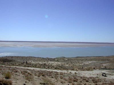
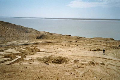
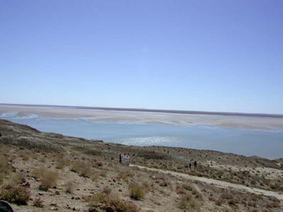
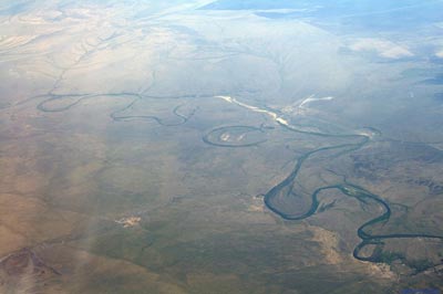
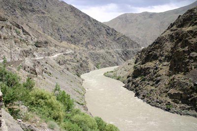
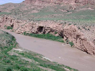
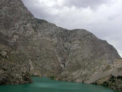
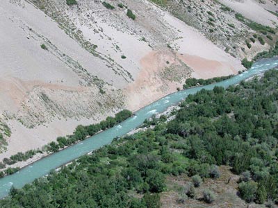
It is considered that the source of the Amu Darya is the Vahdjir river taking its beginning from the Vrevskiy glacier on the north slope of the Hindu-Kush at a height of about 4900 m above sea level. Below the stream of the river it is called the Vahan Darya but afther the connection with the river Pamirs-the Piandj; the Amu Darya receives its own name after the confluence the Piandj and the Vahsh. For the space of the first 180 kms its tributaries are the Kunduz, the Cafirnigan, the Surhan Darya, the Sherabad and then for the space of more than 1200 kms it has no tributaries before falling into the Aral Sea. On this plot about 40% of its fall are used for irrigation avaporation and infiltration. The typical peculiarity of the hollow of the Amu Darya is the presense of some broadenings like the lakes. They are on the plot from the confluence the Piandj and the Vahsh to the town Kerky. The river-bed of the river is divided into some channels and forms the numerous islands here. The flood-lands of the river are covered by the "tugay", the thick overgrowthes of the reed and abound in the numerous lakes and bogs. From the town Kerky to the gorge Eldjik the width of the Amu Darya hollow is fluctuated from 4 to 25 kms. Its gentle slopes imporceptibly are melted into the surrounding locality. The character of the hollow is changed between the gorges Eldjik and Tiuiamuiun. Here the river flows down in the redical rocks. That is a thickness of sand and crumbly sandstone of the terriary period. The slopes of the hollow are steep and precititous; a height is 10-20 m. On this plot sands of the Kizilkums and Caracums come to the hollow of the river directly. Lower the gorge Tiuiamuiun the valley, of the Amu Darya become roider than some tens of kilometers. It becomes thinner only about the gorges Djumir-Tau and Tahia-Tash. On this plot of the hollow the most quantity of the cultural lands are concentrated. They are irrigated by the greatest irrigation systems. The complex system of dams is stretched here along the low bank of the river, protecting agricultural lands from submergence during high water and winter accumulation of ice. In the district of the town Nukus a dry branch Daryalik (Kunia Darya) moves away from the Amu Darya in the left. In the past the part of the Amu Darya waters flowed down along it to the Saricamish hollow and from it the Amu Darya flowed down to the Caspian Sea along the ancient river-beg. In the end of XIX c (1878) the waters of the Amu Darya broke through to the Saricamish hollow during flood-time. It is detemined that flow from the Saricamish hollow was along the Uzboy still in the Middle Ages. The flow of water was not lengthy but it was interruped. Because of it there were no lengthy settlements of the people on the banks of the Uzboy in that period. The flow of water along the Uzboy was almost to the end of the XVI c. The Amu Darya delta is began lower the town Nukus by the town Tahia-Tash. The delta is a weekly sloping plain crossed by the numerous channels.
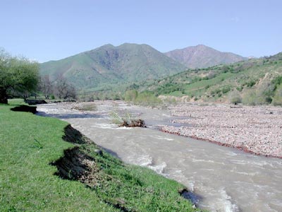
Crumbly rocks of the desert banks do not bear an onset of a rapid of the Amu Darya. The river always changes its river-bed, eroding the right bank most of all and constantly displacing to the east. This natural phenomenou explanes unusual turbidity of the Amu Darya water. It contains on the average 3,6 km of alluviums in a cubi metre, that is more than in the Nile. During high-flood the Amu Darya becomes especially furious and destroying. There are two high-floods in this river. It has a mixed nourishment: snowy and glacial and rainy. The first high-flood takes place in spring, in April and in May, when snow melts on the low mountains and it rains heavily. The second one takes place in summer, in June and July, when the southern sun melts snow and glaciers of the alpine mountains. One high-flood often buses into another one and thus big water flows in the Amu-Darya 4-5 months in succession.
In the low reaches the river freezes every year. In the district of the town Nukus the river is ice-bound for almost 4 months. The transport meaning of the Amu-Darya is not big because one basin of the Aral Sea is reserved and is very unfavourable for navigation. In the impetuous waters of the Amu Darya there are next (types) kinds of fish: a big and small lonatonos, a carp, a pike perch, a barbell, a sheat-fish. Pheasants, kvakvy, grey and red heron and numerous inse tivorous birds make their nests in the riverside overgrowths of the rivers. In the "tugaiah" there are wild-boars, foxes, jackels, wolves and cane cats. High moisture of the air and soils, softening action of the Amu Darya and its numerous channels which nourish the flood-lands during high-floods promote violent growth of the tree and the bush vegetation: sizolistnaia and raznolistnaia turanga, loh, riverside willows, lomonos the eastern, djengul. The grasses: kendir, solodka, veinik, eriantus, tzistanhe, povelika of Lemanna predominate. The Piandj The Piandj is the upper reaches of the Amu Darya. Its length is 921 km; its area of the basin is 114 ths.sq.km. In its upper stream before the village Ishkashim the valley of the river has a width from one to five km; here and there it is covered with "tugay", here and there it is covered with meadows. The river-bed is wide, is often broken into the branches; its current is queit. Below the village Ishkashim the Piandj turns steeply to the north; the valley of the river grows narrow. Here and there it becomes darks gorges like canjons width of which of some tens of metres. In those places the river forms rapids and waterfalls. When it comes out of the mountains near the village Chubek the Piandj valley widens, a speed of the current drops. Broken into the branches the Piandj forms marshy island Urta-Tugay in its low current. The length of the island is 50 km and the width is 15 km. It is covered with reeds and rushy. The name "Piandj" means "five rivers". Five rivers: the Vahan Darya, the Pamirs, the Bartanga, the Gunta and the Banch nourish mainly the Piandj. The two first rivers, as it was mentioned, pour together and form the Piandj; the theree rest of the rivers are its right tributaries. All they are attributed to the rivers of the glacial and snow nourishment because their sources take their beginning from the mighty glaciers. For the most of their extent those rivers flow in deep gorges. Big drops, full of rapids river-beds and stormy rush currents are typical for those rivers. Only the Cokchy may be mentioned from the five left tributaries Bartang Bartang is the greatest tributary of the Piandj. Its length is 405 km, the are of its basin is 32700 sq.km. It fall out under the name of Aksy from the lake Chakmaktinkul placing on the territory of Afhganistan. After pouring together with the river the south Akbaital (in the limits of the Pamirs upland) that river receives another name. That name is the Murgab. It preserves that name to the Sarez lake and then it receivesthe name of the Bartang. Bartang flows in a thin rocky gorge between the Rushan and the Yazgulem Ranges to the very mouth. Gunt The Gunt is the other great tributary of the Piandj. Its length is 246 km; the area of its basin is 14840 sq.km. Its source (the river Alichur) takes its beginning on the Pamirs upland, where the river flows on a marshy plain having signs of an ancient earth being covered by the ice. The river is called Gunt after it comes out from the lake Yashilkul. The Gunt flows with stormy and rash stream on the plot from the lake to the mouth, forming the numerous rapids on its way the Piandj the Gunt takes the great tributary, the river Shahdar, from the left side. Vanch The Vanch Its length 92 km, the area of basin is 1990 sq.km. It receives its basin nourishment from the great glaciers of the Akademia Nauk Range and also from the numerous tributaries flowing down from the Vanch and Darvazar Ranges. They stretch along its valley. The river is abounding in water. It is characterized with big fall, quick current. In its river-bed there are rapids and waterfalls. The Zeravshan The Zeravshan (in the upper reaches is Matcha) is a river in Uzbekistan and Tajikistan. Its length is 877 km, the area of the basin is 17.7 ths.sq.km. The average expense of water is 162 m3/ sec. It takes its beginning from the Zeravshan glacier in the mountain knot between the Turkestan and Zeravshan Ranges. The river is nourished on a whole by glaciers and snow. The most flow in the river is in summer (in July, in August) there fore. But in a cold period the Zeravshan carries little water. In summer water in the river is turbid, grey-steel-blue; in winter it is clear and limpid. In the limits of Tajikistan the Zeravshan takes three big tributaries-the Fan Darya, the Kshtut Darya and Magian Darya, flowing down from the Gussar Range, and more than 100 are small. The Zeravshan flows in a deep gorge, now in a specious one with a row wide terraces, now in a very thin one. In the valley there are often landslides and landslips and as a result temporary dammed lakes are formed. The great landslide-landslip took place in the 24 of April in 1964 (the seventh during 900 years) near the district center Lini. Here about 50 m cubic metres of stones came down from the Darpvorz to the valley and blocked the way of the river. A lake was formed. Its level grew quickly. Threat of catastrophic break of the forming dam was appeared. Only urgently taken measures averted inevitable calamity. Lower t.Pendjikent Zeravshan comes out from the mountains. Its river-bed is broken into branches forming islands are rich of natural and especially cultural vegetation. Near by Samarkand the Zeravshan river-bed is divided into two branches-the Ak Darya and Cara Darya. By the settlement of Hatirchy the river is squeezed by two going out of radical rocks and then flows in a river-bed. The lower reaches of the Zeravshan are nourished by water of the Amu Darya thanks to the Amu-Bukhara canal. Earlier the Zeravshan fell into the Amu Darya; now it is losing its waters in the Kizilkums desert forming two deltas: Carakul and Bukhara. On the river there are Cattakurgan and Cuiumazar reservoirs.
The Vahsh The Vahsh is a river in Tajikistan. It is in the right side of the Amu-Darya. Its length is 524 km the area of its basin is 39,1 ths.sq.km. The average expense by confluence with the Piandj is 650 m3/sec. A nourishment is glacial-snow, less rainy. From May to September there is flood. Waters of the Vahsh are distinguished with big turbidity (4,16 kg/m3). Confluence of the rivers Kizilsu and Muksu is formed. Kizilsu takes its beginning from the Zaalay Range and flows along the Alay valley, where it takes some rivulets they flow down from the glaciers and snejniky of the Alay and Zaalay Ranges. Going the Alay valley the river flows in a deep thin gorge. After it comes out of the gorge it pours together with the river Muksu. The Muksu is nourished by the greatest glaciers of the northern slope of the Peter the Great Range and in particular by the glacier named after Fedchenko. After the confluence of two rivers the Kizilsu and Muksu the river has another name, the Surhob. Lower the confluence with the only considerable tributary from the left side, the Obihinhou, the river is named Vahsh. The tributary Obihinhou is nourished by the great glaciers Garmo, Sitark, Arnavad and the others. Almost for all space the Vahsh flows in the thin valley. Here and there it is converted into an impassable gorge having width 8-10 m. Here and there the gorge is widened to 1,5 km. The Vahsh flows only last 150 km on the wide (to 25 km) valley. Low places of the valley are marshy and occupied by constant and drying up lake lets. On the plot of low current the river-bed of the Vahsh is broken into the numerous branches. A canal moves away from the Vahsh in the district of the town Kurgan-Tiube. The canal irrigates the left-bank plains and the plateau Djulikul. The river in the low reaches is navigable. The Caphirnigan The Caphirnigan is a river in Tajikistan. Its length is 387 km, the area of the basin is 11.6 ths.sq.km. The average expense is 169 m3/sec. It is formed by the confluence of two rivers: the Sardan-Miena and the Sorbo. It takes its beginning on the southern slope of the Gissar Range. In the upper reaches it flows on a granitic gorge; in the middle reaches it crosses the wide Gissar valley where here and there the river-bed of the river is widen to 200 m, forming some islands. Lower a confluence of the last tributary comed into the gorge again. Here and there it is widen to 2 km. In the lower reaches of the river it is broken into some branches, forming some islands of pebbles. Here and there they are covered by thick vegetation. Two high-floods are observed on the river. The first high-flood takes place in April when snow melts and the tributaries with low "vodosbor" (the rivers Iliak, Liugob,Simiganich) are disninguished with the most expenses. The second high-flood takes place in June-July from the intensive melting of alpine snow and glaciers in the basins of its tributaries: the Sardan-Muena and Varzob. The Surhan Darya The Surhan Darya - is a river in Uzbekistan, is the right tributary of the Amu Darya. It is formed by a confluence of two rivers: the Tupalang Darya and the Caratag,flowing down from the southern slope of the Gissar Range. A length is 175 km (from a source of the river Caratag is 287 km), an area of the basin is 13500 sq.km. A flood-time is from June to August. An average expense of water in 6 km of the moth (a range Manguzar) is 65,8 cub.m/sec. On the Surhan Darya there is Southern and Surhanian reservoir. It is for irrigation.
The Sherabad The Sherabad Darya is a river of the Surhadarya region in Uzbekistan. It is the right tributary of the Amu Darya. In a source it is the Irgaily; in the upper reaches it is the Machai Darya; in the lower reaches it is the Carasu. A length is 177 km, an area of the basin is 2950 sq.km(before coming out of the mountains). It takes its beginning from the Baisuntau Range. A nourishment is snow-rainy. An average expense near the town Sherabad is 7,5 cub.m/sec; lower of Sherabad river a net of canals goes off and water is taken out for irrigation. An irrigation far of the Sherabad is nourished by water from the Surhan Darya.
The Cashka Darya The Cashka Darya is a river in Uzbekistan. Its length is 378 km, the area of its basin is 8,8 ths.sq.km. In the souce it is the Shingasoy, in the lower reaches it is the Maymanak Darya. It takes its beginning in the western spurs of the Zeravshan and the Gissar Ranges. From the settlement of Duab it flows on the wide valley takes from the left-hand some tributaries, the most of which carry more water than the Cashka Darya does. The basic tributaries are the Aksu, Tanhaz Darya, Jakkabag Darya (Kizil Darya) and Guzar Darya Nourishment is snow-rainy. High water is in spring; in summer there is little water in the river. The average expense of water from the mountains is 24,9 cub.m/sec (266 km from the mouth). Waters of the Cashka Darya is widely used for irrigation. Behind the Cashka Darya its river-bed is step by step lost. Cashka Darya is nourished by waters of the Zeravshan with the help of the Eskianhor canal. On the Cashka Darya there is Chimkurgan reservoir and on the Guzar Darya there is Pachkamar reservoir. The Sir Darya basinThe Sir Darya The Sir Darya is the longest river in Central Asia but it is on the second place after the Amu Darya according to quantity of water. Its length is 2212km, from the sources of the Narin is 3019 km. The Sir Darya basin is on the territory of the Republiks: Kirghizstan, Tajikistan, Uzbekistan, Kazakhstan. The basin of the Sir Darya occupies an area of 462000 sq. km from which the mountain part of the basin is 223000 sq.km. In the north natural boundaries of the basin are the Terskey-Alatau, Kirghiz, Talass Alatau and Karatau Ranges; in the south and in the east the basin is limited by the Akshiyrak, Borkoldoy, Atbashy, Alay, Turkestan and Nuratau Ranges. The highest points of the basin are on the Alay and Turkestan Ranges. Some peaks rise to 6000 m above sea level.
In spite of a big height of many ranges alpine snow and ice fields in the Sir Darya basin are developed considerably weaker than in the Amu Darya basin taking place southwardly. It may be explained that the average high of the Sir Darya "vodosbor" is less than in the Amu Darya; that the highest ranges of the basin are in very unfavourable conditions of moistening. It is especially right concerning the ranges where the sources of the Narin take their beginning. They take place in depth of the mountain country and receive more than half of precipitation in summer. Character of nourishment and regime of the rivers of the basin are in full accordance with development of the process of "oledeneniya" and alpine snow. The rivers of the Sir Darya basin : the Big and Small Narin, the upper current of the Narin, the left tributaries of the Sir Darya (Aksu, Icphara) and some other rivers, flowing down from the Alay and Turkestan Ranges, have ice and snow nourishment. In July-August they have maximum lifting of a high-flood wave. The greatest tributaries of the Sir Darya- the low current of the Narin, Cara Darya and Chirchik-are the rivers of an ice and snow nourishment with maximum flow in May-June. The Sir Darya is formed by confluence of the Narin and the Cara Darya in the eastern part of Ferghana valley. It falls into the Aral Sea. The territory of the basin is stretched from the south-east to the north-west. The south-eastern part is a mountain country. The north-western part has a plain character. A watershed is vague expressed here. The average water resources of the Sir Darya basin are 36,- cub.km. a year. Water cultural system of the basin is a complicated complex of engineer constructions including reservoirs, nets of irrigative canals and collectors. Complete volume of the great reservoirs is more than 34 cub.km, that is the annual volume of flow may gathered in the reservoirs. In the middle and low parts of the basin there are salt break lakes. They are formed by the next method: collector-drain water is taken aside to the desert lowings and hollows. The greatest lake is the Aidarkul lakes. A volume is 11, 6 cub.km. The Sir Darya basin is a complex interlacement of natural and artificial water streams. They are rivers, canals and collectors. An extent of canals and collectors considerably rise an extent of river net. The most tributaries of the Sir Darya flow down from the mountain outlying districts of Ferghana valley. The right tributaries are Kasansay, Gavasay and Chaadaksay. The left tributaries are Icphayramsay, Shahimardan, Soh, Icphara and Hodjabakirgan. No one of them carries its water to the Sir Darya because they are used for irrigation. About 700 canals are built from those rivers which flow down to the valley. In the limits of the valley 50 canals are built. The greatest canals are taken form the Narin. They are: Bbig Ferghana canal (with water also from the Cara Darya), Big Andijan canal and North Ferghana canal; Andijancay, Shaarihansay and Savay canals are led from the Cara Darya; canal named after Ahynbabaev is led from the Sir Darya. Water comes to the mountain rivers and the Sir Darya from more than 100 collectors and breaks (faults). Among them there are 43 into the Cara Darya ann 45 into the Sir Darya. The greatest collectors are SariSu, Caragugon, North-Vagdad. Before coming out of the Ferghana valley the Sir Darya cuts the Ferhad mountains, forming Begovat rapids. Then it turns to the north-west and flows on an extensive here and there marshy flood-lands. Its width is 10-15 km. The Sir Darya crosses Tashkent and Hungry steppe depression. The Ahangaran, the Chirchik and the Keles fall into the middle current of the Sir Darya. That is from going out of Ferghana valley to the Chardarin reservoir. The south Hungry steppe canal is begun on the Sir Darya from Farhad hugro-electric power station. In its lower current the Sir Darya crosses the eastern outlying districts of the Kizilkums. The river-bed of the river is higher than the surrunding country. The locality is winding and unstable; there are often floods. The last tributary is the Aris (right). Small rivers flowing down from the Caratau Range do not reach the Sir Darya. In its mouth the Sir Darya forms the delta with the numerous branches and channels, lakes and bogs. Spring high-flood in the Sir Darya takes place in March-April. It is formed because of melting snow on the plain part of the basin and the foot hills. In May the second, main, high-flood is begun. It reaches its maximum in July. Minimum of flow is observed in December-January separate momentary high-floods are observed on a wave of the main high-flood usually. They have place by reason of rains and unleven melting of glaciers and alpine snow in different parts of the basin of the river. The flow is regulated by the reservoirs. The greatest reservoirs are the Cairakkum and Chardara in the Sir Darya (total useful volume is more than 7 cub.km) and also the Toktogul (14 km 3) in the Narin, the Andijan (1,6 km3) in the Cara Darya. The Sir Darya is navigable from the mouth to Bekabad on the separate plots. The Narin The Narin is a right component of the Sir Darya the territory of Kirghizstan and Uzbekistan. Its length is 807km, the area of the basin is 59,1 ths.sq.km. The average expense of water is 429 cub.m/sec. The Narin basin is stretched in parallels to latitude. From the north the basin is limited by the Terskey-Alatau, Kirghiz and Talass Ranges, in the south-the Atbashy and Ferghana Ranges.
The Narin is formed by a confluence of the Big and Small Narin, taking their beginning in the Internal Tian-Shan. The river Cum-Tir is a main component of the Big Narin. It flow from the glacier named after Petrov (massif Akshiyrak), lowering to 3786 m above Sea level and being a mighty glacial stream of a length to 16,8 km. The Burhan river is a main component of the Small Narin. It is formed from the numerous rivulets flowing from the glaciers of the northern slope of the Djetimbel Range. An expense of water at the place of confluence of the Big and Small Narin is 90 cub.m/sec. After a confluence the character of Narin valley is often changed. Broadened plane plots of the river are changed by thin gorges like canyons. In them there are many rapids and currents are very stormy. The Narin takes lots of the tributaries. The main of them are the Atbashy, Alabuga from the left side; the Kekdjerty and Kekemeren tributaries are from the right side. The Narin with them cuts through the Ferghana Range. Coming out to Ferghana valley the Narin loses a character of a mountain river. It flows on its cone of accumulations. Having broken into the some branches the Narin forms the flood-lands of pebbles of a wide to 3,5 km. In the limits of Ferghana valley the Narin joins the Cara Darya and forms the Sir Darya. The Narin is attributed to the rivers of a snow-glacial nourishment in it upper current. A high summer flow is typical for such rivers. Lower on the current the annual distribution of flow is step by step changed because of lowering of a height of a "vodosbor" and change of conditions of nourishment. From the Narin the Big Ferghana Canal is begun. On the river there are Toktogul, Uchkurgan and Tash-Cumir hydro-electric power stations. The Cara Darya The Cara Darya is a left constant of the Sir Darya on the territories of Kirghizstan and Uzbekistan. Its length is 180 km, the area of the basin is 30,1 ths.sq.km. An average expense of water is 120 cub.m/sec. It is formed by a confluence of the Karakuldja and Tar rivers taking their beginnings on the slopes of the Ferghana and Alay Ranges. Firstly the Cara Darya flows on a wide valley in a strongly branched river-bed of pebbles. Before coming out to Ferghana valley the river breaks through Campirravatgorge, where it flows here and there on marshy flood-lands dividing into some branches. A nourishment is snow-glacial. The most expanses are in June, the least ones are in winter. The basin tributaries are the Kurshab from the left hand; the Jassy, Cugart and Caraunkiur from the right hand. On the Cara Darya there is Andijan reservoir. The Chirchik The Chirchik is a river in Uzbekistan. It is the right tributary of the Sir Darya. Its length is 155 km from the sources of the Chatkal its length is 328 km. The area of the basin is 14,9 ths.sq.km. An average expense of water in the source is 221 m3/sec. It is formed by a confluence the rivers Chatkal and Pskem in the Charvak reservoir, from where the Chirchik river flows out directly. After the Charvak reservoir the Chirchik takes only two considerably great tributaries: the Ugam and Akcakatasay. On the upper plot (about 30 km) the Chirchik flows in a canyon; lower the valley is widened is expressed weakly. When the Chirchik comes out to the plain, its waters are intensively taken for irrigation and for needs of hydro-energetics therefore the volume of water in the river is decreased. A nourishment is mixed but more snow. Above the Gazalkent dam Bozsuy canal goes out to the right from the Chirchik; above the Troitsk dam the Karasu canal goes out to the left; lower the Chirchik nourishes the other canals. In the Chirchik valley there are some towns: Gazalkent, Chirchik, Tashkent. Chatkal The Chatkal is the main component of the Chirchik. It takes its beginning on the south-western slopes the Talassk Alatau. Having taken its greatest tributary Chandalash from the left the Chatkal converts into the river abounding in water. In the high current it flows on the wide ancient glacial valley. Lower a confluence of the river Ters the valley of the river gets narrow and passes into a deep gorge, which is ended before flowing to the Charvak reservoir. Pskem The Pskem is the second component of the Chirchik. It is begun in glaciers of the Talassk Alatau and is form by a confluence the rivers Oigaing and Maidantal. In the upper reaches the river flows on the wide river-bed of pebbles which cut through to the ancient glosial valley. In that place where the river breaks through the Turpakbel spur, it flows in a thin canyon forming rapids and shoals.
The Ahangaran (Angren) Its length is 233 km, the area of the basin is 5,3 ths.sq.km. An average expense of water is 20,2 cub.m/sec. It is formed by the numerous rivulets flowing down from the southern slopes of the Chankal Range. In the upper and middle reaches the Ahangaran cut through Angren plateau by (with) a deep canyon. After coming out of it, the valley of the river is a wide gorge between continuation of the Chatkal Range in the north-west and the Kuramin Range in the south-east. In the lower current the Ahangaran breaks through to the Chirchik valley and flows in parallels the last one before flowing into the Sir Darya. The right tributaries of the Ahangaran flow down from the Chatkal Range in the upper and middle parts of its valley forming deep gorges. After coming to Ahangaran plateau they become plain rivers and are distinguished quiet current and meandering character. When they are brought nearer to the Angren fall of the tributaries is sharply increased and they are rushed down into it with beautiful waterfalls. Above the town Angren there is Ahangaran reservoir. The Soh The Soh is the river in Kirghiziya and Uzbekistan. Its length is 124 km, the area of the basin is 3510 km2. It takes its beginning on the north slopes of the Alay Range. It is finished by an extensive cone of a river alluvium. It is cut through by the irrigating canals. A nourishment is glacial-snow. High water takes place from June to September. An average expense of water is 42,1 cub.m/sec. It is near-by kishlak Sarikonda, 44 km of the mouth. Waters are used for irrigation and do not reach the Sir Darya. The other riversThe Ily The basin of the river is Kazakhstan and China. Its length is 1001 km, from a source it is 1439 km. The source is Tekes. The area of the basin is 140 ths.sq.km. A nourishment is glacial-snow. 700 glaciers of the Djungar Alatau and the Tian-Shan and 800 rivulets and small water streams nourish it. Its average expense of water is 464 cub.m/sec. An average annual expense of water is 329 cub.m/sec by flowing into the Balhash. An average turbidity is about 1kg/m3. It is frozen in December; the ice in the river is broken up in March; its high water is continued from April to August. It takes its beginning in Eastern Tian-Shan from two source: Tekes and Kunges. They join in Sintszian (China). It drops into the Balhash lake. The main tributaries are: Cash, Horgon (from the right side) and Charin, Chilik, Talgar, Kaskelen, Kurty (from the left side). In the upper current it is a mountain river. Lover the mouth of the great right tributary Cash a valley is widened and the Ily is broken into some branches. Up to the Canchagay mountain the river flows in a bottom of a wide hollow in low banks. Here and there those banks are marshy. Lower it comes into the deep canyon Capchagay when Capchagay HES is built. After falling of its last tributary-the Curty-the valley is sharply widened and the river flows among sands of the Sary-Ishikotrau and Taukum. At 340 km from the mouth of the Ily the dry river-bed Bakanas goes away of the Ily. Here it is begun an ancient delta of the Ily. One hundred lower there is a present delta (area is 9000 km2) with the numerous branches. They are rushy. The Ily and its tributaries are great irrigating significant. The Ily is rich in fish; in the delta there is hunting of "ondatra".From the town Culdja (Inin. China) the Ily is open to navigation for ships with little draught. In the limits of Kazakhstan there is regular navigation from the state boundary to the landing-stage Bakanas; lower-voyages of some cutters. Where two tributies of the Kaskelen-the Big and the Small Almaatinkas-come out of the mountains there is Alma-Ata. The capital of the Republic. The Chu The basin of the river is on the territory of Kirghizia and Kazakhstan. Its length is 1067 km; the area of the basin is 62,5 ths.sq.km. An average expense of water is about 70m3/sec. A nourishment is glacial-snow; a role of underground flow is essential. The most flow is in July-August; in the end of July and in the beginning of August it becomes dry; in December flow appears again. In the upper reaches the ice appears; from November to April there is the ice only here and there (about 10 twenty four hours on the average); in the lower reaches the ice from December to March. The rivers Kochkor and Djuvanarik flow together in the Tian-Shan. They take their beginning fro glaciers in the Terskey-Alatau and Kirghiz Ranges. Lower their flowing the Chu is broken to the Issik-Kul hollow where it flows near the Issik-Kul lake. In high water a part of flow is dropped to the lake on the branch Kutemaldy. The river comes out to Chu valley through Boam goge. The numerous tributaries, the main of them is the Chonkemin, flow down from the surronding mountains. In the lower reaches it crosses the desert Muiunkum and is lost in the hollow Ashtsikol, forming a group of lakelets. The main tributaries - Chonkemin, Irgaity, Kakpatasfrom the right hand; Alamedin, Aksu, Kuragaty-from the left hand. In the Chu there is Ortotokoy reservoir and three water-lifting dams. There are some numerous irrigating canals. 55% of flow are used for irrigation. There are two town Tokmak and Chu in the Chu river. In the past the river Sirasu joined the Chu and their waters reached the Sir Darya. And now their drying up months are divided by the distance of 120 km. The Sarisu takes its beginning in Kazakh "melkosopochnik". When there are much water the Sirasu reaches the salt lake Ashtsicol lying on the Turan plain at the distance of 1000 km from its sources. In a year when there is little water the river is stopped in a desert at a distance of 200 km nearer, but the lake Ashtsicol is converted into "sor" that is a salt-marsh. According to its regime the Sirasu is a typical plain river. It is mainly nourished by melted snow, therefore high water of the river is in spring. Only pools of river and among them small streams are stayed here and there by summer. The Talass The basin of the river is in Kirghiziya and Kazakhstan. Its length is 661 km, the area of the basin is 52,7 ths.sq.km. An average expense of water is 32 m/sec. The river is formed by a confluence of the rivers Karacol and Uchkosha nourished by the flow from the slopes of the Kirhiz and Talass-Alatau Ranges. Lower confluence of those rivers the Talass flows on a wide valley breaking into some numerous branches. Before the settlement "Kirovskoe" the Talass has the most developed net of some tributaries. Their waters are used for irrigation and often do not reach the Talass. From the west the river rouds the Kirghiz Range and comes into the open steppe. Here the river is taken for irrigation and partly is lost for evaporation and infiltration. The Talass is finished by the net of some lakes and bogs in the plain spaces of the desert Muiunkum. In the past the Talass was a tributary of the Chu. And now doest reach it The Murgab The basin of the river is in Turkmenistan and Afghanistan. Its length is 978 km, the area of the basin is 46,9 ths.sq.km, an average expense of water 52 cub.m/sec. It takes its beginning in Paropamiza mountains in Afghanistan. In the upper reaches it typical mountain river flowing in a thin valley which converts into gorge here and there. A considerable tributary Abykaisara falls into the Murgab. After that it comes into the limits of Turkmenistan. Here its length is about 350 km. The river flows in a brightly outlined valley with a wide of 7 km. The whole valley up to the delta is divided into two sections. The first one is ancient, formed mainly by sand which was exposed to considerable weathering. The second one is youger where clayey deposits are developed. In the lowest reaches the valley joins the landscape forming the specious dry delta. The Murgab is one of the most water-bearing rivers of Turkmenia. The left tributaries-Kashn and Kushka-have an essential influence on forming of a spring high-flood of the Murgab. Below those tributaries the river-bed of the Murgab is partitioned of by a row of dams and created reservoirs are regulated spring flow of the rivers. The dam Kayshyt - Bent divides almost all the rest of flow of the river among the canals. And the main river-bed of the river dries up and is lost in the Caracums. It is at a distance of about 100 km below the town Mary. The Tedjen The basin of the river is in Turkmenistan, Afghanistan and Iran. Its length is 11150 km, the area of the basin is 70,6 ths.sq.km. An average expense of water is 31 m3/sec. It is begun in a junction of the Paropomiz and the Hindu-Kush, before a confluence with the Kesh-Phrud that river is named Herurud. Before the town Herat the Tedjen is a mountain river. It flows in thin valley forming rapids and waterfalls. After Heart valley the river steeply turns to the north. It cuts through the Saphedkoh Range and comes into the limits of Turkmenistan when it flows about 300 km. The river valley, having a width of 2 km here and there, is limited by steep loess banks. Here and there the valley is covered with thick shrubbery overgrothes. In summer the Tedjen river-bed dries up below the settlement Pulihatum because water is taken for irrigation. In separate places water is preserved constantly because the land is soaked by waters after irrigation. Higher the settlement Serax the river takes some tributaries from which only one of them, the Keshe-Phrud, brings its waters to the main river. The Tedjen delta is a sandy-clayey plain dismembered by the numerous of the river-beds. A pert of the area of the delta is occupied by cultural vegetation. Here and there are marshy spaces with reeds and rushy spaces. The Atrek The only river of Turkmenistan belonging to the basin of the Caspian Sea. Its length is 669 km; the area of the basin is 27,3 ths.sq.km; an average expense of water is 13,2 cub.m/sec. Its sources and bigger part of its stream lie in Iran on the southern slopes of the Copentag. And only 140 km of its lower reaches are in the territory of Turkmenistan where it brings very small part of it flow. After the river comes out to the boundary of Turkmenistan the last and greatest tributary flows into it. It is the Sumbar. The Atrek is shallow even in comparison with the Tedjen. It is explained that the mountain ranges in its basin don't exceed 2000-3000 m above sea level. Besides their places are unfavourable relatively aerial masses carring moisture. The river-bed of the Atrek is in not strong rocks therefore its water is very turbid. It is most turbid river among the rivers of Central Asia and it is the most turbid of the rivers in the world. Every cubic metre of its water contains at an average 25 kg of weighed (suspended) fractions. It exceeds turbidity of the Amu Darya 6 times as much.
|