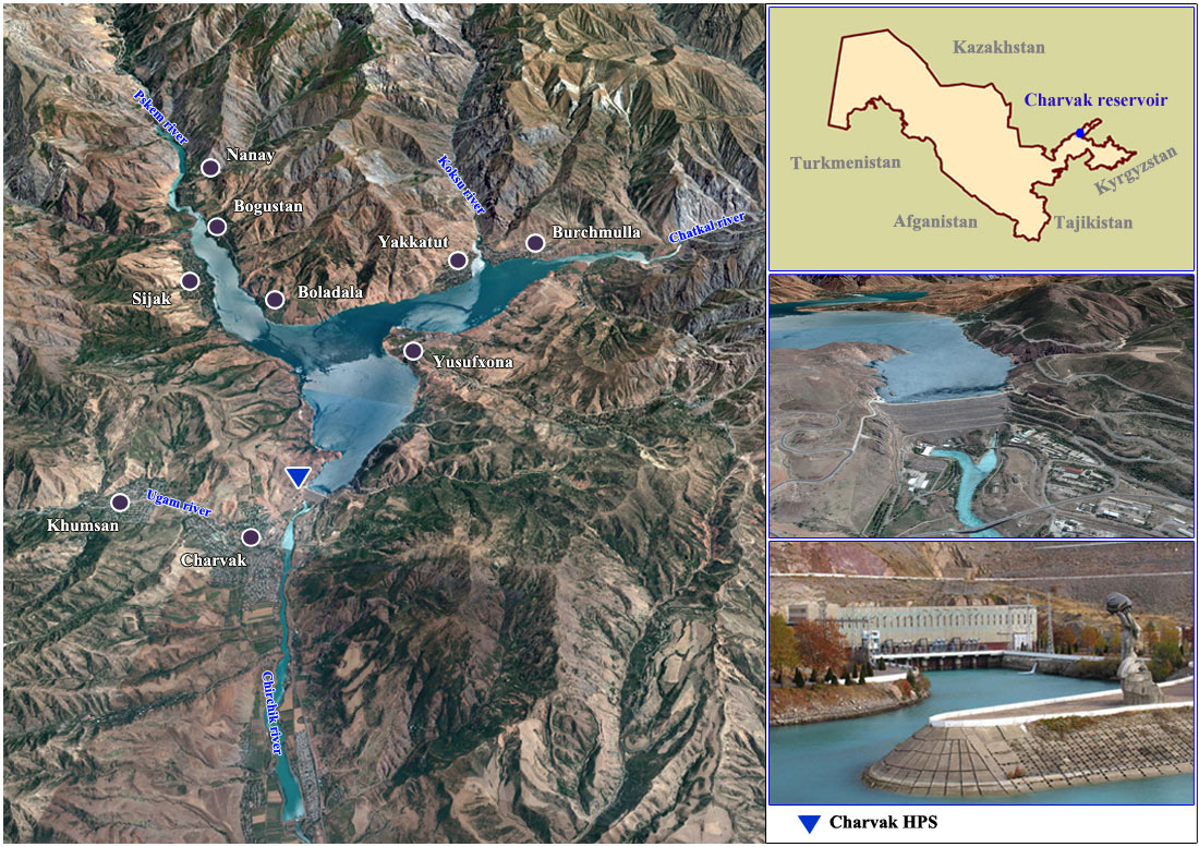
The area of the Chirchik River basin is 18,061 km2. length is 155 km, and from the source of the Chatkal - 328 km. The average flow rate is 221 m3/sec in the source. Before construction of the Charvak reservoir, the Chirchik River was formed by confluence of the two main rivers: the Chatkal – from the left side, and the Pskem – from the right side.
The Pskem River takes origin in the Talass Alatau glaciers that are numerous on the left head of the river called Maidantal. The river has a pebbly channel which incises into the ancient glacier valley. From its left side, a number of short tributaries originating from glaciers inflow to it. After confluence with the Oygaing – the largest left tributary of the Maidantal, - the river is called Pskem.
By changing its course to the west, the Pskem cuts through the high Turpakbel spur. Here, 8 km long, it forms a narrow and deep canyon between solid granites that rise absolutely sheer in some areas. Flowing out to the valley, the Pskem receives water from its last significant tributary, the so called Anaulgan, from the right, and changes again its course to the southwest and incises deep into conglomerations and red beds. The overall Pskem length starting from the Chatan streams is 120 km.
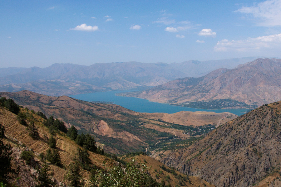
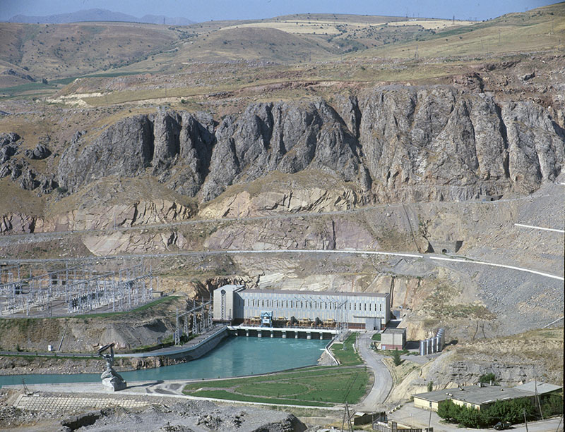
The reservoir of Charvak HPS is located in the Chirchik upstream. Upstream of the Gazalkent dam, on the average 183 m3/sec of water is delivered to the Chirchik-Bozsu cascade of power plants from the Chirchik, through the right upper diversion Bozsu canal; the Karasu canal diverts to the left upstream of the Troitskaya dam (discharge - 47 m3/sec); and downstream, the Chirchik feeds other canals.
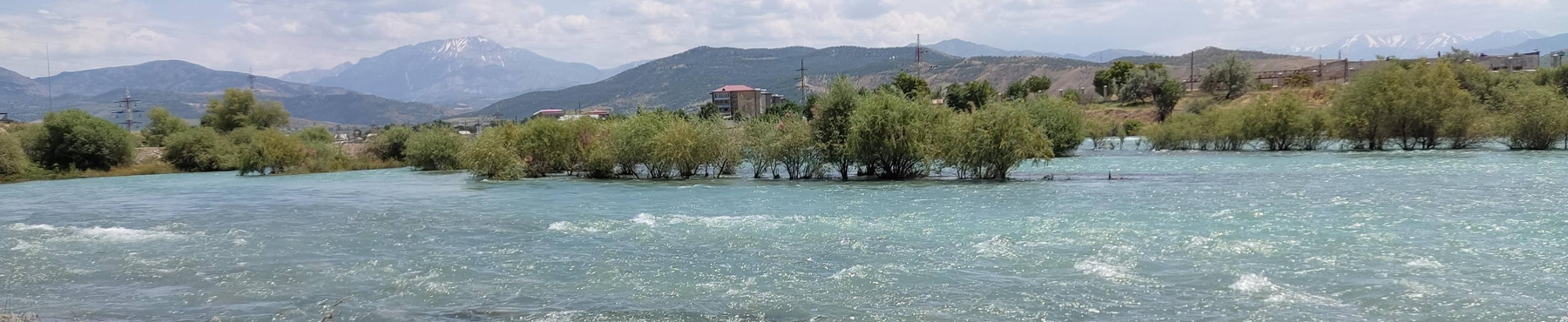
After the Charvak reservoir, only two rather large tributaries flow into the Chirchik – Ugam and Aksakatasay. The Chirchik flows in the canyon in the upper reaches (about 30 km), and its valley extends in the lower reaches and is poorly marked.
As soon as the Chirchik escapes to the plain, its water is intensively diverted for irrigation and hydropower generation, therefore, the river water content decreases. The river feeding is mixed, with domination of snow. Upstream of the Gazalkent dam, the Bozsu canal diverts to the right from the Chirchik, the Karasu canal diverts to the left upstream of the Troitskaya dam, the Chirchik feeds other canals downstream. The cities of Gazalkent, Chirchik, Tashkent; as well as rural settlements of Charvak, Iskander, Bektemir and Almazar are located in the river valley.
Average monthly values (water flowing into the Charvak reservoir)
Average values over 1980-2010, m3/s
| I | II | III | IV | V | VI | VII | VIII | IX | X | XI | XII | Average |
| 69 | 69 | 99 | 230 | 429 | 541 | 395 | 220 | 135 | 102 | 89 | 76 | 204 |
The Chatkal River originates in a snowy ravine of the southwestern Talass Alatau spurs, it is formed by the Karakaspa that flows down from the Karabura pass and by the Karakuldgy River that joins its waters in the junction point of the Chatkal ridge with Talass one. Up to the Idrispaygambara, the Chatkal flows in a wide ancient glacier valley. After joining the Sandalash on the right, its largest tributary, the Chatkal transforms into a vigorous river. Downstream of the confluence with the Ters, the Chatkal enters to a deep gorge where the stream gradient increases sharply.
Characteristics of water flow in the Chatkal River at the Ters River mouth
Average values over 1980-2010, м3/с
| I | II | III | IV | V | VI | VII | VIII | IX | X | XI | XII | Average |
| 29.3 | 28.7 | 28.7 | 53.6 | 107.9 | 148.1 | 113.2 | 67.9 | 49.1 | 37.0 | 32.4 | 65.9 | 63.5 |
Characteristics of water flow in the Aksakatasay River at the Karamazar rural settlement
Average values over 1980–1999, м3/с
| I | II | III | IV | V | VI | VII | VIII | IX | X | XI | XII | Average |
| 2.4 | 2.8 | 6.4 | 14.8 | 13.8 | 7.0 | 2.8 | 1.6 | 1.4 | 2.1 | 3.1 | 2.6 | 5.1 |
Characteristics of water flow in the Ugam River at the Khodjikent rural settlement
Average values over 1926-2010, м3/с
| I | II | III | IV | V | VI | VII | VIII | IX | X | XI | XII | Average |
| 8.9 | 10.4 | 20.4 | 49.7 | 58.7 | 51.2 | 30.8 | 15.2 | 10.5 | 9.7 | 10.3 | 10.1 | 23.8 |
Characteristics of water flow in the Chirchik River at the gauging station in Chinaz
Average values over 1926-2010, м3/с
| I | II | III | IV | V | VI | VII | VIII | IX | X | XI | XII | Average |
| 61.3 | 67.6 | 89.3 | 174.6 | 231.3 | 259.2 | 156.1 | 44.1 | 30.6 | 43.0 | 55.2 | 62.5 | 106.2 |
Source: SIC ICWC
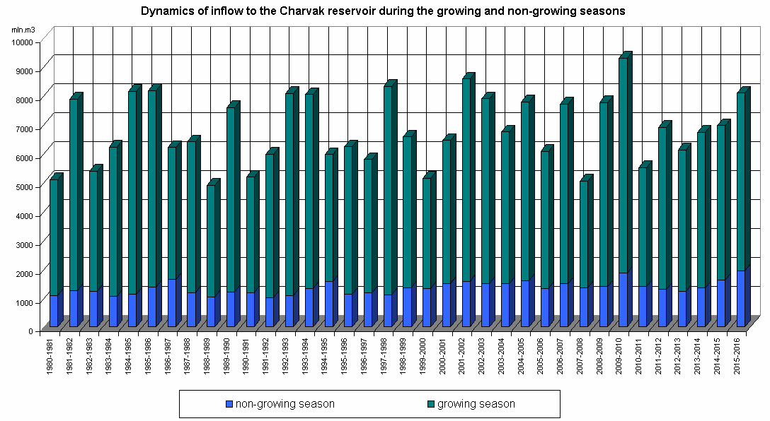
Dynamics of inflow to the reservoir during the growing and non-growing seasons
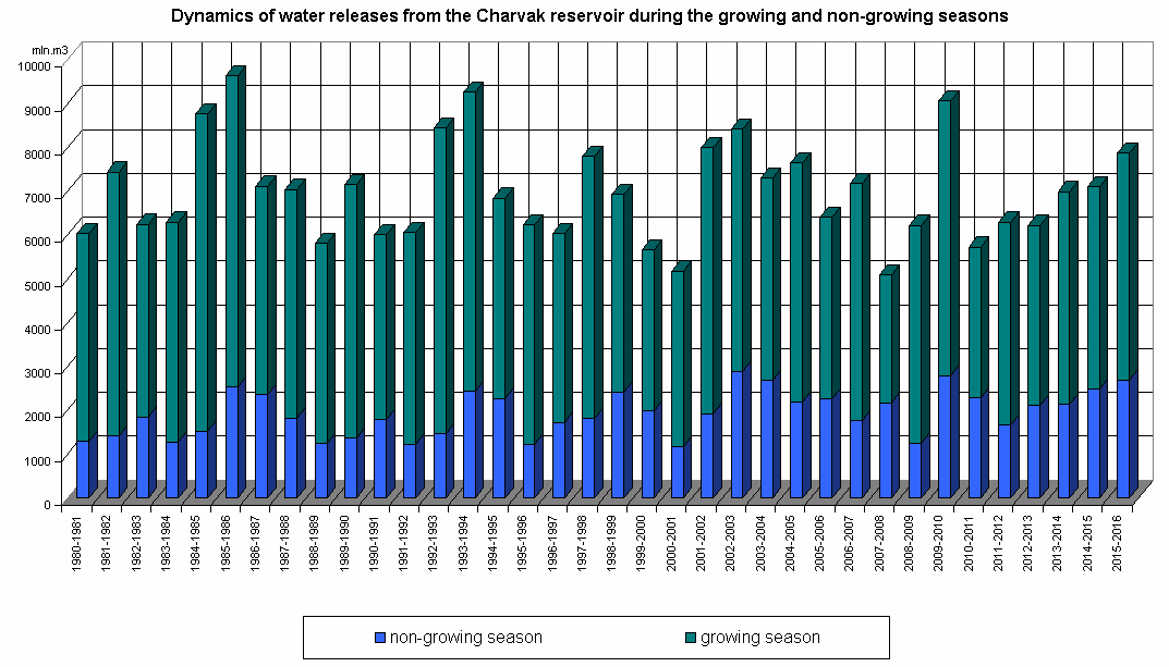
Dynamics of water releases from the reservoir during the growing and non-growing seasons
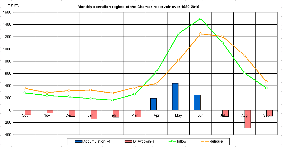
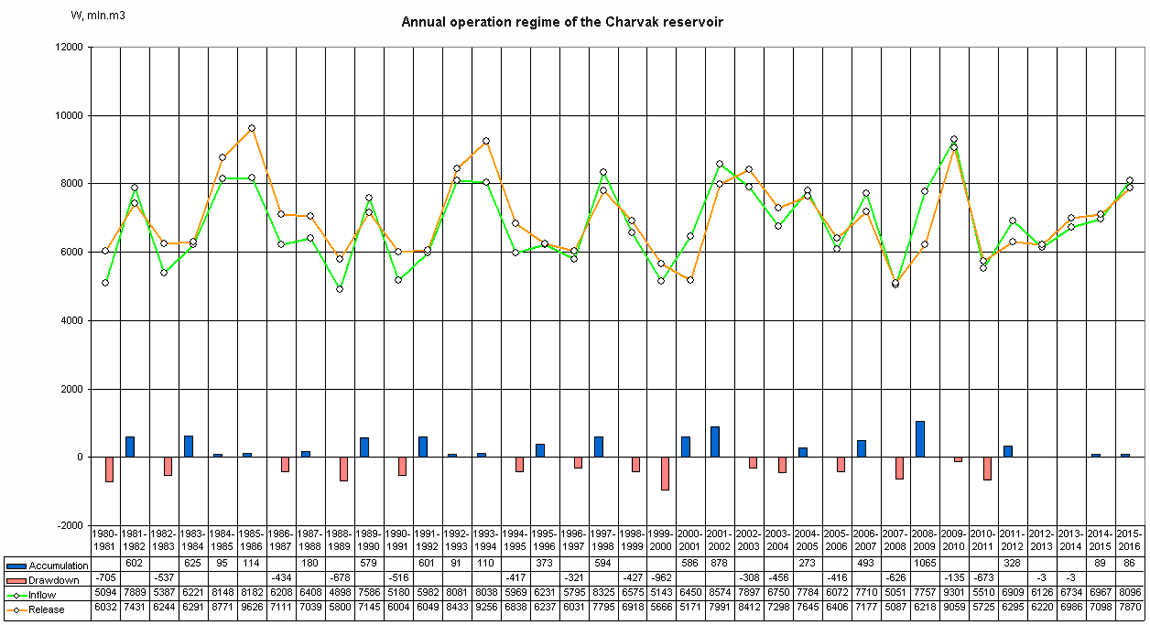
Monthly operation regime of the reservoir over 1980-2016
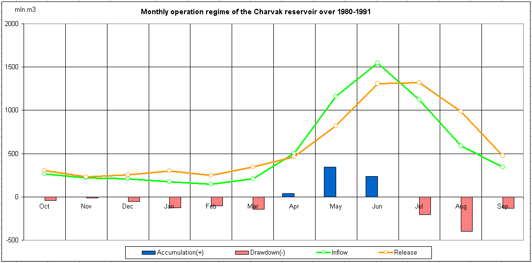
Monthly operation regime of the reservoir over 1980-1991
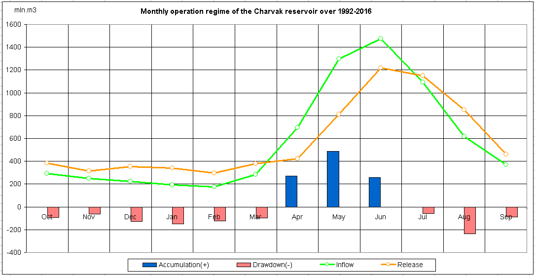
Monthly operation regime of the reservoir over 1992-2016