The Karadarya River is the left branch of the Syrdarya River flowing on the territory of Kyrgyzstan and Uzbekistan.
Its length is 180 km, the catchment area is 30.1 ths km2, and the mean flow rate is 120 m3/s.
It is formed by the confluence of the Karakudja and Tar rivers originating in the slopes of the Fergana and Alay ranges and flows westward. First, the Karadarya River flows through a wide valley in a multi-branching pebbled channel. Before escaping to the Fergana valley, the river breaks through the Kampyrravat gorge where it runs through a floodplain swamp here and there breaking up into several arms. Then it joins the Naryn River to form the Syrdarya.
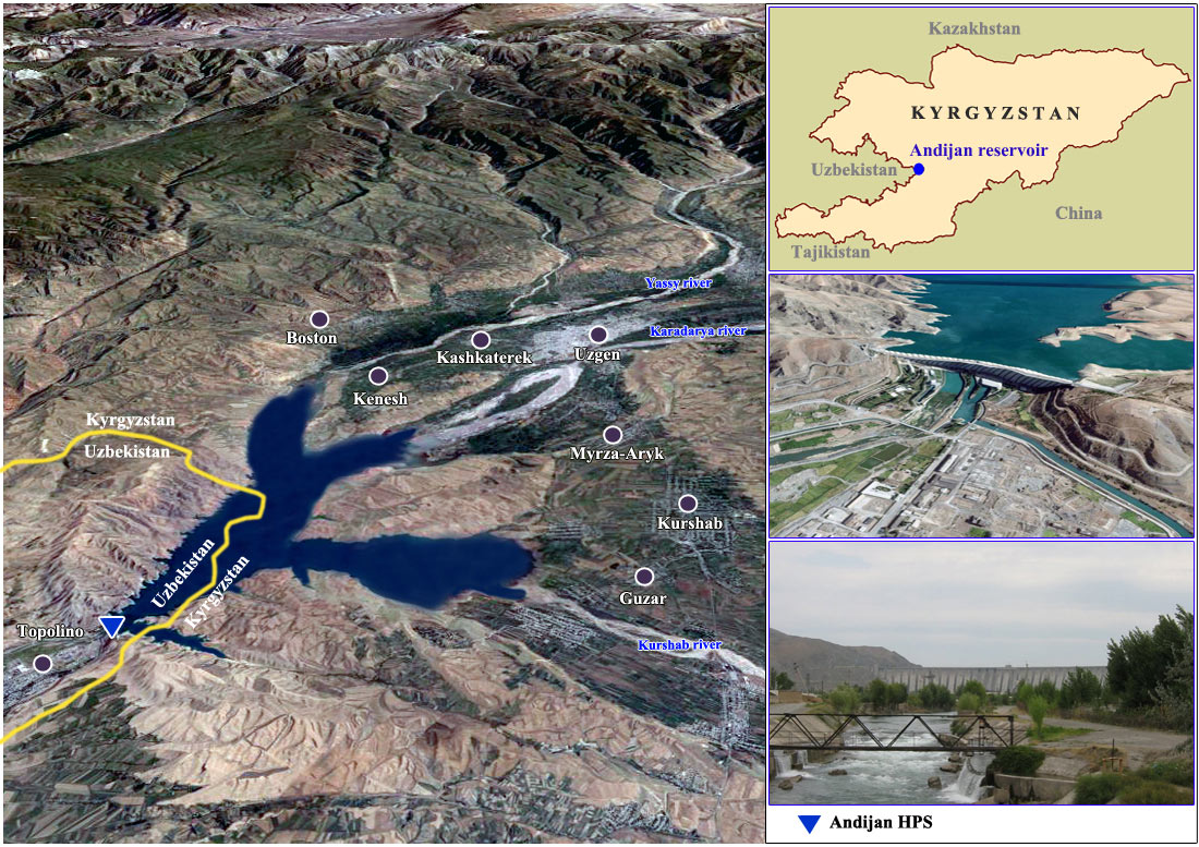
The river is snow and glacier-fed. Its peak flow takes place in June, and the lowest flow in winter. The river’s major tributaries are: Kurshab on the left side; Yassy, Kugart, and Tentaksay (Karaunkur) on the right. The Karadarya River is very important for irrigation. The Andizhan reservoir built in the river supplies water for irrigation in the Fergana Valley. In this Valley, Karadarya is dammed by the Kuygan-Yar dike and runs across the Big Fergana Canal.
Karakudja River’s flow rate, Aktash village
Mean values for the period of 1980-2010, m3/s
|
I |
II |
III |
IV |
V |
VI |
VII |
VIII |
IX |
X |
XI |
XII |
Average |
|
7.3 |
7.3 |
8.6 |
22.9 |
51.3 |
64.7 |
53.1 |
30.4 |
15.7 |
10.6 |
8.9 |
7.6 |
24.0 |
Tar River’s flow rates, Cholma village
Mean values for the period of 1980-2010, m3/s
|
I |
II |
III |
IV |
V |
VI |
VII |
VIII |
IX |
X |
XI |
XII |
Average |
|
13.8 |
13.4 |
15.9 |
38.4 |
83.6 |
124.3 |
107.5 |
62.2 |
31.4 |
22.4 |
18.4 |
15.7 |
45.6 |
Kurshab River’s flow rate, Gulcha settlement
Mean values for the period of 1980-2010, m3/s
|
I |
II |
III |
IV |
V |
VI |
VII |
VIII |
IX |
X |
XI |
XII |
Average |
|
9.0 |
8.6 |
9.4 |
15.7 |
35.6 |
48.3 |
42.4 |
26.4 |
17.8 |
13.3 |
11.8 |
10.2 |
20.7 |
Yassy River’s flow rate, Salamalik settlement
Mean values for the period of 1980-2010, m3/s
|
I |
II |
III |
IV |
V |
VI |
VII |
VIII |
IX |
X |
XI |
XII |
Average |
|
5.4 |
5.4 |
8.8 |
39.9 |
71.1 |
61.1 |
29.6 |
15.1 |
8.9 |
7.7 |
7.4 |
6.1 |
22.2 |
Kugart River’s flow rate, Mikhaylovskoe settlement
Mean values for the period of 1980-2010, m3/s
|
I |
II |
III |
IV |
V |
VI |
VII |
VIII |
IX |
X |
XI |
XII |
Average |
|
4.9 |
5.3 |
11.9 |
40.3 |
50.4 |
29.5 |
12.9 |
6.2 |
4.6 |
6.4 |
6.3 |
5.7 |
15.4 |
Karaunkursay River’s flow rate, Charvak settlement
Mean values for the period of 1980-2010, m3/s
|
I |
II |
III |
IV |
V |
VI |
VII |
VIII |
IX |
X |
XI |
XII |
Average |
|
11.6 |
12.3 |
19.3 |
56.4 |
81.3 |
69.7 |
42.3 |
28.8 |
15.3 |
13.7 |
13.1 |
12.6 |
31.4 |
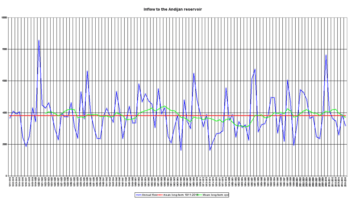
Karadarya River’s flow rate. Water inflow to the Andijan reservoir
Mean values for the period of 1980-2010, m3/s
|
I |
II |
III |
IV |
V |
VI |
VII |
VIII |
IX |
X |
XI |
XII |
Average |
|
50.0 |
49.6 |
63.2 |
158.4 |
284.1 |
307.6 |
197.5 |
94.2 |
56.1 |
57.7 |
64.2 |
59.2 |
120.1 |
Karadarya River’s flow rate. Uchtepa gauging station
Mean values for the period of 1980-2010, m3/s
|
I |
II |
III |
IV |
V |
VI |
VII |
VIII |
IX |
X |
XI |
XII |
Average |
|
112.8 |
107.9 |
111.3 |
153.5 |
176.8 |
166.9 |
123.4 |
108.7 |
92.2 |
116.4 |
143.9 |
144.8 |
130 |
Source: SIC ICWC
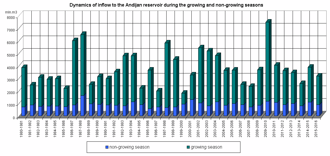
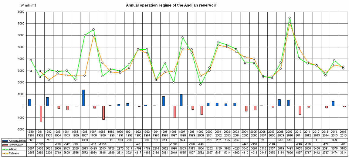
Dynamics of inflow to the reservoir during the growing and non-growing seasons
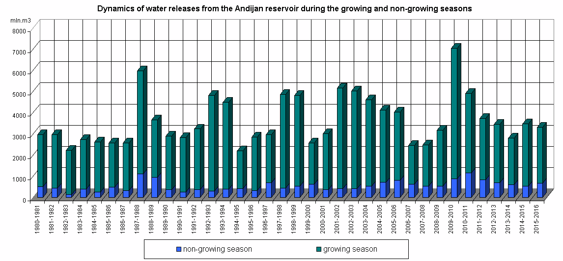
Dynamics of water releases from the reservoir during the growing and non-growing seasons
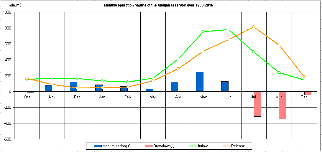
Monthly operation regime of the reservoir over 1980-2016
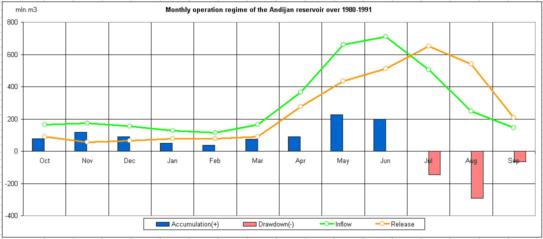
Monthly operation regime of the reservoir over 1980-1991
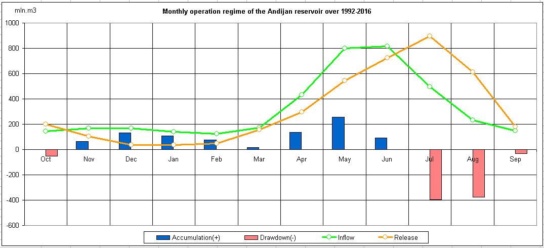
Monthly operation regime of the reservoir over 1992-2016