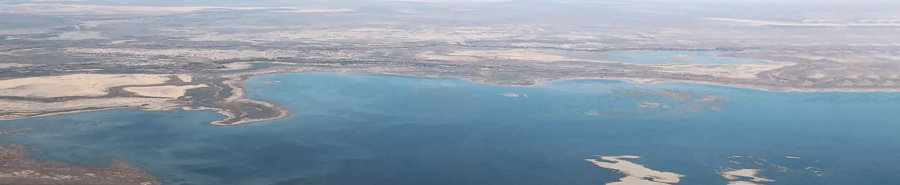
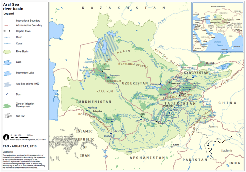
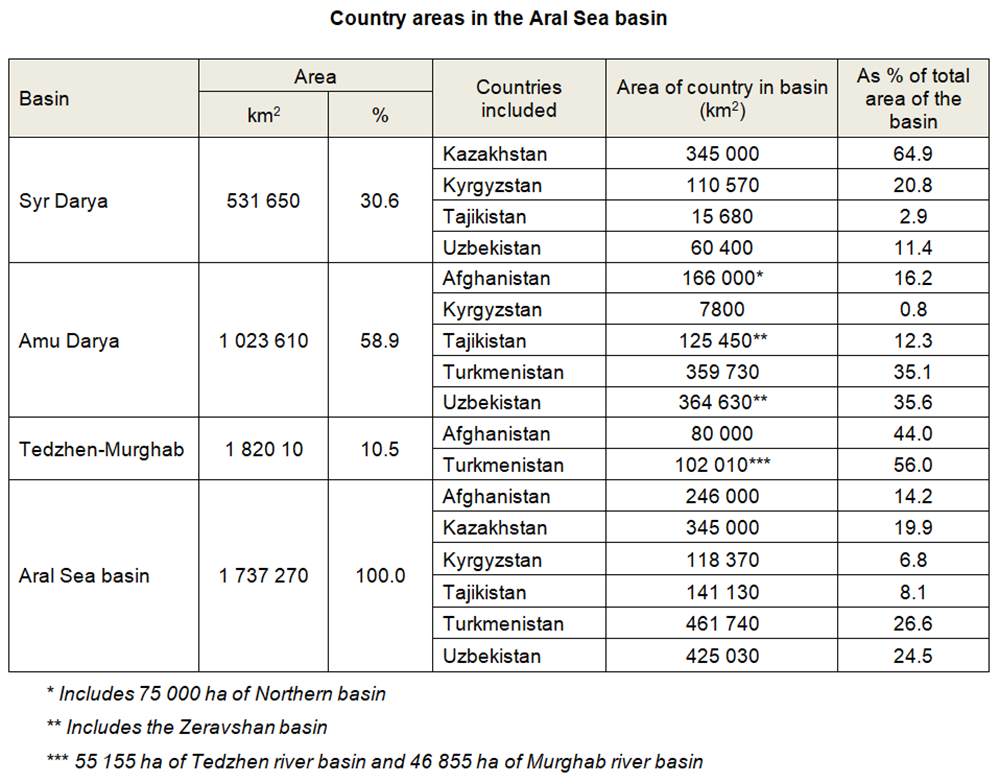
The Aral Sea basin, which geographically coincides with almost the entire area of Central Asia, is located in the heart of the Euro-Asian continent. More specifically, the Aral Sea basin covers the whole territory of Tadjikistan, Uzbekistan, the majority of Turkmenistan, three provinces of the Kyrgyz Republic (Osh, Jalalabad and Naryn), and the southern part of Kazakhstan (two provinces: Kyzyl-Orda and South Kazakh), and northern part of Afghanistan and Iran. For the purpose of this presentation, only the provinces of the first five countries within the Aral Sea Basin have been taken into consideration. This territory extends between longitudes 56o and 78o East, and latitudes 33o and 52o North, covering an area of about 1737,27 thousands km2.
Source: Transboundary River Basin Overview – Aral Sea
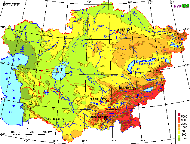
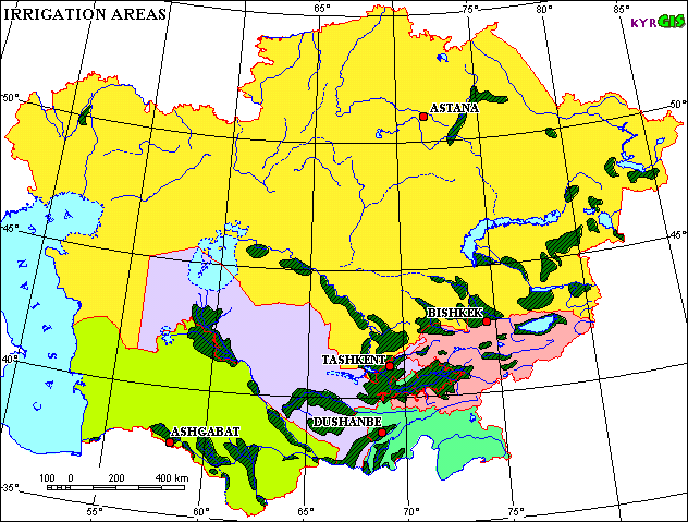
The territory of the Aral Sea Basin can be divided into two main zones: the Turan plain and the mountain zone. The Kara Kum covers the western and the northwestern parts of the Aral Sea Basin within the Turan plain and Kyzyl Kum deserts. The eastern and south-eastern parts are situated in the high mountain area of the Tien Shan and Pamir ranges. The remaining part of the basin is composed of various types of alluvial and inter-mountain valleys, dry and semi-dry steppe. Different forms of relief in all the countries have created specific conditions, which are reflected by the interrelation between water, land and populated area within the region. About 90% of the territory of the Kyrgyz Republic and Tajikistan are occupied by mountains. This, on the one hand, creates for these two countries a "monopoly" on the formation of water within the basin and, on the other hand, a deficit of cultivable lands. The most important feature of the region is the number of oasises (Fergana Valley, Khorezm, Tashaus, Mary, Zerafshan, Tashkent – Chimkent), which cover a small part of the overall area, but since ancient times have been the focus of human activity and population due to the presence of acceptable living conditions (water, precipitation, the best soils, etc).
The majority of the territory of Kazakhstan, Turkmenistan and Uzbekistan are covered by desert (more than 50%), and only less than 10% is represents by mountains. Such distribution of area has created a huge potential for the development of irrigation, which requires more water resources than those countries have available. This unequal allocation of water and land were seen in Soviet times as an opportunity to re-allocate the water resources for the development of newly irrigated area in lowland republics. However, in the current post Soviet period these circumstances have been transformed into a source of potential future conflicts.
The landlocked position of Central Asia within the Euro-Asian continent determines its sharply continental climate, with low and irregular precipitation. Large daily and seasonal temperature differences are characteristic of the region, with high solar radiation and relatively low humidity. Diverse terrain and altitude differences from 0 to 7,500 m above sea level lead to a great diversity of microclimate. Mountains are located in the east and southeast, which are the center for the formation of water and the origin of its flow. Although this area is often struck by humid winds, the mountains trap most of the moisture, leaving little precipitation for the other areas of the Aral Sea Basin.
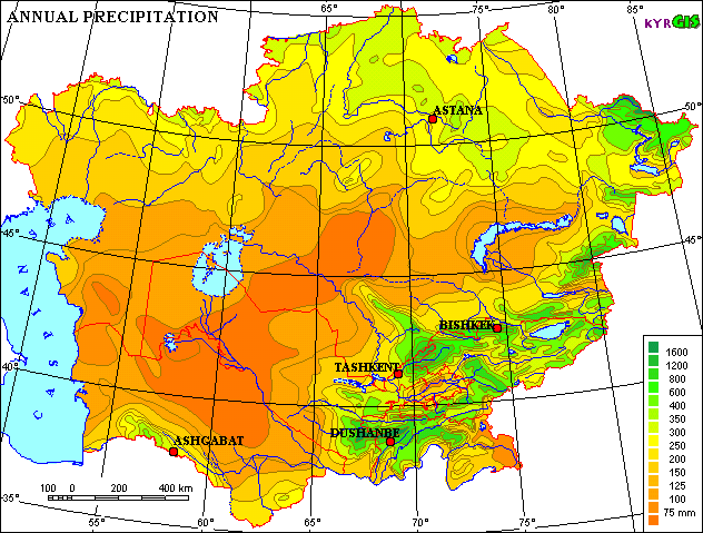
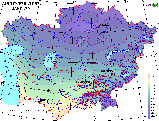
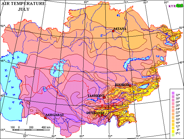
The average July temperature on the lower elevations, in valley areas and desert, deviates from 26oC in the north to 30oC in the south, with maximum temperature up to 45-50oC. The average January temperature records are up to 0oC in the south to -8oC in the north with absolute minimum up to -38oC. The annual precipitation in the lowland and valleys is between 80-200 mm, concentrated in the winter and spring, while in the foothills precipitation is between 300-400 mm, and on the southern and south-western sides of the mountain ranges between 600-800 mm.
Climate in the region has specific zones of variation accordingly to geographic and geomorphologic conditions, which define the difference in water demands for irrigation. Big differences in air humidity in summer time between the old oasises and newly irrigated area (50-60% and 20-30%) cause significantly larger water demands in former desert (now under irrigation) in comparison with oasis’s. The second factor especially affecting agricultural production is the instability of spring weather, which deviates in temperature, precipitation and even late frosts (sometimes in the beginning of May) and hail (in June, which sometimes destroys emerging cotton plants and vegetables over big areas).
Scheme of the Climatic Zones in the Aral Sea basin
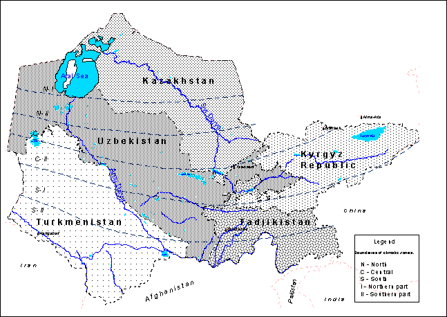
The water resources in the Aral Sea region consist of renewable surface and groundwater, as well as return water from anthropogenic use (wastewater and drainage water). There are two major river basins located in the Aral Sea Basin: the Syrdarya in the north, and the Amudarya in the south. The Zeravshan river, a former tributary of the Amudarya, has a position between these two major rivers.
A feature of the region is the division of it's territory into three main zones of surface runoff:
(a) the zone of flow formation (upper watersheds in the mountain areas),
(b) the zone of flow transit and it’s dissipation,
(c) the delta zones.
As a rule, there is not a significant level of anthropogenic changes in the zone of flow formation, but due to construction of big dams and water reservoirs on the border of this zone, the downstream run-off regime is changing significantly. Within the zone of flow transit and dissipation the run-off and the whole hydrological cycle are changing in consequence of interaction between rivers and territory. This interaction is characterizing by water withdrawal from river to the irrigated areas and the loading of return flow to the river with salt and agricultural chemicals.
In terms of water availability the Syrdarya is the second most important river in Central Asia but the largest in terms of length. From the Naryn headwaters its length is 3019 km, with a catchment area of 219 thousands km2. Its headwaters lie in the Central (Interior) Tien-Shan mountains. The river is known as the Syrdarya after the point where the Naryn joins with the Karadarya. The river has glacial and snow feeding, with a prevalence of the latter. The water regime is characterized by a spring-summer flood, which begins in April. The largest discharge is in June. About 75.2% of the Syrdarya run-off originates in the Kyrgyz Republic. The Syrdarya then flows across Uzbekistan and Tajikistan and discharges into the Aral Sea in Kazakhstan. About 15.2% of the flow of the Syrdarya is formed in Uzbekistan, about 6.9% in Kazakhstan, and about 2.7% in Tajikistan.
The Amudarya is the biggest river in Central Asia. Its length from the headwaters of the Pyandzh to the Aral Sea is 2540 km, with a catchment area of 309 thousands km2. It is called Amudarya from the point where the Pyandzh joins with the Vaksh. Three large right tributaries (Kafirnigan, Surhandarya and Sherabad) and one left (Kunduz) flow into the Amudarya river within the middle reach. Further downstream towards the Aral Sea it has no tributaries. It is fed largely by water from melted snow, thus maximum discharges are observed in summer and minimum ones in January-February. Such availability of the flow within a year is very favorable to the use of the river water for irrigation. While crossing the plain, from Kerky to Nukus, the Amudarya loses the majority of its flow through evaporation, infiltration and withdrawal for irrigation. In terms of sediment the Amudarya carries the highest load of all the rivers in Central Asia and one of the highest levels in the world. The main flow of the Amudarya river originates on the territory of Tajikistan (about 74 %). The river then flows along the border between Afghanistan and Uzbekistan, across Turkmenian territory and then again returns to Uzbekistan where it discharges into the Aral Sea. About 13.9% of Amudarya water is formed on Afghan territory and in Iran. About 8.5% of the Amudarya flow is formed in Uzbekistan.
The total mean annual flow of all rivers in the Aral Sea Basin is estimated as about 116.48 km3. This amount comprises the flow of the Amudarya at 79.2 km3/year and the Syrdarya at 37.2 km3/year. In accordance with flow probabilities of 5% (high wet years) and 95% (dry years), the annual flow ranges from 109.9 to 58.6 km3 for the Amudarya river, and from 54.8 to 26.5 km3 for the Syrdarya river, respectively.
Surface water resources in the Aral Sea basin (mean annual runoff, km3/year)
|
Country |
River Basin |
Total Aral Sea Basin |
||
|
Syrdarya |
Amudarya |
km3 |
% |
|
|
Kazakhstan |
2.426 |
— |
2.426 |
2.1 |
|
Kyrgyzstan |
27.605 |
1.604 |
29.209 |
25.1 |
|
Tajikistan |
1.005 |
59.578 |
60.583 |
52.0 |
|
Turkmenistan |
— |
1.549 |
1.549 |
1.2 |
|
Uzbekistan |
6.167 |
5.056 |
11.223 |
9.6 |
|
Afghanistan and Iran |
— |
11.593 |
11.593 |
10.0 |
|
Total Aral Sea basin |
37.203 |
79.280 |
116.483 |
100 |
Source: Sokolov V.I. Delineation of the boundaries of transboundary, local, and mixed-type surface water catchments in the Aral Sea basin and their quantitative assessment // Development of key components of ICWC policy on rational water use and water protection in the Aral Sea basin (Collected papers of SIC ICWC, Issue 2, 2000)
The groundwater resources of the Aral Sea basin can be divided into two parts: the natural flow from mountainous and water catchment area and groundwater originated by filtration from hydrotechnical structures and irrigated land. On the whole 339 aquifers were prospected and approved as sources permitted for exstraction within the region. Estimated regional reserves are about 31.17 km3, of which 14.7 km3 are located in the Amudarya basin and 16.4 km3 in Syrdarya basin. Because exploitation of groundwater can have an impact on surface water flows, the quantification of groundwater resources must be careful carried out to identify the portion of the reserves that can be used without significantly diminishing surface runoff. The reserves confirmed for extraction are estimated at 13.1 km3 per year.
Total actual groundwater extraction in the Aral Sea Basin was about 10.0 km3. The quality of groundwater in the region varies by salt content from 1 to 3 g/l. Almost half of the common volume of groundwater is sufficient for domestic needs, and approximately 70% for agriculture. A considerable part (about 30%) of regional groundwater has a transboundary nature, and its usage requires interstate consideration and mutual regulation.
Groundwater reserves and use in the countries within the Aral Sea basin (million m3 per year)
|
Country |
Estimated regional groundwater reserves |
Reserves confirmed for extraction |
Total actual extraction |
Including different users and purposes |
|||||
Domestic water supply |
Industry |
Irrigation |
Vertical drainage wells |
Pumping tests |
Other |
||||
|
Kazakhstan |
1846 |
1224 |
420 |
288 |
120 |
0 |
0 |
0 |
12 |
|
Kyrgyzstan |
862 |
670 |
407 |
43 |
56 |
308 |
0 |
0 |
0 |
|
Tajikistan |
6650 |
2200 |
990 |
335 |
91 |
550 |
0 |
0 |
14 |
|
Turkmenistan |
3360 |
1220 |
457 |
210 |
36 |
150 |
60 |
1 |
0.15 |
|
Uzbekistan |
18455 |
7796 |
7749 |
3369 |
715 |
2156 |
1349 |
120 |
40 |
|
Total Aral Sea basin |
31173 |
13110 |
10023 |
4245 |
1018 |
3164 |
1409 |
121 |
66 |
Return water constitutes a high proportion of water resources in the basin and are also a major source of pollution. In recent years, the annual mean values of return flows, consisting of drainage and wastewater from irrigation, industry, and municipal users have varied between 28.0 km3 and 33.5 km3. About 13.5 to 15.5 km3 annually form in the Syrdarya basin, and about 16 to 19 km3 in the Amudarya basin. The total amount is comprised of about 95% of drainage water and about five percent of untreated domestic and industrial wastewater. The large percentage of drainage water demonstrates that irrigation actually consumes only about 45-50% of total withdrawals.
Drainage water involves two components: The surface component consists of the outflow from irrigated fields, losses from the irrigation network, and water pumping from the vertical drainage system. The subsurface component of these waters consist of infiltration from irrigated fields and the infiltrated water from irrigation networks that reach the collector-drainage system. Minimization of losses is one of the principal goals for water managers. Drainage water is highly saline, from 2 to 3 g/l from April to September, and 5-12 g/l during autumn and winter periods. The quality of the drainage effluent depends on the location of the irrigation scheme within the river basin (upper, middle, or lower reaches) and the leaching requirements of the irrigated area. It also depends on the use of agro-chemicals. The local salt mobilization is determined in part by the type of the drainage system (open, subsurface or vertical), seepage, drain spacing, and drain depth. The poor quality creates limitations for the re-use of drainage water, especially for irrigation. Only about 15% of total return flows are re-used and more than 55% returns to rivers. About 30% end up in natural depressions, from which the water evaporates.
The prosperity of Central Asia, as an agrarian region from ancient times, was always very closely interrelated with land use. From this point of view the fertile soils formed the framework for prosperity for the working population. Out of the total land resources of about 154.9 million hectares some 59.1 million hectares are considered as cultivable, of which only about 10 million hectares are actually used. Half of the actually cultivated lands are located in the oasis’s (they are naturally drained, with fertile soils). The other half of the land requires for their use a complicated and expensive set of reclamative measures, including not only drainage and leveling, but also improvement of soil structure. Distribution of lands among the countries shows a big inequity, characterized by good land availability in Kazakhstan and Turkmenistan and land scarcity for the three other countries.
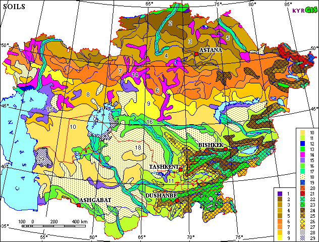
1 Leached and Podzolized Chernozems 2 Usual Chernozems 3 Southern Chernozems
4 Dark - Chestnut and Chestnut Soils 5 Association of Dark- Chestnut and Chestnut Soils with Solonetzs
6 Light - Chestnut often Solonetz-Like Soils 7 Association of Light -Chestnut Soils with Solonetzs
8 Brown Semidesert often Solonetz-Like Soils 9 Association of Brown Semidesert Soils with Solonetzs
10 Association of Brown Semidesert Soils 11 Sierozems on the Sizeable Areas Transformed by the Irrigation
12 Bog Soils 13 Associations and Combinations of Meadow - Chernozem Soils, Solonetzs and Solods
14 Soil Associations with Solonetzs Predominance 15 Solonchaks often in Combination with Solonetzs
16 Combinations of Takyr Soils and Takyrs 17 Alluvial Soils and Meadow Soils
18 Sands and Weak Developed Sand Soils 19 Mountain Tundra Soils 20 Mountain Podzolic Acid Unpodzoled Soils
21 Mountain Gray Forest Soils 22 Mountain Meadow Soils 23 Mountain Meadow - Steppe Soils
24 Mountain Chernozems and Mountain Chestnut Soils 25 Mountain Cinnamon and Mountain Gray - Cinnamon Soils
26 Mountain Sierozems 27 High Mountain Desert Soils 28 Glaciers
29 Areas Appeared Due to Shrinkage of Caspian and Aral Seas