The tragedy of Aral Sea disappearance is one of the most convincing and vivid cases against unbalanced activities undertaken by the human society neglecting sustainable development, which are so numerous in the creative and simultaneously destructive latter half of the 20th century. During this period the humanity not only had the unprecedented achievements in engineering development, but also damaged the nature more than ever. Such a predatory outrage upon the planet was caused by the impetuous technological revolution, which at that time had been declared as a watershed of the human history, until the most advanced people found that very grave environmental consequences were hidden behind its frontage.
Almost all current global climatic, hydrological, and geological cataclysms (not only in the former socialistic countries) - the green-house effect, losses of rivers, lakes and wetlands, wide-spread desertification are caused by ambitious aspiration of people as if to provide their well-being, but in fact mainly for increasing property, domination and power, and followed by disregard of the fact that everything in the world is interdependent and has its own consequences in the form of large scale disturbance or transformations of natural processes. Some countries in the West recognized the necessity "to be respectful to the nature and to repay their debts to it" as early as the 1970s and 1980s, and in that time the community in the USSR just began thinking about ecological problems and has seen things clearly only when being on the verge of its collapse.
At present, the peoples and governments of such countries as Canada, the Netherlands, France, Switzerland, and Japan, which set an example for all mankind how to establish the interrelations with the nature, are worthy of gratitude and respect. They demonstrate how to integrate urbanization with preservation of fauna, flora, and landscapes on the basis of harmonizing interests of economic development and demographic growth with the environmental requirements and even raising a nature potential. In these countries, a partnership of people with the nature is based on profound respect and pride for natural resources belonging to their states, and worship of the nature which is inculcated from childhood.
Drying up the Aral Sea that was a large water body with good quality water has reached such an extent that widespread nature degradation inside the dried area (at elevations less than 53 m + BSL) and outside its boundaries has resulted in the situation when this region is the natural disaster zone. The sea, which was the habitat of abundant flora and fauna and a natural regulator of climate in the adjacent irrigated area, degrades to such an extent that the desertification zone located between deserts Kyzylkum, Karakum and Usturt is formed. Vast areas of solonchaks and strongly saline lands, being sources of salt and dust transfer due to wind erosion, have occurred here.
In the coastal zone (above the elevation of 53 m + BSL) the ecosystem of the delta and a coastal zone, which was formed during many centuries was completely damaged; the lakes dried up, salinity of water increased; solonchaks appeared at the sites of the dried marshes; catch of fish and furry animal significantly diminished; migratory birds disappeared; flora and fauna degrade; and the local climate undergoes a change.
The five independent states located in the Aral Sea basin — Kazakhstan, Kyrgyzstan, Tajikistan, Turkmenistan and Uzbekistan — have properly evaluated the necessity of tackling the problem of the Aral Sea and Prearalie (a dried coastal zone). The Heads of these states approved the Concept, in which the proposal to establish a new sustainable anthropogenic-natural complex in the South Prearalie in order to rehabilitate the productivity of this territory as much as possible was formulated. However, due to economic decline after disintegration of the USSR, implementation of this program faces difficulties.
The existing ecological situation is of great concern for all peoples living both inside and outside the Aral Sea basin. As a result, there have appeared many plans and proposals in order to solve, to a greater or lesser extent, the following issues:
• protecting the population from adverse impacts of desertification;
• restoring fauna and flora diversity to a maximally possible extent;
• creating workplaces for the local population by means of rehabilitation of fishery, muskrat breeding, cattle breeding, processing sectors, etc.;
• creating appropriate social and economic conditions necessary for improving the local standard of living by means of introducing high-yielding technologies in the field of water and land resources use;
• preventing further degradation of the environment, and rehabilitation the environmental balance in the South Prearalie.
Formerly, these issues had been addressed in two interrelated sustainable ecological zones (the Aral Sea and Prearalie) based on a certain hydrological regime of the Amu Darya and Syr Darya rivers. Social-economic activity in the vicinity of the sea and in deltas had been tightly related to the water regime of these zones and their peculiarities and not intervened significantly in natural conditions. At present, it is necessary to rehabilitate the former situation as much as possible and to direct developing negative trends conversely. Numerous donors tried to assist the “disaster epicenter”, but they were not based on the integrated approach. Real actions were undertaken under support of the International Fund for the Aral Sea (IFAS) and the GEF, which initiated the projects for rehabilitating wetlands (the Sudoche Lake Rehabilitation Project) and some water bodies.
Despite the fact that since the beginning of the past millennium many scientific volumes were devoted to the Aral Sea, its chronology remains contradictory and unclear. Since the second half of the nineteenth century the Aral Sea has become an object of numerous field studies conducted by the Russian Geographical Society and different scientific organizations of Russia. In 1908, the results of these studies were summarized by L. Berg in his great work “The Aral Sea Chronology Studies”, where he stated that none of Greek or Roman authors had directly or indirectly mentioned the Aral Sea, however, most of them had told about Oksa (Amu Darya) and Aksart (Syr Darya), at the same time, it remains unclear which water bodies they emptied into. According to the famous scientist Al Beruni from Khorezm, who died in 1048, the inhabitants of Khorezm, keeping their chronology since 1292 B.C., attested the existence of the Aral Sea. L. Berg has referred to the Holy Book of Avesta, in which it was mentioned that the Vakhsh or the present Amu Darya River flowed into Lake Varakhsha, which some people had in mind as the Aral Sea. The first more or less reliable sources regarding the existence of the Aral Sea pertain to Arabic scripts, which recorded evidences of the conquerors of Khorezm in 712 A.D. These reports that were well described by V.V. Bartold confirm that the Aral Sea has already existed in the eighth century and was located not far from Khorezm, as its description fully coincides with features of the eastern coast of the Aral Sea. Other evidences belong to Massudi ibn Nurusti, Al Balkhi and many other Arabic writers and investigators-geographers.
Geological surveys carried out at the end of the nineteenth century and the beginning of the twentieth century (А.М. Konshin, P.M. Lessor, and V. Obruchev), have proved that in the post-Pliocene epoch the part of the Karakum Desert between cliffs of the Usturt Plateau in the north and the mouths of the Murgab and Tedjen rivers in the south, and the Kopetdag Mountain foot in the west had been flooded by the Big Aral Sea. The eastern half of the united Caspian-Aral Sea had, in their opinion, a cliff of the Unguz shoreline as the border of the former Karakum Bay. This united sea had covered a wide strip of the present pre-Caspian area right up to a foot of the western Kopetdag ridges, and linked with Karakum and Chilmetkum bays by two straits - the Bolshoy Balkhskiy and Maliy Balkhskiy. At that time the Aral part of the united sea flooded entirely the Sarykamysh depression and formed the bay stretched out to the Pitnyak, which is now occupied by the present-day delta of the Amu Darya and the Khiva oasis (as well, this explains the presence of salts deposit at the Pitnyak). The Uzboy Strait had linked both water areas, but it is obvious that its form with steep slopes arose due to separation of the Caspian Sea from the Aral Sea and increase in their water surface elevations. During the subsequent geological epoch and to our time, division of the united Aral-Caspian into its component parts and its gradual reduction up to the current boundaries took place. At first, the watershed between the Aral-Sarykamysh and the Caspian Sea at Balla Ishem on the Usturt Plateau formed, and then the Uzboy river channel gradually developed. The sequence of desiccation is confirmed by layers of transition deposits from the latest Caspian mollusks burials (along the former Uzboy river, in the sands of the Chilmetkul, and along the south-eastern shoreline of the Caspian Sea) covered by incoherent sands with sparse and young vegetation to ancient formations in the Central Karakum Desert, which have transformed into sors (deposits of super-salty water bodies under drying up), takyrs, compacted sand hills overgrown with woody vegetation. Sors, being the lowest places of the sea bottom and fed by saltish artesian water, kept the pattern of ancient coastal lakes.
Since the ancient times, all the researchers and historians were describing transformations of the Aral and Caspian seas depending on water availability and irrigation development in their united drainage basin. They have confirmed the fact of complete desiccation of the Sarykamysh Lake by the end of the sixteenth century, when inflow of the Amu Darya River into the Sarykamysh Lake via the Kunya-Darya, Daudan and Uzboy rivers had stopped. At the section from the Caspian Sea to the Bally Item watershed, the Uzboy channel is lifting by 40 m at a distance of more than 200 km. According to V. Obruchev, the existence of the Sarykamysh Lake took place during the period since the VII century B.C. till the XVI century A.D. On the way to Khiva, in 1559, Jenkinson has observed the presence of the Sarykamysh Lake, which he recognized as the inflow of the Oksus into the Caspian Sea. He also relied on the similar evidences of Abdulghazi-Khan, Ghamdudla and other chroniclers of Khorezm.
The Aral-Caspian lowland was sketched out in many maps thoroughly analyzed by Rene Letal and Monica Mainglo in their excellent monograph "Aral". All trends of the Aral Sea migration are tracked in succession of maps drawn in accordance with human perception starting with the “Geography” by Ptolemy (the 2nd century A.D.), on which the Caspian Sea was depicted in all its greatness and without any reference to the Aral Sea (Figure 1), then on the layout of Al Idrisi (1132 A.D.), (Figure 2) and “Catalan Atlas” (1352 A.D.) (Figure 3), where the Aral Sea is sketched out, and ending with the map drawn by Butakov, on which the Aral Sea was already shown in the well-known form (Figure 4).
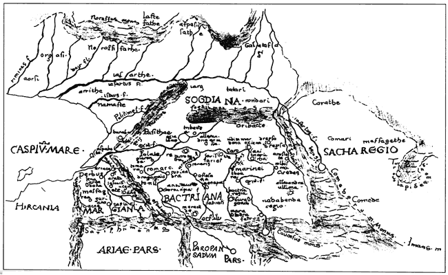
Figure 1. A Map from Ptolemy's "Geography"
Figure 2. A Layout by Al Idrisi
Figure 3. A layout from the Catalan Atlas
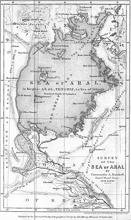
Figure 4. Butakov's Map
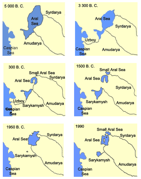
Based on geological and historical investigations, most researchers (B.V. Andrianov, А.S.Kes, P.V. Fedorov, V.A. Fedorovich, Y.G. Maev, I.V. Rubanov, A.L. Yanshin and others) have came to the almost unanimous conclusion, which was well formulated by N.V. Aladin: “in prehistoric times, changes in the Aral Sea level and salinity took place due to natural climatic changes”. During the humid climatic phase the Syr Darya and Amu Darya rivers were abounding in water, and the lake reached the maximum level of 72 to 73 m +BSL.
In contrast to that, in arid climatic phases both rivers became containing little water, the Aral Sea level also dropped, and the salinity level increased. In historical times, during the existence of the ancient Khorezm, the changes in the water level depended to some extent on climate change, but mainly on irrigation activity in the basins of two rivers. In the periods of intensive development of the countries adjacent to the Aral Sea, the increase in irrigated areas resulted in withdrawal of most of water for this purpose, and the sea level had immediately dropped. Unfavorable periods (wars, revolutions, etc.) in the region were followed by reduction of irrigated lands, and the rivers filled up again.
Geological and hydrological surveys, carried out by А.P. Kes and a number of the prominent geographers in the 1980s, showed that the Amu Darya and Syr Darya rivers changing regularly their flow direction and migrating throughout Central Asian in the historic period have not often reached the Aral Sea, and as a result the sea has dried up and a desert zone has formed on its territory. At the same time, as the sea was drying up, water salinity was considerably increasing and promoting precipitation of salts, which were found by the geologists at the bottom of the Aral Sea. Thick layers of mirabilite precipitations are especially impressive. The migration of both the Amu Darya and Syr Darya deltas has established a very peculiar downstream area, where the depressions filled with boggy deposits alternating with deserted, fine-silty, and sandy deposits that formed the delta and the most part of the Amu Darya River bed itself and its branches. On the other hand, the field studies carried out by zoologists, in particular, by Polishchuk and Aladin from the Zoological Institute under the Academy of Sciences of USSR in 1990 have shown that the Aral Sea itself is characterized by very poor original fauna and the absence of many species that are in the Caspian Sea which is similar according to its origin. At the same time, endemic species were found in the Aral Sea indicating that salinization of the Aral Sea, which took place from time to time affected these large-scale transformations.
Development of periodic fluctuations in the water area of the Aral Sea
over the period from 10000 B.C. to 1990
The analysis carried out by zoologists has shown that a small number of marine and oceanic species remained in the Aral Sea; however communities of brackish water species including the Caspian-estuary fauna have been destroyed here. All the rivers emptying into the Aral Sea have not retained marine fish species or, at least, remains of this fauna. It means that water of the Amu Darya and other rivers, in one way or another, has penetrated both into the Aral Sea depression and through the Uzboy valley into the Caspian Sea. At the same time, it is necessary to note very developed deltas of the Syr Darya and Amu Darya rivers, which occupy sufficiently large areas. According to data of N.M. Novikova, during the period of sustainable water inflow (approximately 41 cu km/year), the total area of flooded lands exceeded 3,800 sq km, the area of lakes amounted to 820 sq km, only in the Amu Darya delta. The delta of the Syr Darya was also significantly developed. At the same time, a highly intensive vegetative background was widely spread in the delta. The periodically flooded delta was characterized by large areas of fructiferous reeds, tugai, hayfields and pastures. In particular, till 1970 only in the Amu Darya delta the area of reed thickets amounted to 700,000 ha, tugai – 1,300.000 ha, hayfields – 420,000 ha, and pastures – 728,000 ha. Appropriate areas in the Syr Darya delta were also occupied by deltaic and other vegetation.
А.S. Kes has her somewhat different opinion. Agreeing with opinions regarding several periods of the Aral depression flooding starting from the late Pliocene, at first by waters of the Akchagyl Sea and later the Apsheron Sea, she does consider that the existence of the united Aral-Caspian Sea has not been proved and insists on the absence of a link between the Aral and Caspian seas, though she supports the opinion that the highest elevation of the early-Apsheron lake were 80 m +BSL reducing to zero at the tail part of the Apsheron sea. The Akchagyl period was marked, in her opinion, by the partial existence of the Aral Sea with water level lower than the modern one (about 40 m + BSL).
In the late Stone Age, the Amu Darya River, having filled up the Khorezm depression with alluvium, has burst into the Sarykamysh depression and formed the big Audan Lake here and in the Assaka depression; about 20 percent of water of this lake (it was restricted by hydraulic parameters of the Uzboy channel) have released through the Uzboy channel into the Caspian Sea. This inflow continued during the 4th and 3rd millennium B.C., periodically occurred in the 2nd and early 1st millennium B.C. At that time, the Syr Darya River flowed into the Aral Sea. Though А.L. Yanshin tried to prove the presence of transgression in this period, the subsequent studies by L.G. Kiryukhin, Kravchuk and P.V. Fedorova (1966) as well as the most recent studies carried out by I.V. Rubanov (1982), Y.G. Mayev, Y.А. Kornichev (1999) have refuted his arguments.
At present, it is clear to a certain extent that (according to the recent radiocarbon measurements of bottom sediments) the Aral Sea has undergone five or seven transgressions, out of which the strongest ones formed the highest terraces (elevations of 72 to 73 m + BSL), pertaining obviously to the early Pliocene (А.V. Shitikov) or to the Akchagyl period.
The source of such high flooding is not clear. This might be either consequences of melting of northern ice masses, as V.А. Kovda and V.V. Yegorov have supposed in their work “Behavior of salt accumulation in the Aral-Caspian lowland” (the Academy of Sciences of the USSR, 1956), or water inflow of the Great Amu Darya, which was mentioned in the Avesta (supposedly, this river has united not only waters of all the Great Amu Darya tributaries including the Zeravshan, Tedjen, Murghab but also the Syr Darya and Chu till damming the Buam isthmus).
In this context, the results of revising the investigations of P.I. Chalov and others (1966) carried out by А.S. Kes are of interest. The first stage of the Aral depression flooding began in the late Pliocene. At that time, western plains in Central Asia were flooded at first by water of the large Akchagyl Sea, and then by the Apsheron Sea. Their eastern border was not determined, but fauna, terraces and beach ridges dated by this age are found in the Sarykamysh and Assaka-Audan, Aral Sea depressions, and in some depressions of the Kyzylkum desert.
The modern period of the Aral depression flooding began in the 1st millennium B.C., when the Amu Darya having formed the pre-Sarykamysh and Akchadarya deltas moved towards the Aral depression and together with the Syr Darya, which flowed through the Janadarya and Kuvandarya channels, started filling it up and formed the modern sea.
At the beginning of the XIX century the Aral Sea level was low. In 1845 and after the 1860s some increases in the level were observed. At the early 1880s the level became unusually low; the researchers of that time came to the conclusion that progressive reduction of water resources in Central Asia was taking place.
However, in the 1880s the Aral Sea level began rising, at first rather slowly, then more quickly. That continued till 1906. The level stopped changing in 1907, and then it increased again in 1908 and lowered in 1909. The rise was registered once again in the period since 1910 till 1912, and then the level slowly changed till 1917. The decrease began after the year 1917, which is known by the high level of aridity in Central Asia. By 1921 the level of the sea had reduced by 1.3 m in comparing with 1915. However, the observations in 1924 showed new increase (a little less than by 0.5 m).
The range of fluctuations during the period since the end of the 19th century till the beginning of the XX century was about 3 m.
Natural water resources of the Amu Darya River (without inland basins of the Tedjen, Murghab and other rivers) amount to 75 cu km per year in the runoff formation zone, and those of the Syr Darya River – 37 km3 per year (in total - 112 km3 a year). The fluctuations in availability of annual Amu Darya and Syr Darya water resources are significant enough (coefficients of variation Сv for the both rivers are 0.15 and 0.21 accordingly) and are characterized by high synchronism (a correlation coefficient is 0.83) that makes difficult water supply of the main water users in dry years.
The Amu Darya and Syr Darya basins are regions of an ancient irrigation that affected natural flow of these rivers during a long time. Prior to the early 1950s volumes of irreversible water withdrawals fluctuated insignificantly both in each of the river basins and over the entire Aral Sea basin, and amounted to 29 to 33 km3 per year. The increase in water withdrawal from the rivers in the 1950s to 35 to 42 km3 per year, caused by extension of irrigated lands area and water-related activities (construction of reservoirs on the Syr Darya River, water diversion from the Amu Darya into the Karakum Canal), was compensated by some reduction in streamflow losses, and also by natural high humidity in this decade (total water resources exceeded the norm by approximately 9 percent). As a result, inflow into the sea and its regime were kept relatively stable till the early 1960s.
The period since the beginning of systematic instrumental measurements of the water level and other regime characteristics of this water body (1911) till the 1960s may be defined as conditionally natural. An approximate equality of inflow and outflow components of the water balance of the sea (Table) determined little fluctuations in the sea level approximately at the elevation of 53 m + BSL, which was assumed as the mean annual level. The average water surface area at the elevation of 53 m + BSL amounted to 66,100 km2, and the water volume reached 1,064 km3.
|
Periods |
Inflow |
Outflow |
Water balance |
Actual increment |
Odds |
|||||||
|
River runoff |
Precipitation |
In volume |
In level |
|||||||||
|
km3 |
cm |
км3 |
см |
km3 |
cm |
km3 |
cm |
km3 |
cm |
km3 |
cm |
|
|
1911-1960 |
56,0 |
84,7 |
9,1 |
13,8 |
66,1 |
100,0 |
-1,0 |
-1,5 |
0,1 |
0,1 |
-1,1 |
-1,6 |
|
1961-1980 |
30,0 |
48,9 |
7,1 |
11,8 |
59,7 |
99,4 |
-22,6 |
-38,7 |
-22,8 |
-39,1 |
0,2 |
0,4 |
|
1971-1980 |
16,7 |
29,3 |
6,2 |
11,0 |
53,7 |
95,4 |
-30,8 |
55,1 |
-32,3 |
-57,1 |
1,5 |
2,2 |
|
1981-1990 |
3,45 |
8,04 |
7,1 |
16,5 |
40,4 |
94,1 |
-29,8 |
-69,5 |
-30,4 |
-73,2 |
1,6 |
3,7 |
|
1991-1999 |
7,55 |
26,5 |
5,8 |
20,4 |
28,1 |
98,6 |
-14,8 |
-51,9 |
-17,5 |
-41,8 |
2,72 |
10,1 |
According to its dimensions, the Aral Sea was ranked as the fourth lake all over the world after the Caspian, the Great Lakes in North America and Lake Chad. The area of the Aral Sea constituted 64,490 km2 (with islands); a maximum length - 428 km, a maximum width - 284 km.
The lake was relatively shallow: a maximum depth was 68 m, and an average depth was only 16 m. The deepest places were located along the western shore in the form of a narrow strip; the area of parts of the sea deeper than 30 m amounted to only about 4 percent of the entire area of the lake.
Thus, the ancient Aral Sea that had undergone 5 or 6 transgressions - increases and consecutive desiccations - has once again come up to the threshold of a new shrinkage.
Though the Aral Sea desiccation is attributed to the Soviet State as the main initiator of this natural-anthropogenic disaster, the concept of sacrificing the Aral Sea for the sake of irrigation and agriculture development actually belonged to scientists of the pre-Soviet period. In particular, A.I. Voyejkov (1908) insisted that under effective agricultural practice in the region the Aral Sea existence is absolutely not justified, since economic effect of its existence (fishery and navigation), in his opinion, is much less than the effect of economic development, especially, irrigated agriculture.
The same idea emerged in 1913 in the mind of another person, not a scientist, but the head of the water sector in the former tsarist Russia, the Director of the Land Improvement Department, Prince V.I. Masalsky. He considered that a final goal was “use of all water resources of the region and creation of new Turkestan…, developing million hectares of new lands and providing cotton demanded for Russian industry… ”.
In Soviet times, irrigation development initiated by the Russian Government progressed greatly. However, till 1960 water diversion for irrigation was accompanied by development of drainage networks and, naturally, by increase of return water released into rivers that exerted little impact on river deltas and the sea.
Quasi-equilibrium of water and salt balances of the sea is typical for the period of 1911 to 1960. About 25.5 million metric tons of salts annually entered the sea; the basic part of this salt discharge underwent sedimentation with mixing of marine and river waters due to over-saturation of the Aral Sea water by calcium carbonate and was precipitated at shallow waters in bays, bights, and infiltration lakes situated along northern, eastern, and southern coastlines. Due to freezing and melting of the sea, a mean salinity in that period varied over the range of 9.6 to 10.3 percent. Relatively high annual river discharge (approximately 1/19 of the sea water volume) gave a peculiar salt composition of the Aral Sea water with a high concentration of carbonate and sulfuric salts, which differed from salt composition of other inland seas.
The modern period of the Aral Sea, since 1961, may be described as the period of active anthropogenic impacts on its regime. Drastic increase of irretrievable river water withdrawal (which amounts to 70-75 km3/year in recent years), exhaustion of compensating abilities of the rivers, and natural aridity in 1960 to 1980 (92 percent) resulted in disequilibrium of water and salt balances. The considerable exceeding of evaporation over the sum of all inflow constituents was typical for the period of 1961 to 2002. The river water inflow into the sea has decreased in 1965 up to 30.0 km3/year; in 1971-1980, it amounted to 16.7 km3/year, on average, or 30 percent of mean annual runoff, and over the period since 1980 till 1999 it made up 3.5 to 7.6 km3/year or 6 to 13 percent of the mean annual runoff. During some dry years, runoff of the Amu Darya and Syr Darya rivers has not actually reached the sea.
River water quality has also changed owing to increase of share of highly saline waste and drainage water that resulted in a significant increase of salinity and deterioration of river sanitary conditions. During dry years, the mean annual salinity of the Amu Darya water entering into the sea reaches 0.8-1.6 g/l, and salinity in the Syr Darya amounts to 1.5-2.0 g/l. In some seasons, higher salinity levels are observed. As a result, in spite of decrease of annual river runoff by 46 percent over the period of 1961 to 1980, the annual salts entry has decreased only by 4 million metric tons or by 18 percent for the same period. Other constituents of the salt balance have also substantially changed. Due to decrease of carbonates content in the river inflow, sedimentation of salts under mixing of river and marine waters was reduced by two times.
As a result, since 1961 the sea water level has steadily dropped. The total sea level drop, in comparison with the average annual value (prior to 1961) has reached 12.5 m by the beginning of 1985. The average annual rate of the sea level dropping was about 0.5 m, reaching 0.6-0.8 m/year in dry years. The annual sea level fluctuations were also changed. At present, the annual sea level rise is practically not observed, at best, it does not change in winter, and in summer an abrupt drop takes place.
The gradual drop in the sea water level has considerably exceeded predicted rates. Modeling carried out by the State Institute of Oceanology (Dr. V.N. Bortnik) in 1983 has predicted that by 1990 the sea water level would reach 41 to 42.5 m + BSL at probability of 90 percent, and by 2000 - 35.5 to 38.5 m + BSL. In fact, as Table 1-2 shows, by 1990 the sea water surface elevation was 38.24 m +BSL, and by 2000 – about 34 m +BSL. Similarly, seawater salinity has increased at higher rates - by 1990 it was 32 percent instead of predicted 26 percent, and by 2000 it was 40 percent instead of predicted 38 percent.
It was established that saturation of the Aral Sea water with calcium sulfate and precipitation of gypsum occur at the salinity level exceeding 25 to 26 percent. However, the most intensive precipitation of gypsum takes place at the salinity level higher than 34 to 36 percent. Under these conditions, in the winter period in parallel with precipitation of gypsum, precipitation of mirabilite occurs, the latter being of the greatest risk for the Prearalie environment. Dehydrated ammonium sulfate is exposed to wind erosion and can be easily transferred far apart.
The sea level drop and water salinization have resulted in an increase in the amplitude of annual temperature over an all water column and in some shift in phases of the temperature regime. Modification of winter thermal conditions is the most important factor for the biological regime of the sea. Further lowering of a freezing point and modification of the autumn-winter convection mixing process under transition from brackish to high saline waters cause intensive cooling of all sea water mass to very low temperatures (-1.5 to - 2.0о С). This is one of the main factors restricting implementation of acclimatization measures and hindering rehabilitation of fishery in the sea in the nearest future. Lowering the sea level may result in rather noticeable modification of ice conditions, and even in moderate cold winters, ice cover of the entire sea water area with a maximum thickness of 0.8 to 0.9 m may be expected. Cooling and freezing of the sea will occur approximately during the same periods of time; however, reduction of its total heat storage will cause more rapid ice spreading. Increase in a mass of ice per unit area will lead to a more prolonged period of ice melting.
Extremely low specific values of biogenic substances inflow into the sea predetermine their low concentrations in seawater, further constraint for development of photosynthetic processes in the sea, and its low biological productivity. Deteriorating of the oxygen regime of the sea in summer owing to decrease in photosynthetic production and intensive oxygen consumption for oxidation of an organic substance causes formation of oxygen deficit zones and kill phenomena.
Further salinity increase causes both reduction of species of phyto- and zooplankton, phyto- and zoo benthos, and appropriate reduction of their biomass resulting in further degradation of food resources for aquatic life. The existence of endemic fauna is impossible owing to increase in the Aral Sea water salinity.
Quantitative assessment of anthropogenic factors affecting the current water regime of the Aral Sea was carried out by means of calculation of reconstructed values of sea levels and salinity for the period of 1961 to 1980 using the values of reconstructed conditional-natural inflow into the sea. According to these calculations, more than 70 percent of current sea level lowering and of salinity increase are caused by the anthropogenic impact, the rest of these changes are implication of climatic factors (natural aridity).
Major consequences of the Aral Sea shrinkage, apart from the decrease of its water volume and area, increase in water salinity and modification of salinity pattern is the formation of a vast saline desert with the area of almost 3.6 million ha on the exposed seabed. As a result, a huge bitter-saline lake and a vast saline desert located at the interfaces between three sand deserts have replaced the unique freshwater water body.
In 1985-1986, the Small Aral Sea completely separated from the Large Aral Sea at the sea water level of 41 m + BSL. This resulted in formation of a new desert area of 6,000 sq km with a salt storage in the top layer up to 1 billion metric tons. Currently, precipitation of gypsum from the saturated marine water is under way. At the sea level of 30 m + BSL (total drop is 23 m) the western part of the deep-water Large Aral Sea will be separated from the eastern shallow part by islands.
After separation of the Small Aral Sea from the Large Aral Sea, their regimes started developing according to different scenarios. Since the Syr Darya River inflow has been higher than the Amu Darya river inflow, the Small Aral Sea level started rising and water salinity decreasing. A break in the Small Aral Sea temporary dam caused the water level to lower; however, previous filling has proved the correctness of the decision to create the separate Small Aral Sea at the elevations of 41 to 42.5 m + BSL. The developed project of an engineered dam, with a regulated spillway in the Berg’s Strait, will provide the possibility of establishing a sustainable ecological profile of this water body and its environment.
Thus, the Aral Sea has transformed from being an integral water body in the past into a series of separated water bodies each with its own water-salt balance and own future depending on what policy will be selected by five countries that are economic entities of these river basins.
Characteristics of Prearalie habitat degradation under impacts of the sea desiccation are presented in the paper “Assessment of Socio-Economic Effects in Result of Ecological Disaster – Aral Sea Desiccation” prepared within the framework the INTAS/RFBR-1733 Project (August 2001), and published by the SIC ICWC (Tashkent). Summary of the basic degradation effects are given below:
• decrease of lakes’ area in the Amu Darya delta from 400,000 ha in 1960 to 26,000 ha;
• groundwater table lowering up to 8 m depending on the distance from the sea coast,;
• erosion of river channels and their beds incision up to 10 m;
• development of salt and dust transfer within the belt of 500 km wide with load capacity of 0.1-2.0 t/ha;
• top-soil changes: an hydromorphous soil area reduced from 630,000 to 80,000 ha;
• the area covered by solonchak increased from 85,000 to 273,000 ha;
• the reed growth area reduced from 600,000 to 30,000 ha;
• the tugai forest area reduced from 1,300,000 to 50,000 ha;
• climatic changes in the zone of 150 to 200 km from the sea;
• fish catch decreased from 40,000 to 2,000 metric tons per year.
All these affects have resulted in economic losses amounting to US$115 million and social losses estimated in the amount of US$28.8 million annually.
It should be noted that ecological changes related to the sea desiccation have been accompanied by water inflow reduction and, consequently, deterioration of potable water supply (increase in salinity and decrease in groundwater inflow). This fact, in turn, has caused a growth of sickness rate of the population. It was clearly demonstrated by Dr. O. Ataniyazova and others (Nukus, 2001) in their paper “The Aral Crisis and Medical-Social Problems of Karakalpakstan”.
In the early 1970s, when the Aral Sea started rapidly shrinking, the Public of the former USSR arrived at an understanding of the need to undertake some reclamation measures. At that time several governmental commissions were established. They have concluded that it is necessary to undertake urgent measures if not on cessation of the sea level lowering, then at least, on mitigation of negative socio-economic and ecological impacts related to this disaster. Transfer of Siberian rivers’ water in the amount of 18-20 km3 annually was proposed to improve water supply and concurrently environmental conditions in the Prearalie. The government of the USSR rejected this proposal in 1986 and submitted a range of alternative measures approved by the Resolution No 1110 of 1986. Eventually, two BWOs “Amu Darya” and “Syr Darya”, a special organization “Aralvodstroy”, and the coordinator of the program - the Consortium “Aral” were established. During the period of 1987 to 1990, a certain scope of works related to water conservation improving in the South Prearalie, the Right Bank Drain, and completion of the Tuyamuyun Reservoir Project was implemented.
After the collapse of the USSR in late 1991 all these efforts were stopped until the Heads of five Central Asian States have established an International Fund for the Aral Sea in 1993 and on January 11, 1994 they approved the Aral Sea Programme, which includes measures on improving the situation in the South Prearalie. In particular, it was decided “to develop the feasibility study for establishing artificially-inundated landscape ecosystems in the Amu Darya and Syr Darya deltas and areas adjacent to the dried-up Aral Sea bed as well as implementing proper reclamation measures to rehabilitate the natural conditions in this area”. At the same time, the basic provisions of the Concept of Improving Socio-Economic and Ecological Situation in the Prearalie” were approved. These provisions distinctly stated that rehabilitation of the Aral Sea to its original state is impossible, and the main efforts should be placed on construction of necessary water infrastructure and measures related to creation of a new sustainable ecological profile of the South Prearalie by means of proper water supply, afforestation, and other reclamation activities.
This document was actually based on our proposals, which had been published in the “Vestnik Pustyni” magazine No. 3 (1984), to preserve the South Prearalie by creating on its territory the ecologically sustainable zones that will perform those functions, which the two former ecosystems were jointly performing. For this purpose, the South Prearalie, including the delta and the sea itself, is subdivided into ecological zones different according to the forming principles (e.g. fresh, brackish and mixed water supply, etc.).
Source: “South Priaralie: New Prospects”