Archive for October 31, 2017

Ending the water crisis is about people, not water

Ending the water crisis is not simple, and cannot be answered solely through technology.

“An NGO came in and dug us a well, but it’s not really used because there’s no money to really keep it. Half of the village goes into the forest for water, while the rest of the people remain on taps, waiting for water that isn’t flowing”, explains one Chief. The Chief adds that electric pumps were installed to the water system with the expectation that his village would have the money to pay for its fuel. With the Chief’s community living below the poverty line, this expectation is cruel. Without fuel, the system eventually broke down and needed repair. Read more

Dams Removed On Washington State River

Yesterday, a huge blast took out the last remnants of the Glines Canyon Dam in Washington, leaving the Elwha river dam-free for the first time in over 100 years. 

The blast marked the end of a dam removal process that, after being discussed for years, started in earnest in 2011, removing first the smaller Elwha dam, then the 210-foot-high Glines Canyon dam. Final removal of the rubble will take another six to eight weeks, but environmentalists and local Indian tribes are already seeing improvements to the ecosystem. From National Geographic:  Read more

Dowsing as a Method of Finding Underground Water

Many people believe that dowsing is a valid method for finding groundwater, but most geologists and hydrologists do not endorse the practice.

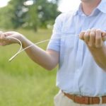
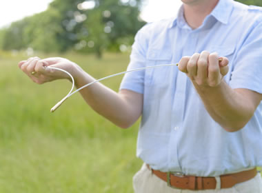
Figure 1: A person using a forked-stick dowsing rod in a field. The dowser walks through the field with the dowsing rod. When he walks over a location that has the potential of yielding water, the dowsing rod will rotate in his hands and point toward the ground. Many dowsers prefer forked sticks made from willow, peach, or witch hazel wood.

What Is Dowsing?

“Dowsing,” “water witching,” “divining,” and “doodlebugging” are all names for the practice of locating groundwater by walking the surface of a property while holding a forked stick, a pair of L-shaped rods, a pendulum, or another tool that responds when the person moves above a location that will yield an adequate flow of water to a drilled well (see Figure 1).

People who practice dowsing believe that groundwater moves in subsurface seams, veins, or streams that must be intersected by the drill to produce an adequate flow of water. They believe that locations where this water is present are surrounded by forces that will produce a response in their tools. Forked sticks held in front of a dowser will be deflected toward the ground, a pair of L-shaped rods held lightly in the dowser’s hands will cross one another, and a pendulum suspended on a string will deflect from vertical as the dowser moves over a good location.

Why Do Landowners Hire Dowsers?

Drilling a water well can cost thousands of dollars. It is a major investment that many landowners are hesitant to make without professional consultation. They want to be sure that the well is drilled in a location where it will produce water of adequate quantity and quality. This is why many people hire a dowser. They want to drill a successful well, close to their house, where the cost of installing water lines and an electrical conduit will be minimal and where a drilling rig can be easily driven. Read more

The History of Protection: How Petersburg Was Saved from Floods

The Northern capital, built in the delta of Neva, always had uneasy relations with the river and the sea. For all its history the city has experienced more than 300 floods! The threat of flooding has always been real, and all this time rulers and scientists have devised ways to prevent destruction and sacrifice. This we tell in the next Water-gallery.

To find the correct solution to the problem, it was necessary to understand its causes. Why did the water in the Neva rise and fall upon the city? Who is to blame – the sea or the river? On this account for a long time there was no single point of view, and a variety of protection methods were offered. Read more

Geologists Mapped Water Reserves on Moon

Specialists of the University of Brown (USA) compiled a detailed map of the water reserves in the lunar soil based on data obtained from the Moon Mineralogy Mapper spectrometer. The spectrometer was equipped with a space probe Chandrayaan-1, which went to the satellite of the Earth in 2008.

If you look at the map, you can see that most of the water is situated in the circumpolar regions of the Moon. But “more” does not mean much: the concentration of H2O at the poles is 500-750 ppm (millionths of a share). Nevertheless, traces of moisture are present throughout the surface. Read more