Once the fourth largest lake in the world, Central Asia’s shrinking Aral Sea has reached a new low, thanks to decades-old water diversions for irrigation and a more recent drought. Satellite imagery released this week by NASA shows that the eastern basin of the freshwater body is now completely dry.
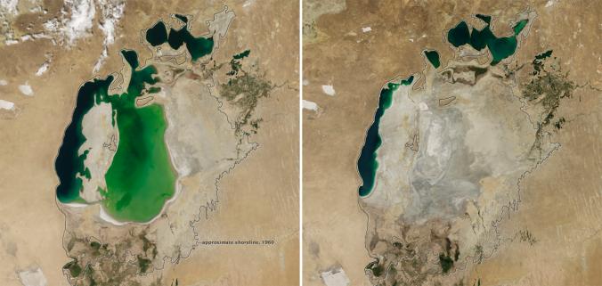
In 2000 (left), Asia’s Aral Sea had already shrunk to a fraction of its 1960 extent (black line). Further irrigation and dry conditions in 2014 (right) caused the sea’s eastern lobe to completely dry up for the first time in 600 years.
“It is likely the first time it has completely dried in 600 years, since medieval desiccation associated with diversion of Amu Darya [river] to the Caspian Sea,” Philip Micklin, an Aral Sea expert and a geographer emeritus from Western Michigan University, in Kalamazoo, told NASA about the sea’s eastern basin. (See “Photos: Dried Up Aral Sea Aftermath.”)
An image made by NASA’s Terra satellite in August and released on Tuesday shows the sea without its eastern lobe, a noticeable difference from an image made on August 25, 2000.
Actually a freshwater lake, the Aral Sea once had a surface area of 26,000 square miles (67,300 square kilometers). It had long been been ringed with prosperous towns and supported a lucrative muskrat pelt industry and thriving fishery, providing 40,000 jobs and supplying the Soviet Union with a sixth of its fish catch.
The Aral Sea was fed by two of Central Asia’s mightiest rivers, the Amu Darya and the Syr Darya. But in the 1960s, Soviet engineers decided to make the vast steppes bloom. They built an enormous irrigation network, including 20,000 miles of canals, 45 dams, and more than 80 reservoirs, all to irrigate sprawling fields of cotton and wheat in Kazakhstan and Uzbekistan. (See “8 Rivers Run Dry From Overuse.”)
But the system was leaky and inefficient, and the rivers drained to a trickle. In the decades that followed, the Aral Sea was reduced to a handful of small lakes, with a combined volume that was one-tenth the original lake’s size and that had much higher salinity, due to all the evaporation.
As a result of the drying over the past decades, millions of fish died, coastlines receded miles from towns, and those few people who remained were plagued by dust storms that contained the toxic residue of industrial agriculture and weapons testing in the area. (See “Before and After Photos: Vast Aral Sea Vanishing.”)
By 2000, the lake had separated into the North (Small) Aral Sea in Kazakhstan and the South (Large) Aral Sea in Uzbekistan. The South Aral had further split into western and eastern lobes. The eastern lobe of the South Aral nearly dried up in 2009 but rebounded in 2010 after more rain.
According to Micklin, the recent desiccation is due to continued withdrawals from the rivers for irrigation and less rain and snow in the Pamir Mountains, whose runoff feeds the Amu Darya.
In 2005, a World Bank‒funded dam and restoration project began in Kazakhstan with the goal of improving the health of the Syr Darya and increasing the flow into the North Aral Sea. Since then the water level has risen there and salinity has decreased.
But Micklin said he expects cyclical drying will “continue for some time” in the eastern basin.
Source: http://news.nationalgeographic.com/
Dear User/Visitor! Please, answer on our questions: tick off one of the positions – your answer will make us able to improve our site and make it more interesting and useful!
