Set against the velvet blackness of outer space, our home planet looks like a “blue marble”—bright, shimmering, and mostly fluid. Indeed, it is the abundance of water on its surface that gives Earth its blue appearance. Water covers approximately 70 percent of our world’s surface. So it would seem that finding water is a trivial task. Yet only 2.5 percent of the Earth’s water is fresh and thus suitable for consumption.

Not only that, but of that 2.5 percent, more than two-thirds is locked away in glaciers and not particularly able to help meet the growing demands of society. By far, the most abundant and available source of fresh water is underground water supplies or wellsprings known as aquifers. Therefore, scientists and natural resource managers are very interested in tracking how these underground reservoirs of fresh water are changing with time.
Launched in 2002, a pair of identical satellites that make up NASA’s Gravity Recovery And Climate Experiment (GRACE) are tackling the problem in an unexpected way: they are weighing Earth’s fresh water from space. Serving as a sort of “divining rod” in space that moves in response to a powerful, fundamental force of nature—gravity—the satellites respond to changes in Earth’s gravitation field that signal shifts in the movement of water across and under Earth’s surface.
Only 2.5 percent of the Earth’s water is fresh (top). Nearly one-third of this small percentage of available freshwater is stored in underground aquifers (bottom), which account for the vast majority of readily accessible fresh water. GRACE’s expected ability to monitor changes in these unseen water reserves from space will be a significant addition to hydrological studies. (Graph by Alex McClung based on data from the United Nations Environmental Programme.)
John Wahr, research scientist at the University of Colorado, pioneered this new technique in 1998, working with the GRACE team, by creating a computer simulation of what he thought the Earth’s gravity field would look like to the GRACE mission. He divided the total gravity field into its separate components, estimating how much of the signal came from the oceans, landmasses, atmosphere, and subsurface water. Next, he subtracted off the other components of the gravity field and deduced how much of the total gravity signal was caused by underground water.
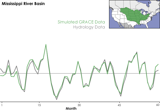
Using simulated GRACE data, John Wahr demonstrated that month-to-month water storage changes could be retrieved from space. The graph above shows how well simulated GRACE retrievals (green line) compare to actual hydrological model data (gray line) in the Mississippi River Basin (area shown in green in map inset). (Graph by Alex McClung based on data from John Wahr.)
“The idea was to see if I could recover [underground] water storage from simulated GRACE data, in the presence of all the other signals [in Earth’s gravity field],” Wahr explains. Encouraged by the experiment, Wahr and his colleagues believe that GRACE will be able to detect subsurface water and they look forward to testing the theory now that GRACE data are being collected. Can these data be used to monitor changes in underground water over time? How precise will GRACE’s measurements be? Over how small an area can this technique be used effectively?
Earth’s Weighty Wellsprings
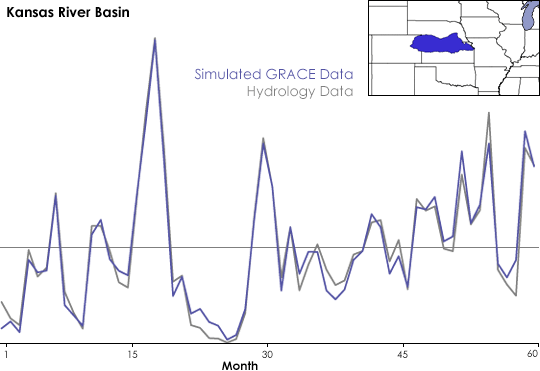
The graph above shows how well simulated water storage retrievals from GRACE (blue line) match up with actual hydrological model data (gray line) for an aquifer in northern Kansas, southern Nebraska, and eastern Colorado (area shown in blue on map inset). GRACE is much more sensitive to water storage changes over a large area like the Mississippi River Basin than it is over a smaller area; the two lines on the Mississippi River Basin graph follow each other more closely than do the lines on the graph above. (Graph by Alex McClung based on data from John Wahr.)
Water storage refers to groundwater, soil moisture, snow, ice, and surface waters. Groundwater is the portion of the water residing in underground aquifers. Scientists know that changes in climate and weather influence water storage, and vice versa, but they don’t fully understand how the relationship works. As a result, predicting water storage changes is difficult, even with sophisticated computer models. Scientists need more observations, but these are not easy to make over large areas. Ground-based measurements require lots of work and only describe water storage for a single location. Because of these difficulties, we don’t regularly and methodically survey the world’s aquifer systems, which means it’s tedious at best (and impossible in many cases) to assess regional changes in groundwater levels.
Two NASA missions offer a new perspective on this problem, and allow regional- and global-scale observations of the Earth, contributing a wealth of new information on water movement on and beneath the surface. The Advanced Microwave Scanning Radiometer for EOS (AMSR-E), onboard the Aqua spacecraft, has the ability to determine how much moisture is in surface soil. This observation gives scientists a more complete picture of the hydrologic cycle than they’ve ever had before, but it is far from a complete picture. AMSR-E is unable to penetrate beyond the top few centimeters of soil, so scientists still lack critical information on what’s going on in deeper soil moisture or aquifers.
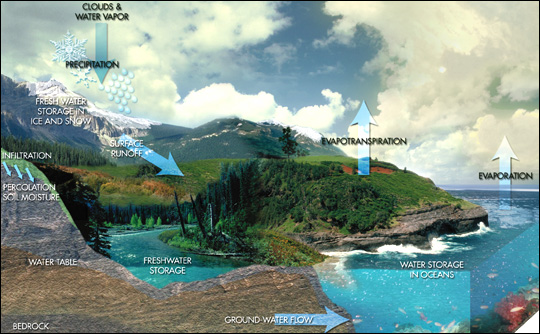
The image above shows the many processes of the Earth’s hydrologic cycle that contribute to total changes in water storage. Because a large portion of the Earth’s usable fresh water is located in underground aquifers, scientists are interested in determining how groundwater supplies are changing with time. GRACE offers an effective new means of studying the entire water column from space, and will be especially useful for looking at groundwater storage changes. (Image Courtesy NASA GSFC)
“GRACE is really the only instrumentation in space that can tell you much about deep water storage,” says Michael Watkins, Project Scientist for GRACE at NASA’s Jet Propulsion Laboratory (JPL). “These data are a key missing element that we can combine with these soil-moisture measuring missions [such as AMSR-E] to get a much better handle on the hydrologic cycle.”
Unlike most satellite remote sensors, GRACE doesn’t measure the electromagnetic energy reflected back to it from the Earth’s surface. Instead, as GRACE’s two satellites fly in tandem around the Earth, the distance between the two spacecraft to changes in response to variations in the Earth’s mass—and therefore gravity—on the surface below them. A device on the spacecraft can detect changes in the distance between the satellites as small as one millionth of a meter (smaller than a human red blood cell) and records this information along with the satellites’ exact position over the planet. The GRACE Science Team collects the data and translates these changes in distance into monthly maps of the Earth’s average gravity field.
GRACE takes advantage of the fundamental physical relationship between the mass of an object and the gravitational force exerted by that object—the greater the object’s mass, the stronger its gravitational field. If the mass (like underground water) in an object (such as the Earth) is free to move around, then the gravitational field of that object will change as the location of its center of mass changes. It turns out that over a time period of one month, water movement under the continents is one of the major causes of changes in the Earth’s mass distribution, and therefore its gravity field. The GRACE team aims to take advantage of this relationship between mass and gravity to track changes in Earth’s water storage.
Pioneering a New Technology
The graphics above help to illustrate how the positions of the two GRACE satellites change in response to variations in Earth’s gravity field. In the first drawing, the two spacecraft pass over the ocean and neither is affected. In the second drawing, the lead spacecraft encounters a change in gravity over the more dense land mass and pulls away from the trailing spacecraft, which is still over water. In the third drawing, the lead spacecraft moves back over water but now the trailing spacecraft changes position in response to the greater pull of gravity over the land mass.
Please note that these drawings are not to scale. In reality, the GRACE satellites are spaced about 220 km apart and changes in distance between them would be undetectable by human eyes. GRACE has an onboard microwave ranging system that makes extremely precise, continuous measurements of the distance between the two spacecraft as they orbit the Earth. (Graphics courtesy Chris Meaney, NASA GSFC)
Two hydrologists, Matt Rodell at NASA Goddard Space Flight Center, and Jay Famiglietti at the University of California, Irvine are studying the GRACE technique, and building on some of Wahr’s earlier work. “In 1997, Jay (my supervisor at the University of Texas at the time) told me about a new NASA satellite mission being planned that would measure the gravity with high enough precision to detect mass variations caused by water storage changes,” Rodell recalls. “I was skeptical at first, but after learning more, I decided to focus my doctoral research on that topic.” His Ph.D. now completed, Rodell is working in the Hydrological Sciences Branch at NASA’s Goddard Space Flight Center, continuing his research on this application for GRACE data.
Rodell and Famiglietti conducted two initial studies of the GRACE technique. In their first experiment, the idea was to test the limits of the proposed GRACE technique and see over how small an area the satellite could be expected to detect changes in water storage. To do this the scientists needed to know, first, how sensitive to changes in Earth’s gravity did GRACE’s designers think the satellites would be, and second, what kinds of water storage changes was GRACE likely to encounter in the real world. Because not much real-world data exists on changes in water storage, the scientists turned to computer model simulations of seasonal and climatic changes in water storage from twenty different river basins of varying size all around the world.
Rodell and Famiglietti compared these modeled river environments to the GRACE team’s projections of the satellites’ capabilities and found that data from GRACE should be able to determine monthly water storage changes for areas of approximately 200,000 square kilometers or larger. “Water storage changes in the whole Mississippi River Basin, for example, should be no problem for GRACE,” explained Rodell. “It’s a large area, and there are large changes in water storage. The Salt Lake Basin, on the other hand, is too small and dry for GRACE to be able to detect changes in that region.”
The scientists relied on modeled water storage changes because for many parts of the world, ground-based observations don’t exist. But in their second study, the scientists wanted to go beyond models and to verify the GRACE technique against actual observed data, so they focused on the state of Illinois where extensive long-term records of water storage data exist. Illinois has an area of 145,800 square kilometers (below the minimum threshold for GRACE to detect monthly water storage changes) so the scientists had to scale up the results obtained in Illinois to larger regions by assuming conditions in the surrounding area are similar to those in Illinois. Again, the results were encouraging and indicated that GRACE would successfully detect water storage changes in areas larger than 200,000 square kilometers.
Generally speaking, the GRACE technique will be more accurate for larger areas over longer time intervals. For example, GRACE will be able to detect seasonal (three-month) and annual changes in water storage in an area the size of Illinois, but not month-to-month changes. In contrast, in an area the size of the Mississippi River basin (3,165,500 square kilometers), GRACE will likely be able to detect water storage changes at monthly, seasonal, and annual time intervals. In many locations, changes between seasons have the highest magnitude, and thus seasonal water storage change may be easiest to detect using the GRACE technique.
Challenges and Limitations to Using the GRACE Technique
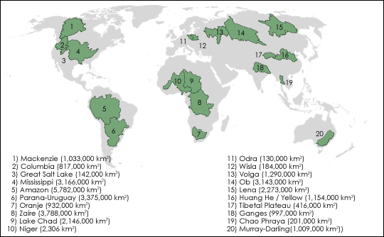
To find out over how small an area GRACE could accurately monitor water storage changes, Matt Rodell and Jay Famiglietti modeled twenty river basins around the world (areas shown in green above) and compared the modeled hydrological data to scientists’ predictions of GRACE’s capabilities. They confirmed that the GRACE technique is increasingly effective as the size of the area studied increases. (Map by Alex McClung based on data by Matt Rodell.)
GRACE measures changes in Earth’s gravity field by measuring the distance between the two satellites every five seconds. In a way, you could say the GRACE satellites only have eyes for each other; they aren’t really looking at the Earth. Using raw GRACE measurements, all the scientists can tell is that at a specific point above the Earth, the two satellites were closer together or farther apart than they were five seconds ago. They can’t tell much else; the raw data is just a distance measurement and a position over the planet. Hundreds of kilometers below them, something above, below, or beneath Earth’s surface caused gravity to pull a little harder or a little weaker on the satellites as they moved overhead, and the scientists have the challenge of figuring out what caused the change.
So what is that something? According to Watkins, “It could be almost anything,” and that makes the job of sorting out the signal quite difficult. There are rapid and slow changes caused by everything from the shifting of water in the oceans, to the movement of water vapor and other components in the atmosphere, to the shifting of solid rock in the lithosphere. Other changes can occur due to tidal effects caused by the Sun and the Moon. The different topographic features along the satellite’s path—mountain ranges, deep ocean trenches, rock formations rich in heavy, dense metal—also influence the gravity field. The gravity field can even change in response to topographic features that have not been present for millennia. For example, the Earth’s crust is still “rebounding” from the massive weight that was removed when the glaciers retreated at the end of the last ice age. Before the hydrologists can use the data, the GRACE Science Team has to sort out all of these different effects.
There are some gravity effects that change extremely rapidly, some almost minute by minute. This might include ocean tides or weather systems moving across the planet. Sometimes the variability in the gravity field over one month can be as large as the average value for the month, but GRACE can’t detect this variability. When GRACE collects data, it doesn’t scan the whole Earth at once. It takes about a month for the whole Earth to be sampled. This means that GRACE cannot view the Earth quickly enough to measure the fastest changes in the gravity field from space. Therefore, in order to prepare the gravity solution for use in hydrological applications, the changes that occur over a timescale shorter than one month, mostly related to the atmosphere and ocean, have to be accounted for using models. Otherwise, the estimate of the monthly average gravity field would not be as reliable for use by the hydrologists.
The monthly average gravity field maps provided to hydrologists like Wahr and Rodell have been corrected for these rapid variations. However, there are still lingering effects of atmospheric and oceanic phenomena that change over monthly intervals or longer that must be taken into account before they can isolate water storage change. Using model simulations of the atmosphere, ocean, and solid Earth, the hydrologists can clean up any leftover, non-water-related-effects, and what they end up with is a “corrected” gravity field that represents only the effects of water movement.
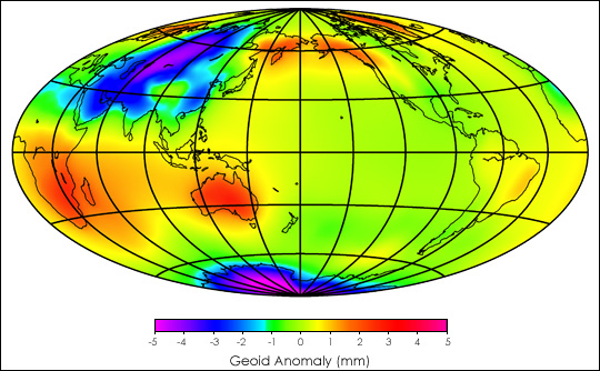
The changes in Earth’s gravity signal caused by water storage can be overshadowed by changes caused by movements in the atmosphere and oceans. The image above is the result of a computer model that predicted where and by how many millimeters these atmosphere and ocean movements would have increased or decreased the average gravity signal in August 2002 compared to the yearly average for 2001. Yellows, oranges, and reds are places where the average August gravity signal was higher than the 2001 average, while greens, blues, and purples show where it was lower.
But, there is still the issue of how to account for the influence of the Earth’s topography. The influence of the geographical variation in the Earth’s mass on the gravity field is much larger than that of water storage, and errors in the solution for the mean field could obscure the smaller water storage signals. Hydrologists get around this problem by comparing GRACE observations from two different time periods and assuming that any change observed is caused by water storage. After all, we can pretty much count on the fact that if a mountain was in a particular place last month, it will be in the same place this month, and thus its effect on the gravity field will be the same from month to month. By looking at the average monthly gravity field from two different time periods and taking a difference between the two, the part of the signal that is more or less constant over short time intervals cancels out and what remains is the change in the gravity field caused by water storage change. Wahr and Rodell can then relate this value to an equivalent water level change in a specific region by using a simple conversion that describes how much water it would take to produce the mass change that GRACE observed over the region.
Thus, this GRACE technique is not a way to measure exact water storage amounts from space, it can only tell us how water storage changes with time. Therefore, this technique cannot be used to measure how much water is stored in the Mississippi River Basin at a particular instant in time, but it can certainly be used to see how the water storage changes in that area over a month, a season, or a year. Such information can be extremely useful for water resource managers.
Honing in on Groundwater
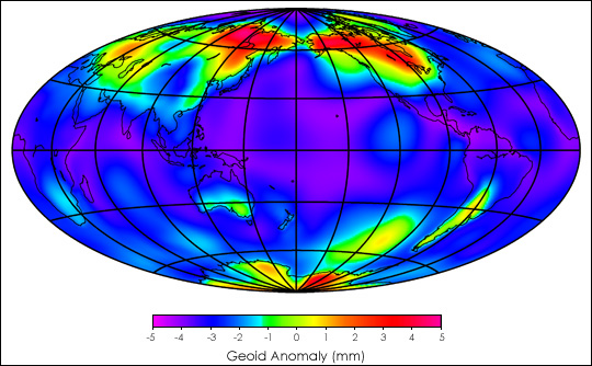
The Earth’s gravity signal changes day-to-day, even minute by minute. The image above shows how the average variability in Earth’s gravity field in August 2002 compared to the average variability during 2001. The red and pink areas show where the variation measured in August 2002 is the most different from the variation measured for the year 2001, while the blue and purple areas show where the variation measured in August 2002 is just about the same as the variation measured for the year 2001. The variability has to be accounted for using models in order to produce a mean gravity field that is useful for hydrologic applications.
The first steps in the analysis of GRACE data provide an estimate of total water storage change that includes all groundwater, soil moisture, snow, ice, and surface waters. When combined with additional information, the GRACE technique may be taken a step further and used to focus solely on groundwater changes. This raises the very exciting possibility of tracking changes in aquifer water storage from space. Rodell and Famiglietti demonstrated this potential by examining data from the High Plains Aquifer located in the midwestern United States.
“GRACE will provide estimates of changes in total terrestrial water storage over large areas [greater than 200,000 square kilometers] on a monthly basis,” Rodell states. “We hydrologists need to find a way to [separate] those total changes into changes in soil moisture, snow, groundwater, etc.”
The hydrologists want to take GRACE’s measure of continental water storage and break it down into its component parts so they can determine how much groundwater is stored in aquifers. In their study, Rodell and Famiglietti found that for the High Plains region, the variability of snow and surface water made insignificant contributions to total water storage variability when compared to the contributions made by groundwater and soil moisture. This means that soil moisture is the sole component that has to be removed from the gravity data to get at elusive groundwater changes. It turns out that the U.S. High Plains Aquifer has been well sampled and studied, and so scientists have long-term, detailed records on soil moisture change in the region. So, by subtracting the soil moisture contribution, the remaining change in GRACE’s measure of total water storage is likely due to changes in groundwater.
Rodell and Famiglietti’s study shows that the GRACE technique will allow for estimates of annual groundwater change over the High Plains that are within about 8.7 millimeters of their actual value. This level of accuracy may only represent a modest improvement for a well-sampled aquifer like the High Plains Aquifer, but there are many places in the world, such as northern Africa, India, and the Arabian peninsula, where an estimate of the water levels within a centimeter or less of the actual value would be extremely valuable. GRACE may help to reveal groundwater depletion in areas of the world where such measurements are not systematically recorded or where they are not disclosed for political reasons. Even over more extensively sampled areas, the prospect of a technique that is less labor intensive and does not require an extensive network of wells makes GRACE an attractive option.
Overall, the GRACE technique offers an objective, unbiased method for monitoring water storage changes on a global scale. According to GRACE Principal Investigator Byron Tapley, of the University of Texas, “GRACE is our first real chance to demonstrate the measurement of gravity as a new remote-sensing tool that will play a major role in our understanding of the Earth and its climate.”
Source: https://earthobservatory.nasa.gov/
Dear User/Visitor! Please, answer on our questions: tick off one of the positions – your answer will make us able to improve our site and make it more interesting and useful!
