I’ve touched on lake-effect snows, the classic pattern in the Upper Midwest and western New York State in which frigid winds blowing over relatively warm Great Lakes waters generate persistent cloud bands and lots of snow.
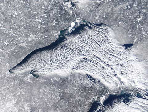
Cold air streaming over relatively warm Great Lakes waters produced streaming bands of clouds and so-called “lake effect” snow this week. Credit NASA / University of Wisconsin
The image above, to which I was directed by a Dot Earth reader, Mike Mangan, was posted earlier today by the Michigan television meteorologist Bill Steffen.
For the view from the ground click here.
There’s more on this imagery, generated with data collected by NASA satellites on Wednesday, from the University of Wisconsin, Madison, Space Science and Engineering Center. Visit the center’s Web site to see animated views of the cloud bands.
If you, like me, can’t get enough of the dynamics of our amazing atmosphere, please bookmark ImaGeo, the visual Discover Magazine blog of my longtime friend, the science writer, photographer and journalism professor Tom Yulsman.
By Andrew C. Revkin
Source: http://dotearth.blogs.nytimes.com/
Dear User/Visitor! Please, answer on our questions: tick off one of the positions – your answer will make us able to improve our site and make it more interesting and useful!
